This item has been sold, but you can get on the Waitlist to be notified if another example becomes available, or purchase a digital scan.
1534 Joachim Vadian Map of the World after Münster and Waldseemüller
World-vadian-1534$7,500.00


Title
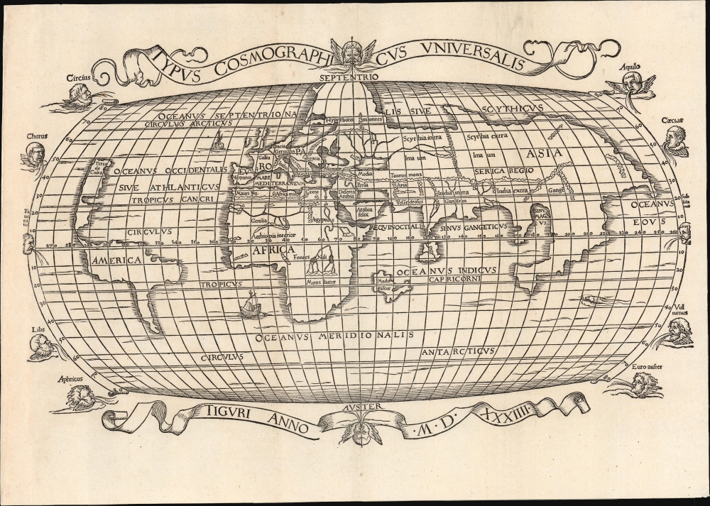
Typus Cosmographicus Universalis.
1534 (dated) 9.25 x 15.25 in (23.495 x 38.735 cm) 1 : 110000000
1534 (dated) 9.25 x 15.25 in (23.495 x 38.735 cm) 1 : 110000000
Description
This is Joachim Vadian's rare 1534 woodcut map of the world, combining a largely Ptolemaic formulation of Europe and Asia with what was a modern depiction of Africa and the New World. It is one of the earliest maps to name America. While largely derived from the map Sebastian Münster prepared for Simon Grynaeus in 1532, it is in many ways a better representation of Münster's source, the 1507 map of Martin Waldseemüller.
A Closer Look
The map presents, on an oval projection, a highly evocative and transitional discovery-era world. Europe, Asia, and Africa start from a Ptolemaic model (note the delineations of the Black Sea, the course of the River Nile, and the mapping of South Asia). In broadest terms, Shirley's criticism is fair: the map's outline and title are drawn from Münster's world map, published in 1532 Grynaeus' Novus Orbis Regionum. This, in turn, had been derived from Martin Waldseemüller's 1507 world map. Likely Vadian had access to both Münster's map and the 1507 original: Madagascar appears here in the odd 'V' shape of the Waldseemüller, whereas Münster covered that part of the ocean with a large text box. Moreover, the pattern of mountains shown in central and south Asia resembles the 1507 map more closely than the 1532. Vadian might have sourced these features alone from the 1520 Apianus world map - another Waldseemüller derivative. But the array of rivers shown flowing into the Caspian Sea - which appear neither on the Apianus nor the Münster - suggest a direct connection to the Waldseemüller, on which they do appear.A Discovery-Era World
To a foundation of Ptolemaic geography, the present work adds evidence of new discoveries. Africa is circumnavigable, and the Indian Ocean is accessible by sea (unlike Ptolemy's landlocked sea). Beyond the Malay Peninsula and the 'Sinus Magnus' is the so-called 'Dragon's Tail,' left over from Ptolemy's land bridge connecting China to Africa and encompassing the Indian Ocean. To the West, North and South America are shown as distinctly separate from Asia. Though not the first to do so, this is still among the earliest maps to use the placename 'America.' Vadian follows Münster's puzzling choice in identifying North America as Terra de Cuba - Waldseemüller did not do so on his 1507 map, but did on his 1516 Carta Marina. (Indeed, Waldseemüller, on his 1516 map, suggested that 'Terra de Cuba' was part of Asia.) Münster's choice to retain 'Terra de Cuba' while dispensing with 'Asie Partis' was an important assertion of both the separation of Asia and America and the existence of a distinct, new ocean.Discerning the Pacific
To that point, Vadian's map adds a placename for this ocean that appears to be unique. Waldseemüller in 1507 termed it the Eastern Indian Ocean (Oceanus Orientalis Indicus). His 1516 Carta Marina instead refers to this body of water as the Sinus Magnus, contradicting the idea of a new ocean and supporting the idea that America was part of Asia (essentially, the Dragon's Tail). The 1532 Münster does not name the ocean at all. Vadian names this 'Oceanus Eous,' (Ocean of the East, or Ocean of the Dawn). It is the first European name for this ocean (of which we are aware), which disassociates that body from both the Indian Ocean and the Ptolemaic Sinus Magnus. This represents an important early step in identifying the Pacific as a completely new ocean. Vadian does not include Japan, despite both of his main sources having done so.Mapping the North
To the north of Europe, present but shorn of detail, is a landmass suggesting Scandinavia but spanning far north of the Arctic Circle. This differs from a similar formulation on the 1532 Münster, which does not reach as far north as here but includes a river extending from the Black Sea that does not appear on this map. On the other hand, the present work also displays a network of rivers flowing into the Caspian Sea from the north. These were not new to Vadian or Waldseemüller: they appear on Ptolemaic maps of the region north of the Caspian. The purpose behind Vadian's choice is, unfortunately, opaque to us.The Garden of Eden
This map only appeared in the first edition of Vadian's Epitome, and it was the only map included in that edition of the work as a visual aid to his description of the world. This was informed by classical and Biblical sources. Vadian was an active and influential Protestant when the Reformation came to Switzerland, and much of his discussion of the world was couched in religious terms. Indeed, a bit more than 15 pages of the work are committed to the question of the location of the Garden of Eden. Vadian concludes that the terrestrial Eden had encompassed the whole world, and that the Fall of Man had marred it in entirety. To a certain extent, then, the map would represent for Vadian not just the world as it was being revealed to Man but also the entirety of the Paradise that Man had lost.Publication History and Census
This map was executed for inclusion in Vadian's 1534 Epitome trium terrae partium Asiae, Africae et Europae. It was included in only that edition, in which this was the sole map. Later editions would instead include a world map and an array of regional maps sourced from Honter. This is the 1534 first state of the map, of three: a second state (easily distinguished and dated) appeared in the 1542 edition of Glareanus; a third state appeared in 1572. We see only four separate examples of the present, 1534 state listed in OCLC, held by the Osher Library, the Zurich Zentralbibliothek, the University of Michigan, and the Biblioteca Nacional de Espana.CartographerS
Vadian, born Joachim von Watte (November 29 1484 - April 6, 1551), was a Swiss doctor, humanist, and geographer. He was born to a prominent merchant family in St. Gallen, Switzerland, but studied broadly at the University of Vienna, becoming a prolific humanist author and debater. There he became a professor, and went on to study medicine, the natural sciences, and geography. He rose to the position of Dean in 1516 and earned his doctorate. (He was not solely a creature of the mind; in 1518, he executed the first documented ascent of Lucerne's Pilatus mountain.) Thereafter, he returned to St. Gallen to become city physician. With the advent of the Reformation, he became an active Protestant (having married the daughter of a prominent Anabaptist). He became friends with reformist Ulrich Zwingli, who introduced Vadian to the textual underpinnings of his new faith.
When his father, by then a member of the city council, died in 1520, von Watte succeeded his father in that role. Thus, he was in a position to advocate for the Protestant cause from a position of power. His election as city mayor in 1526 lent him the authority to lead the conversion of St. Gallen to Protestantism; he managed to retain his position even after the Catholic victories in the Second War of Kappel.
Vadian was a prolific writer; his student output was largely poetry. Later he would produce several theological texts, but he also produced histories and geographical works, most notably his Epitome trium terrae partium Asiae, Africae et Europae. He was also a voracious book collector: upon his death his copious library was donated to his city, providing the core of the Cantonal Library of St. Gallen, named after its illustrious first donor.
More by this mapmaker...
Sebastian Münster (January 20, 1488 - May 26, 1552), was a German cartographer, cosmographer, Hebrew scholar and humanist. He was born at Ingelheim near Mainz, the son of Andreas Munster. He completed his studies at the Eberhard-Karls-Universität Tübingen in 1518, after which he was appointed to the University of Basel in 1527. As Professor of Hebrew, he edited the Hebrew Bible, accompanied by a Latin translation. In 1540 he published a Latin edition of Ptolemy's Geographia, which presented the ancient cartographer's 2nd century geographical data supplemented systematically with maps of the modern world. This was followed by what can be considered his principal work, the Cosmographia. First issued in 1544, this was the earliest German description of the modern world. It would become the go-to book for any literate layperson who wished to know about anywhere that was further than a day's journey from home. In preparation for his work on Cosmographia, Münster reached out to humanists around Europe and especially within the Holy Roman Empire, enlisting colleagues to provide him with up-to-date maps and views of their countries and cities, with the result that the book contains a disproportionate number of maps providing the first modern depictions of the areas they depict. Münster, as a religious man, was not producing a travel guide. Just as his work in ancient languages was intended to provide his students with as direct a connection as possible to scriptural revelation, his object in producing Cosmographia was to provide the reader with a description of all of creation: a further means of gaining revelation. The book, unsurprisingly, proved popular and was reissued in numerous editions and languages including Latin, French, Italian, and Czech. The last German edition was published in 1628, long after Münster's death of the plague in 1552. Cosmographia was one of the most successful and popular books of the 16th century, passing through 24 editions between 1544 and 1628. This success was due in part to its fascinating woodcuts (some by Hans Holbein the Younger, Urs Graf, Hans Rudolph Manuel Deutsch, and David Kandel). Münster's work was highly influential in reviving classical geography in 16th century Europe, and providing the intellectual foundations for the production of later compilations of cartographic work, such as Ortelius' Theatrum Orbis Terrarum Münster's output includes a small format 1536 map of Europe; the 1532 Grynaeus map of the world is also attributed to him. His non-geographical output includes Dictionarium trilingue in Latin, Greek, and Hebrew, and his 1537 Hebrew Gospel of Matthew. Most of Munster's work was published by his stepson, Heinrich Petri (Henricus Petrus), and his son Sebastian Henric Petri. Learn More...
Martin Waldseemüller (September 11, 1470 - March 16, 1520) was a German cartographer, astronomer, and mathematician credited with creating, along with Matthias Ringmann, the first map to use the placename America. He was born in Wolfenweiler, near Freiburg im Breisgau. Waldseemüller studied at the University of Freiburg and, on April 25, 1507, became a member of the Gymnasium Vosagese at Saint-Dié. Martin Waldseemüller was a major proponent of theoretical or additive cartography. Unlike contemporary Portuguese and Spanish cartographers, who left maps blank where knowledge was lacking, Waldseemüller and his peers speculated based upon geographical theories to fill unknown parts of the map. He is best known for his Universalis Cosmographia a massive 12-part wall map of the world considered the first map to contain the name America, today dubbed as 'America's Birth Certificate'. This map also had significance on other levels, as it combined two previously unassociated geographical styles: Ptolemaic Cartography, based on an ancient Greek model, and the emergent 'carta marina', a type of map commonly used by European mariners in the late 15th and 16th centuries. It also extended the traditional Ptolemaic model westward to include the newly discovered continent of America, which Waldseemüller named after the person he considered most influential in its discovery, Amerigo Vespucci. When Waldseemüller died in 1520, he was a canon of the collegiate Church of Saint-Dié. In contemporary references his name is often Latinized as Martinus Ilacomylus, Ilacomilus, or Hylacomylus. Learn More...
Source
Vadian, J., Epitome Trium Terrae Partium Asiae, Africae et Europae, (Zurich: Froschauer) 1534.
Condition
Very good. Trimmed at left as is often the case with this map; expertly and nearly invisibly extended and reinstated. Else a bold, attractive example.
References
OCLC 1284588340. Shirley, R., The Mapping of the World #70.