This copy is copyright protected.
Copyright © 2025 Geographicus Rare Antique Maps
Digital Image: 1700 / 1726 Wells Double Hemisphere Map of the World
World-wells-1700_d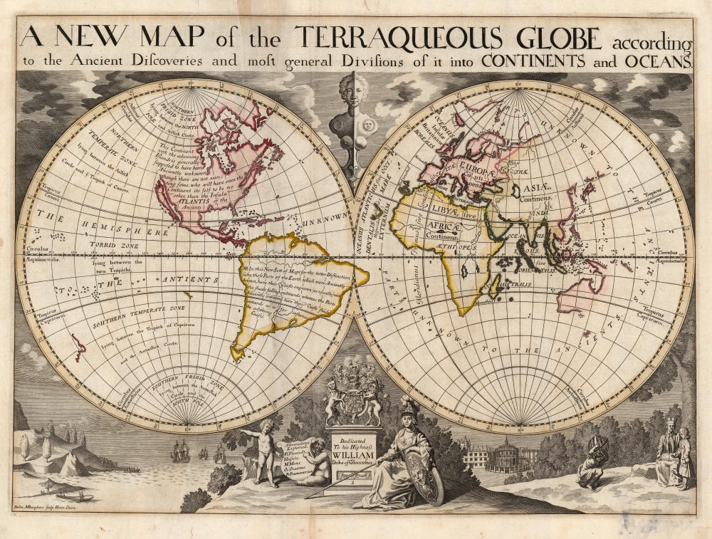

FOR THE ORIGINAL ANTIQUE MAP, WITH HISTORICAL ANALYSIS, CLICK HERE.
Digital Map Information
Geographicus maintains an archive of high-resolution rare map scans. We scan our maps at 300 DPI or higher, with newer images being 600 DPI, (either TIFF or JPEG, depending on when the scan was done) which is most cases in suitable for enlargement and printing.
Delivery
Once you purchase our digital scan service, you will receive a download link via email - usually within seconds. Digital orders are delivered as ZIP files, an industry standard file compression protocol that any computer should be able to unpack. Some of our files are very large, and can take some time to download. Most files are saved into your computer's 'Downloads' folder. All delivery is electronic. No physical product is shipped.
Credit and Scope of Use
You can use your digial image any way you want! Our digital images are unrestricted by copyright and can be used, modified, and published freely. The textual description that accompanies the original antique map is not included in the sale of digital images and remains protected by copyright. That said, we put significant care and effort into scanning and editing these maps, and we’d appreciate a credit when possible. Should you wish to credit us, please use the following credit line:
Courtesy of Geographicus Rare Antique Maps (http://www.geographicus.com).
How Large Can I Print?
In general, at 300 DPI, you should at least be able to double the size of the actual image, more so with our 600 DPI images. So, if the original was 10 x 12 inches, you can print at 20 x 24 inches, without quality loss. If your display requirements can accommodate some loss in image quality, you can make it even larger. That being said, no quality of scan will allow you to blow up at 10 x 12 inch map to wall size without significant quality loss. For more information, it is best consult a printer or reprographics specialist.
Refunds
If the high resolution image you ordered is unavailable, we will fully refund your purchase. Otherwise, digital images scans are a service, not a tangible product, and cannot be returned or refunded once the download link is used.
Edward Wells (1667 - 1727) was an English mathematician, geographer, and classical scholar based at Christ Church College, Oxford. Wells trained for the ministry but quickly found himself unsuited to religious life and instead applied for an academic position at Oxford, where he authored numerous well respected works on a wide range of mathematical and scientific topics. He tutored Prince William, the sickly son of Queen Anne, who was likely about 11 at the time this map was prepared. Wells dedicated nearly all of the maps in his atlas, A New Sett of Maps both of Ancient and Present Geography, to the young prince - quite possibly posthumously, as William died in July of 1700 shortly prior to the publication of the atlas. Nonetheless, Wells' geography proved popular and was published in number editions well into the 1730s. More by this mapmaker...
Michael Burghers (1647? - 1727) was an Amsterdam-born English engraver active in Oxford, regarded by contemporaries as 'the best general engraver in England.' He produced plates for Robert Plot, Edmund Gibson, and in particular a number of maps for Edmund Wells' A new sett of maps... among other works. He was baptized a Lutheran in Amsterdam in 1648, but by 1673 had established himself in Oxford. He was naturalized in 1685 and became official engraver for Oxford University in 1694. Learn More...
Copyright © 2025 Geographicus Rare Antique Maps | Geographicus Rare Antique Maps
This copy is copyright protected.
Copyright © 2025 Geographicus Rare Antique Maps