1907 Scarborough Wall Map of the World w/ Flags and Leaders' Portraits
WorldFlagsRulers-scarborough-1907$550.00


Title
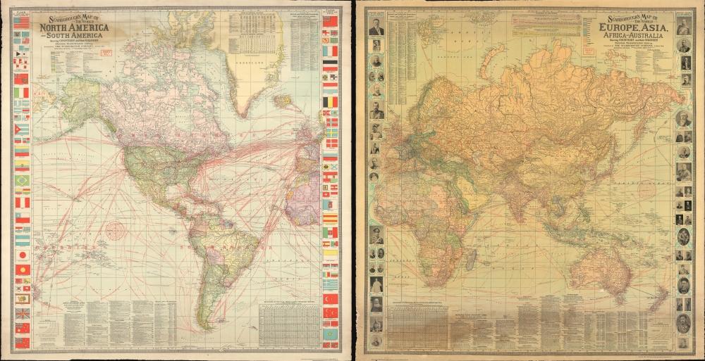
Scarborough's Map of the World North America and South America Shewing Countries and their Colonies Principal Transportation Lines etc. / Scarborough's Map of the World Eruope, Asia, Africa and Australia Shewing Countries and their Colonies Principal Transportation Lines etc.
1907 (dated) 41 x 40 in (104.14 x 101.6 cm) 1 : 25000000
1907 (dated) 41 x 40 in (104.14 x 101.6 cm) 1 : 25000000
Description
An impressive large-format double-sided 1907 wall map of the world by the London branch of the Scarborough Company. It provides a wealth of information on infrastructure, transportation, economic development, and the relative military might of different countries.
A Closer Look
The map is on a single sheet which has been printed on both sides: one detailing the Western Hemisphere, including the Americas, and the other detailing the Eastern Hemisphere, including Europe, Africa, Asia, and Australia. Particular attention has been paid to the global railroad, telegraph, and steamship networks. At the same time, caravan routes across Central Asia and ancient ruins are also marked. Information ranging from the locations of British and American Consulates, city indexes, and population statistics to ocean currents and the regular extent of ice pack in the Arctic is recorded, including in many tables and graphs surrounding the map. In the margins, flags of various countries are presented on the Western Hemisphere sheet, as are portraits of the rulers of countries on the Eastern Hemisphere sheet.Publication History and Census
This map was first issued in 1906 by the Scarborough Company of Indianapolis, Indiana. It was reissued in 1907 - the present example - for the London branch of the firm, based at 5 Arundel Street, Strand. Already a scarce map, this example is especially so due to the inclusion of the flags and portraits of rulers. We note only two examples of this presentation in institutional collections - at the University of Illinois at Urbana-Champaign and the Pennsylvania State University - and it has only appeared on the market once in recent years.Cartographer
Scarborough Company (1885 - 1913) was founded by the brothers Walter C. Scarborough (June 4, 1862 - May 9, 1904) and Howard G. Scarborough (December 23, 1867 - June 10, 1905). Walter, the older brother, was born in Providence, Rhode Island, and studied at the Boston University Law School. The Scarborough brothers founded their map publishing concern in 1885. Initially, there were three separate firms: the National Publishing Company (Portland, Maine, 1897), later based in Boston; the Dominion Publishing Company, based in Canada; and the Scarborough Publishing Company, based in London. These three firms each published semi-independently but were merged with a capital of 1,000,000 USD in 1902, subsequently publishing under the Scarborough imprint. Howard took over full management of the Scarborough in 1904 when Walter died. Howard was also in poor health, suffering from tuberculous, and relocated to Europe in 1900, where he lived in a sanatorium. He returned to the United States in 1902, settling first in Asheville, North Carolina, then at a sanatorium community in Oracle, Arizona. Until his death, he managed the Scarborough Company remotely. From about 1904, there was another branch of the firm located at 227 East Ohio Street in Indianapolis, Indiana. After Howard's 1905 death, the management of the firm, as well as its principal manufacturing and distribution points, was relocated to Indianapolis. In 1913, it became the Scarborough Motor Guide Company (c. 1913 - c. 1933). More by this mapmaker...
Condition
Good. Spot of discololration and light reinstated loss, upper left, to the right of compass rose.
References
OCLC 247463415.