This item has been sold, but you can get on the Waitlist to be notified if another example becomes available, or purchase a digital scan.
1841 Parisis Schoolgirl Map of the World on unusual Polar Projection
WorldPolarProjection-parisis-1841$1,250.00

Title
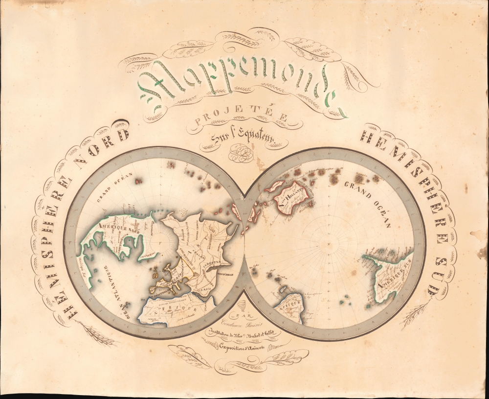
Mappemonde projetée sur l'Equateur. Hemisphere Nord. Hemisphere Sud.
1841 (dated) 20.5 x 25 in (52.07 x 63.5 cm) 1 : 97000000
1841 (dated) 20.5 x 25 in (52.07 x 63.5 cm) 1 : 97000000
Description
This is a striking 1841 Constance Parisis manuscript schoolgirl map of the world on a dual hemisphere polar projection.
The goals of these exercises were more far-reaching than teaching geography. Girls learned penmanship, and each map often incorporated three or more lettering styles. Mapmaking sharpened the retention and recall of factual information. Students were encouraged to take pains in their draftsmanship, and often achieved beautiful flourishes of artistic expression in their maps. But most peculiar to the American iterations of educational mapping was the goal of instilling a sense of civic pride and responsibility. Indeed, the key desired result of the education of girls in the post-Revolutionary-War United States was to prepare for the education of the next generation of American citizens, a patriotic duty which would primarily fall on the shoulders of these young women.
For a good overview, see Betty Mason's '19th Century Schoolgirls Were Incredibly Good at Drawing Maps.' Published July 27, 2016 by National Geographic.
A Closer Look
Staged on two conjoined polar-centric hemispheres, this hand-drawn map encapsulates the known world as of 1841. The left hemisphere covers North America, Asia, North Africa, and Europe, while the right hemisphere includes Australia (Nlle. Hollande) Africa, and most of South America. The whole is beautifully composed, with elaborate calligraphic flourishes throughout. Placenames are rendered in a fine script, while larger landmasses and oceans are in strong block lettering. Decorative flourishes of penmanship, known as 'cartouche calligraphy' surround the map's titling. The Caspian Sea appears as a sideways heart.Schoolgirl Maps
While the use of mapmaking in teaching is first seen in Europe, mainly England and France, the Schoolgirl Map became a peculiarly American pedagogical tool in the first part of the 19th Century, a period in which standards and purposes in women's education were changing. While boys were frequently taught the practical execution of surveys and charts, the production of attractive and informative maps appears to have been primarily the domain of young women. Such maps can be found of the World, the United States, or more specific maps of states. These were usually based on generally available reference maps, such as those found in the atlases produced by Carey and Lea, Finley, and Mitchell.The goals of these exercises were more far-reaching than teaching geography. Girls learned penmanship, and each map often incorporated three or more lettering styles. Mapmaking sharpened the retention and recall of factual information. Students were encouraged to take pains in their draftsmanship, and often achieved beautiful flourishes of artistic expression in their maps. But most peculiar to the American iterations of educational mapping was the goal of instilling a sense of civic pride and responsibility. Indeed, the key desired result of the education of girls in the post-Revolutionary-War United States was to prepare for the education of the next generation of American citizens, a patriotic duty which would primarily fall on the shoulders of these young women.
For a good overview, see Betty Mason's '19th Century Schoolgirls Were Incredibly Good at Drawing Maps.' Published July 27, 2016 by National Geographic.
Publication History and Census
This map was drawn by Constance Parisis in 1841 at the Institution of Filles of Buhot et Goffet (Coffet?). It was exhibited at an Exposition in 1841. We have not been able to positively trace the girl, the school, or the exposition. This is a unique manuscript.Condition
Good. Some spotting and toning.