

This copy is copyright protected.
Copyright © 2025 Geographicus Rare Antique Maps
Digital Image: 1876 Bechler Map of Yampa and White River Basins, Northwestern Colorado
YampaWhiteRivers-bechler-1876_d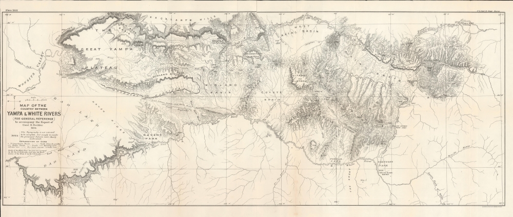

FOR THE ORIGINAL ANTIQUE MAP, WITH HISTORICAL ANALYSIS, CLICK HERE.
Digital Map Information
Geographicus maintains an archive of high-resolution rare map scans. We scan our maps at 300 DPI or higher, with newer images being 600 DPI, (either TIFF or JPEG, depending on when the scan was done) which is most cases in suitable for enlargement and printing.
Delivery
Once you purchase our digital scan service, you will receive a download link via email - usually within seconds. Digital orders are delivered as ZIP files, an industry standard file compression protocol that any computer should be able to unpack. Some of our files are very large, and can take some time to download. Most files are saved into your computer's 'Downloads' folder. All delivery is electronic. No physical product is shipped.
Credit and Scope of Use
You can use your digial image any way you want! Our digital images are unrestricted by copyright and can be used, modified, and published freely. The textual description that accompanies the original antique map is not included in the sale of digital images and remains protected by copyright. That said, we put significant care and effort into scanning and editing these maps, and we’d appreciate a credit when possible. Should you wish to credit us, please use the following credit line:
Courtesy of Geographicus Rare Antique Maps (http://www.geographicus.com).
How Large Can I Print?
In general, at 300 DPI, you should at least be able to double the size of the actual image, more so with our 600 DPI images. So, if the original was 10 x 12 inches, you can print at 20 x 24 inches, without quality loss. If your display requirements can accommodate some loss in image quality, you can make it even larger. That being said, no quality of scan will allow you to blow up at 10 x 12 inch map to wall size without significant quality loss. For more information, it is best consult a printer or reprographics specialist.
Refunds
If the high resolution image you ordered is unavailable, we will fully refund your purchase. Otherwise, digital images scans are a service, not a tangible product, and cannot be returned or refunded once the download link is used.
Gustavus R. Bechler (fl. c. 1856 - 1878) was a surveyor and cartographer best known for his work with the U.S. Geological and Geographical Survey of the Territories (USGGST), led by Ferdinand Vandeveer Hayden. He appears to have gotten his start producing maps of counties in Pennsylvania, New York, and Michigan. During the U.S. Civil War, he drew several impressive, large-scale maps of highlighting battles and campaigns. Virtually nothing is known of Bechler's biographical details, despite being one of the more prolific members of USGGST, acting as chief topographer on Hayden's expedition to Yellowstone. The scant notes referring to him by other members of the survey suggest that he was skilled but difficult to work with. The Bechler River in Yellowstone National Park is named for him. More by this mapmaker...
George B. Chittenden (December 25, 1849 - February 24, 1939) was a topographer and surveyor who worked for the U.S. Geological and Geographical Survey of the Territories, precursor to the U.S. Geological Survey. Born and raised in Connecticut, Chittenden attended Yale University and trained as a civil engineer. Upon graduation, he joined the U.S. Geological and Geographical Survey of the Territories and from 1873 to 1876 surveyed the Colorado Territory. In 1877, he surveyed portions of the Wyoming and Idaho Territories. Soon afterwards, he was diagnosed with rheumatism, precluding further fieldwork in the American West. Instead, he and his brother established an engineering firm in Washington, D.C. Learn More...
Ferdinand Vandeveer Hayden (September 7, 1829 - December 22, 1887) was an American geologist remembered for leading late 19th century pioneering surveying expedition in the Rocky Mountains and served as a doctor in the Union Army during the U.S. Civil War. Born in Westfield, Massachusetts, and discovered a fascination with nature and wildlife in his youth. He studied at Oberlin College and graduated in 1850, then attended the Albany Medical College and earned his degree in 1853. While at Albany, Hayden garnered the attention of Professor James Hall, then the state geologist of New York. Professor Hall convinced Hayden to join an expedition to the Nebraska Territory, where he collected fossils and studied geology. He accompanied expeditions led by Gouverneur K. Warren in 1856 and 1857 and the Raynolds Expedition of 1860 led by Captain William F. Raynolds. He served as an army surgeon during the U.S. Civil War and rose to become the chief medical officer of the Army of the Shenandoah. After the war, Hayden resumed working on geologic and geographic surveys in the Nebraska and Western Territories and was appointed geologist-in-chief of the United States Geological and Geographical Survey of the Territories in 1867. Hayden led the first federally funded geological survey into the Yellowstone Region in northwestern Wyoming in 1871 under orders from Secretary of the Interior Columbus Delano. The expedition included fifty men, including painter Thomas Moran and Civil War photographer William Henry Jackson. Hayden's report on the expedition, Preliminary Report of the United State Geological Survey of Montana and Portions of Adjacent Territories; Being a Fifth Annual Report of Progress played an instrumental role in persuading Congress to establish Yellowstone as the first U.S. National Park. Learn More...
American Photo-Lithographic Company (1866 - c. 1884) was a Brooklyn, New York based lithography house active in the late 19th century. By the 1870s they had relocated to Fulton Street, in Manhattan. Early on, the firm was best known for its use of the Osborne Process, an economical photo-mechanical technique for making lithographic plates invented by Irish-Australian John Walter Osborne (1828 - 1902). Osborne may have been the owner or one of the co-founders of the American Photo-Lithographic Company, as he certainly had moved to New York City by this time to market his technique. He is known to have worked for the American Photo-Lithographic Company in both New York and Washington D.C - but the relationship remains unclear. Later the embraced other more advanced printing techniques. By 1877, the firm opened an annex office in Boston under Clement Drew, which it retained until 1879. We have identified no work by the American Photo-Lithographic Company postdating 1884. The firm should not be confused with the American Lithographic Company, which was founded by 1892. Learn More...
The United States Geological Survey (1878 - Present), aka the U.S.G.S., is a scientific agency of the United States government, which was founded in 1879. USGS scientists study the landscape of the United States, its natural resources, and the natural hazards that threaten it. The organization has four major science disciplines: biology, geography, geology, and hydrology. It is a bureau of the United States Department of the Interior and is the department's only scientific agency. Learn More...
Copyright © 2025 Geographicus Rare Antique Maps | Geographicus Rare Antique Maps
This copy is copyright protected.
Copyright © 2025 Geographicus Rare Antique Maps