This copy is copyright protected.
Copyright © 2025 Geographicus Rare Antique Maps
Digital Image: 1858 Holley Lithograph of 'Young America' Steam Locomotive
YoungAmerica-holley-1858_d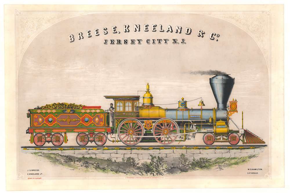


FOR THE ORIGINAL ANTIQUE MAP, WITH HISTORICAL ANALYSIS, CLICK HERE.
Digital Map Information
Geographicus maintains an archive of high-resolution rare map scans. We scan our maps at 300 DPI or higher, with newer images being 600 DPI, (either TIFF or JPEG, depending on when the scan was done) which is most cases in suitable for enlargement and printing.
Delivery
Once you purchase our digital scan service, you will receive a download link via email - usually within seconds. Digital orders are delivered as ZIP files, an industry standard file compression protocol that any computer should be able to unpack. Some of our files are very large, and can take some time to download. Most files are saved into your computer's 'Downloads' folder. All delivery is electronic. No physical product is shipped.
Credit and Scope of Use
You can use your digial image any way you want! Our digital images are unrestricted by copyright and can be used, modified, and published freely. The textual description that accompanies the original antique map is not included in the sale of digital images and remains protected by copyright. That said, we put significant care and effort into scanning and editing these maps, and we’d appreciate a credit when possible. Should you wish to credit us, please use the following credit line:
Courtesy of Geographicus Rare Antique Maps (http://www.geographicus.com).
How Large Can I Print?
In general, at 300 DPI, you should at least be able to double the size of the actual image, more so with our 600 DPI images. So, if the original was 10 x 12 inches, you can print at 20 x 24 inches, without quality loss. If your display requirements can accommodate some loss in image quality, you can make it even larger. That being said, no quality of scan will allow you to blow up at 10 x 12 inch map to wall size without significant quality loss. For more information, it is best consult a printer or reprographics specialist.
Refunds
If the high resolution image you ordered is unavailable, we will fully refund your purchase. Otherwise, digital images scans are a service, not a tangible product, and cannot be returned or refunded once the download link is used.
Alexander Lyman Holley (July 30, 1832 - January 29, 1882) was an American mechanical engineer. Born in Lakeville, Connecticut, Holley entered Williams Academy in Stockbridge, Massachusetts, in 1848, and then attended Brown University, from which he graduated in 1853 where 'he took the regular degree of the scientific course'. Per the New York City Parks Department biography (a memorial to Holley stands in Washington Square Park) Holley was the first person to graduate from Brown in engineering, receiving a bachelor of philosophy. Holley went to work in the locomotive department of the works of G.H. Corliss and Nightingale (later the Corliss Steam Engine Works) as a workman and a student. He spent three years in Providence and took full advantage of his time there, learning everything his position offered to teach him. He left Corliss in 1857 to become a locomotive engineer on the Stonington and Providence Railroad, a job he held for a year. The following year (1858), Holley met Zerah Colburn, the founder of Railway Advocate and London Engineering, and Holley began writing professionally, alongside his work as a mechanic and draughtsman. Also in 1858, Holley joined the 'New York Locomotive Works' of Breese, Kneeland and Company in Jersey City, New Jersey. Per an obituary in the February 18, 1882, edition of American Machinist
While employed at Jersey City, he made the first colored and shaded drawing ever made in those works. It was of the locomotive 'America' and was noticeably finer than the lithographs subsequently made from it, eliciting the war admiration of every mechanic who saw it.Holley and Colburn went to Europe in 1859 (it is unclear if Holley had left the employ of the new York Locomotive Works at this point in time) as commissioners sent by the presidents of the leading American railroads to study the technical conditions of European railroads which produced 'The Permanent Way, and Coal-burning Locomotive Boilers of European Railways'. Holley also wrote for the New York Times in 1858 and 1859 and became a special correspondent for the Times in London in 1859. He returned to London once again in 1860 to cover the final construction phases and the maiden voyage of the Great Eastern (a huge side-wheel steamship). During the Atlantic crossing, Holley penned a letter to the times in which he predicted that screw propellers were soon supersede sidewheels. Holley was sent to Europe again in 1862, this time to study European ordnance and armor for Edwin A. Stevens, and subsequently published a book on the subject called 'Treatise on Ordnance and Armor'. During this trip to England Holley met Henry Bessemer (later Sir Henry Bessemer) who developed the Bessemer steel process. Holley learned the processed and upon returning to the United States obtained control of Bessemer's American patents. With this victory, secured in 1864, Holley became forever linked with Bessemer steel. This link pushed him to be involved in the establishment in one way or another of a series of steel works across the eastern United States. Holley also made improvements to the Bessemer process, including the resulting Holley vessel bottom, a modification that was used in all American works. He lectured at the Columbia College School of Mines and was a professor at Stevens College of Technology beginning in 1872. Holley was active in many professional engineering organizations and was President of the American Institute of Mining Engineers in 1875. He was in London with his family in the summer of 1881 when he became seriously ill for 'about ten weeks' and was finally ordered by his doctors to return to the United States. Unfortunately, he had to return without his wife and two adult daughters because one of his daughters was sick with typhoid fever. Upon reaching New York, his health did not improve, and he died 'only ten minutes before the arrival of his wife and children'. More by this mapmaker...
Endicott and Company (fl. c. 1828 - 1891) was a New York based family run lithography firm that flourished throughout the 19th century. The firm was founded by George and William Endicott, brothers who were born in Canton, Massachusetts. George Endicott (June 14, 1802 - 1848) trained as a lithographer under Pendleton Lithography from January 1826. He later worked as superintendent of Senefelder Company until the summer of 1828. Afterwards, in 1830, he relocated to Baltimore and partnered with Moses Swett. Endicott and Swett relocated to New York City in December 1831. They remained partners until July 1834 when the relationship dissolved. George set up shop on his own account at 359 Broadway. William Endicott (1815 - 1851), George's younger brother of 14 years, joined the firm in 1840 and was made a partner in 1845, after which the name of the firm was changed to G. and W. Endicott. George Endicott died shortly afterward, in 1848, but William continued operating the firm as William Endicott and Co. until his own 1851 death at just 35 years old. The firm was carried on by his widow Sara Munroe Endicott until it was taken over by her son, Francis Endicott, who ran the firm from 1852 to 1886. George Endicott, Jr. subsequently ran the firm from 1887 to 1891. Peters, in his important work on American lithography America on Stone writes 'it is hard to summarize the Endicotts. They did everything and did it well . . . [they] worked with and for Currier and Ives, yet in spite of all that much of their work lacks real individuality.' The Endicott firm was responsible for many 19th century views and plans of New York City and state as well as plans of Sacramento, California, and the Midwest. Learn More...
Copyright © 2025 Geographicus Rare Antique Maps | Geographicus Rare Antique Maps
This copy is copyright protected.
Copyright © 2025 Geographicus Rare Antique Maps