Digital Image: 1930 Stacy Wood Map of 'Your Estate'
YourEstate-wood-1930_d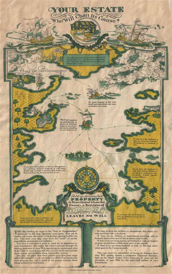

Title
Your Estate Who Will Chart Its Course. / A Map Showing How Property is Distributed when the Owners - a Resident of Massachusetts Leaves no Will.
1930 (dated) 17 x 10.5 in (43.18 x 26.67 cm)
1930 (dated) 17 x 10.5 in (43.18 x 26.67 cm)
Description
FOR THE ORIGINAL ANTIQUE MAP, WITH HISTORICAL ANALYSIS, CLICK HERE.
Digital Map Information
Geographicus maintains an archive of high-resolution rare map scans. We scan our maps at 300 DPI or higher, with newer images being 600 DPI, (either TIFF or JPEG, depending on when the scan was done) which is most cases in suitable for enlargement and printing.
Delivery
Once you purchase our digital scan service, you will receive a download link via email - usually within seconds. Digital orders are delivered as ZIP files, an industry standard file compression protocol that any computer should be able to unpack. Some of our files are very large, and can take some time to download. Most files are saved into your computer's 'Downloads' folder. All delivery is electronic. No physical product is shipped.
Credit and Scope of Use
You can use your digial image any way you want! Our digital images are unrestricted by copyright and can be used, modified, and published freely. The textual description that accompanies the original antique map is not included in the sale of digital images and remains protected by copyright. That said, we put significant care and effort into scanning and editing these maps, and we’d appreciate a credit when possible. Should you wish to credit us, please use the following credit line:
Courtesy of Geographicus Rare Antique Maps (http://www.geographicus.com).
How Large Can I Print?
In general, at 300 DPI, you should at least be able to double the size of the actual image, more so with our 600 DPI images. So, if the original was 10 x 12 inches, you can print at 20 x 24 inches, without quality loss. If your display requirements can accommodate some loss in image quality, you can make it even larger. That being said, no quality of scan will allow you to blow up at 10 x 12 inch map to wall size without significant quality loss. For more information, it is best consult a printer or reprographics specialist.
Refunds
If the high resolution image you ordered is unavailable, we will fully refund your purchase. Otherwise, digital images scans are a service, not a tangible product, and cannot be returned or refunded once the download link is used.
Cartographer
Stacy H. Wood (November 25, 1887 - June 10, 1942) was an American children's book illustrator and graphic artist active in New York during the first half of the 20th century. Wood was born in Brooklyn and studied art at Amherst, the Pratt Institute and the Art Institute of Chicago. In Chicago, he met and married Alma F. Hewes. He was the owner of the Harbor Press. He created several pictorial maps including an allegorical estate planning map for Harris Forbes Trust (1930), a map of 'Zeeview (1930), a map of the travels of Count Francesco Arese (1934), pictorial map of the United States for the Boy Scouts of America Jamboree (1935), a map of the Poundridge Reservation (1935), a comic map of the United States (1936), and undated map of Forest Hills Gardens. In addition to his illustration work, Wood was active with the Boy Scouts of America as a Scout Master. Wood's father was Henry Firth Wood, a well-known orator and friend to financiers James Fisk and Jay Gould. More by this mapmaker...