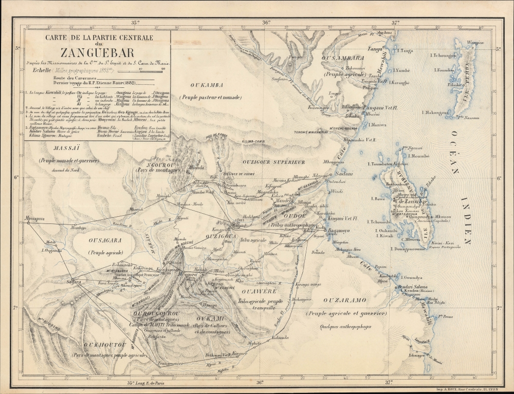
1882 Roux Map of East Africa Coast, Zanzibar, Tanzania
Zanguebar-roux-1882$400.00

Title
Carte de la partie centrale du Zanguebar d'après les Missionnaires de la Con. du St. Esprit et du St. Coeur de Marie.
1882 (undated) 11.5 x 15 in (29.21 x 38.1 cm) 1 : 1075000
1882 (undated) 11.5 x 15 in (29.21 x 38.1 cm) 1 : 1075000
Description
A curious missionary map of eastern Africa around Zanzibar and the opposite coast of the mainland, corresponding to the northern coast of Tanzania, printed in 1882 by A. Roux, covering the territory where the Catholic order of the Holy Ghost Fathers operated.
Etienne Baur played a central role in the history of the mission and the early interactions between Europeans and peoples in the interior regions of the Swahili Coast. Arriving in Zanzibar in 1863, Baur and several of his confreres set about learning Swahili (Baur translated the catechism into that language) and making exploratory forays into the African interior (he reached Kilimanjaro in 1884). Being an Alsatian, Baur was well positioned to negotiate between warring parties during the Abushiri Revolt (1888-1889), when the German government suppressed a revolt against a clumsy attempt by the Deutsch-Ostafrikanische Gesellschaft to seize control of Zanzibar.
A Closer Look
The map covers much of today's northeastern Tanzania along with Zanzibar. Settlements, caravan routes, mountains, waterways, and various ethnic groups are labeled, often with brief, colorful descriptors, with a couple being described as 'anthropophages,' that is, cannibals. The map includes significant linguistic and anthropological information, including a glossary of Swahili terms in the title box and the names of multiple local chiefs. A dotted line traces the 1882 travels of Father Etienne Baur, the Apostolic Prefect of Zanzibar and a member of the Congrégation du Saint-Esprit et du Saint-Cœur-De-Marie, more commonly known as the Holy Ghost Fathers or the Spiritans. This Roman Catholic order focused its missionary efforts on Africa, especially West Africa, but also had several missions in eastern AfricaProselytizing the Swahili Coast
The Spiritans were one of the main Roman Catholic religious orders operating in eastern Africa, the other being the 'White Fathers' (Missionaries of Africa). The missionaries faced a wide range of challenges, from disease and hostility from local adherents of Islam and local folk religions to opposition from Protestant missionaries to getting embroiled in local political issues. In particular, the missionaries had to maintain a good relationship with the Sultan of Zanzibar, which was the main hub for travel and logistics in the region, while also maintaining their commitment to opposing slavery, which was prevalent in Zanzibar and one source of the Sultan's wealth. (Zanzibar was the largest slave market in the world at the time.)Etienne Baur played a central role in the history of the mission and the early interactions between Europeans and peoples in the interior regions of the Swahili Coast. Arriving in Zanzibar in 1863, Baur and several of his confreres set about learning Swahili (Baur translated the catechism into that language) and making exploratory forays into the African interior (he reached Kilimanjaro in 1884). Being an Alsatian, Baur was well positioned to negotiate between warring parties during the Abushiri Revolt (1888-1889), when the German government suppressed a revolt against a clumsy attempt by the Deutsch-Ostafrikanische Gesellschaft to seize control of Zanzibar.
Publication History and Census
This map was likely prepared by the Spiritans themselves and printed by Imprimerie Roux, a printer of other missionary maps. It appeared in the 1882 volume of Les Missions catholiques, revue générale illustrée de toutes les missions. The map is only independently cataloged among the holdings of the University of California Santa Barbara, the Staatsbibliothek zu Berlin, and the Universiteit Antwerpen. The full volume of Les Missions catholiques is more widely distributed.Source
Les Missions catholiques : revue générale illustrée de toutes les missions, Vol. 13, (Lyon: Oeuvre de la propagation de la foi) 1882.
Condition
Very good. Old binding strip on verso. Very close bottom margin. A couple small pencil annotations.
References
OCLC 1029056810, 902293791.

