This item has been sold, but you can get on the Waitlist to be notified if another example becomes available, or purchase a digital scan.
1918 World War I Anti-Britain German-issued Spanish-language Propaganda Map of the World
ZarpaBritanica-haase-1918-2$1,750.00


Title
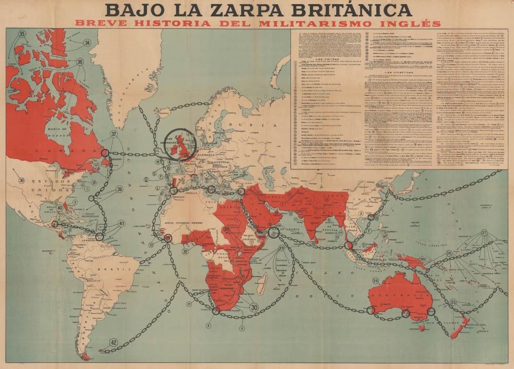
Bajo la Zarpa Británica, Breve historia del militarismo inglés.
1918 (undated) 30.5 x 42.5 in (77.47 x 107.95 cm) 1 : 30000000
1918 (undated) 30.5 x 42.5 in (77.47 x 107.95 cm) 1 : 30000000
Description
A fascinating 1918 German-issued Spanish-language World War I broadsheet propaganda map representing the world wrapped in the chains of British militantism and colonialism. Issued by F. Haase, this map was part of the WWI propaganda war waged by both the Allies and Central powers to sway the hearts and minds of neutral nations.
German Response to 'What Germany Wants'
This map was published in response to the 1917 British map 'What Germany Wants' (Mode 1199.01) - which this map mirrors in style, typography, design, and coloration. Unlike the British map, which was printed in England and translated into various languages for distribution in neutral countries, this German response map was printed exclusively in Spain in only small quantities and is consequently far more ephemeral. Where the British map outlines German imperial ambitions, this German response highlights existing British colonial claims. It denounces the British colonies and protectorates as 'open wounds' ('heridas abiertas') and 'poorly closed scars' ('cicatrices mal cerradas').Wounds and Scars
Blood red ink highlights the British sphere of influence with some 40 locations numerically identified as 'wounds'. These include Cyprus, Malta, Australia, India, Nigeria, and the Falkland Islands. The 'scars' refer to British wars and conflicts, beginning as early as 1070 and extending to the 1904 War in Tibet. A lion paw representing England holds chains tethering the world. In rough translation from the map:In the claws of the British. A brief history of English militarism. The claws of England, subtly gloved in sheepskin to deceive its intentions, have recently manufactured, and distributed a 'Mapa Mundi' throughout Spain, in which Germany's claims to the enormous regions of the world which, here, happen to be printed red, without further supporting argument than a few captions, taken from information provided by the Pangermanists. Naturally these Pangermanists are not synonymous with Germany, whose government and people do not support their aims, who in fact have no desire to suffer the excesses of such excitable patriots and, above all bearing in mind the fact that dreams like these are not and could never constitute a viable reality. Therefore the proposition on which the English map is founded is baseless.
Conversely, the world is not deceived by what is shown and written here! We are not propounding fantasies here: these are the bloody deeds, open wounds and poorly-healed scars, that occur as a result of Britain slashing its way across the world, turning the seas red, turning whole populations into slaves.
To make things simpler to understand, we'll divide these arguments into two halves: one geographical, using numbers to indicate just about everything we need to cover (the sum total doesn't even fit into the English 'Mapa Mundi,' the outlines and measurements of which we have used here; it overflows the margins and even overwrites them!), everywhere Great Britain rules today, in terms of its non-English lands and peoples. Secondly historical, using letters to indicate those regions of the world where England in earlier times subjected whole peoples by dint of cunning, or where it scored the stigma of its dominion by means of steel and firepower.
Spain during World War I
Spain officially maintained neutrality throughout World War I (1814 - 1918). Although Spanish citizens were asked to remain neutral, the nation was plagued by divisiveness. The army, bourgeoisie, aristocracy, and the Catholic Church identified with Germany and favored the Central Powers. Spanish Republicans, Socialists, Liberals, and the middle and professional classes were overwhelmingly pro-Allies. This division, along with Spain's strategic location between the Mediterranean and the Atlantic, made it an unofficial propaganda battleground.Foreign Influence and Propaganda in Spain during World War I
While Spain's neutrality was meant to keep it free of direct conflict, both the Allies and the Central Powers were active in industrial sabotage plots, political and commercial sabotage, and an aggressive propaganda war. Both sides hoped to convert popular opinion to their side and pursued their goals through film showings, leaflets, posters, and journalistic grants, among other means. Britain and France, with close pre-war commercial ties to Spain, generally resorted to more subtle propaganda. However, the Central Powers, with little to lose and much to gain, waged an intensive brutalistic propaganda campaign.Publication History and Census
This map was published by F. Haase for distribution in Spain. Haase has proven annoyingly elusive. He appears to have operated in Spain during World War I, mostly issuing pro-Germany propaganda materials. He may have later emigrated to the United States where, if it is the same individual, he issued several other pictorial maps in the late 1940s. Three examples of this map are cataloged in OCLC: the New York Public Library, the Staatsbibliothek zu Berlin, and the Deutsche Nationalbibliothek Leipzig. We also note an example at the Imperial War Museum.Condition
Good. Wear along original fold lines. Areas of infill along original fold lines. Closed margin tears professionally repaired on verso. Some foxing.
References
Imperial War Museum: Art.IWM PST 6913. OCLC 1298674978, 719049637. c.f. Cornell University Library, P. J. Mode Collection of Persuasive Maps, 1199.01.