This item has been sold, but you can get on the Waitlist to be notified if another example becomes available, or purchase a digital scan.
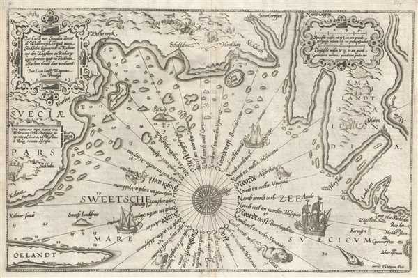
1583 Waghenaer Nautical Chart of Coast of Sweden
ZeeCustevanSweeden-waghenaer-1583$1,000.00

Title
Zee Custe van Sweeden, otrent de Westernÿck en tgatt vann Stockholm, beginnende va Kalmar tot den Wigsteen en Rookoe gelegen bynnenn tgatt va Stockholm alfoe hem tlandt daer verthoont
1583 (dated) 21 x 14 in (53.34 x 35.56 cm)
1583 (dated) 21 x 14 in (53.34 x 35.56 cm)
Description
This 1583 nautical chart or maritime map of Sweden along the Swedish Sea was produced by Lucas Janszoon Waghenaer. This chart is oriented to the west-northwest and depicts the coastline from Kalmar and Öland (Oelandt) in the southwest to the route to Stockholm in the northwest. Along the coastline myriad islands are depicted to aid mariners with navigation as well as depth soundings. Safe harbors are depicted using anchors at several locations, including Fluerbuÿ, Westernÿck, Sylbuÿand and Honssbaÿ. These towns are depicted using buildings so that each town could be identified while at sea and farm land is illustrated as well. This chart incorporates an exceedingly intricate compass rose in the center with 32 labeled compass headings. The chart includes depictions of fish, sea creatures, and sailing ships in the sea. On land, forests and mountains are drawn in profile. A bear, a goat, a fox and a wolf also appear on the chart, giving the appearance of vast, untamed wilderness surrounding the coastal villages. Two decorative cartouches are present, containing respectively the title and scale. This chart is remarkably rare. There are no examples appearing in known institutional collections or recorded examples on the market.
Wagehenaer published
Spieghel Der Zeevaerdt was the first published nautical atlas and became an immediate success. Partially based on Waghenaer's observations as a navigation officer and partially on his vast experience in practical navigation methods, Spieghel Der Zeevaerdt combines text, which is based on traditional 16th century navigation publications, and charts which makes this the world's first published pilot guide. This atlas was printed in folio format, an innovation for the time, and was eventually printed in Dutch, French, English, German, and several other languages. Waghenaer eventually published several other editions of his pilot guides, which were smaller and more practical, particularly with mariners as the large folio editions were difficult to use onboard ship Although this chart is dated 1583, it is difficult to know for certain if this chart comes from an edition of Spieghel Der Zeevaerdt or one of the later editions, since it is smaller in size and uncolored. We have not been able to personally examine a copy of Spieghel Der Zeevaerdt to verify that it appears in the 1586 edition.
Cartographer
Lucas Janszoon Waghenaer (c. 1533 - 1606) was a Dutch cartographer born in Enkhuizen. He was one of the founding members of the North Holland school of cartography, as well as one of its most famous proponents. The North Holland school played a major role in the early development of Dutch nautical chart-making. More by this mapmaker...
Source
Waghenaer, Lucas Janzoon, Spieghel Der Zeevaerdt
Spieghel Der Zeevaerdt was the first published nautical atlas and became an immediate success. Partially based on Waghenaer's observations as a navigation officer and partially on his vast experience in practical navigation methods, Spieghel Der Zeevaerdt combines text, which is based on traditional 16th century navigation publications, and charts which makes this the world's first published pilot guide. This atlas was printed in folio format, an innovation for the time, and was eventually printed in Dutch, French, English, German, and several other languages. Waghenaer eventually published several other editions of his pilot guides, which were smaller and more practical, particularly with mariners as the large folio editions were difficult to use onboard ship.
Condition
Very good. There is some slight transference.

