This copy is copyright protected.
Copyright © 2025 Geographicus Rare Antique Maps
1570 / 1587 Ortelius and Van Deventer map of Zeeland, The Netherlands
Zeeland-ortelius-1570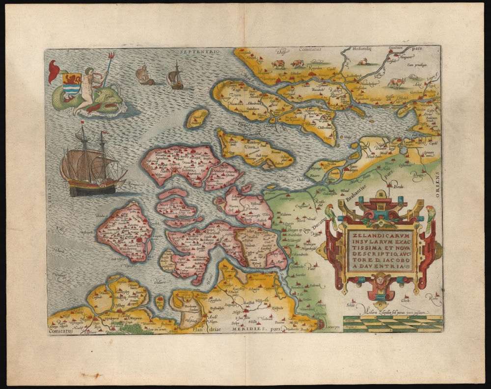


Abraham Ortelius (April 14, 1527 - June 28, 1598) also known as Ortels, was a cartographer, geographer, and cosmographer of Brabant, active in Antwerp. He was the creator of the first modern atlas, Theatrum Orbis Terrarum and is a seminal figure in the history of cartography. Along with Gerard Mercator and Gemma Frisius, he was a founder of the Netherlandish school of cartography. His connections with Spain - culminating in his 1575 appointment as Royal Cartographer to King Phillip II of Spain - gave him unmatched access to Spanish geographical knowledge during a crucial period of the Age of Discovery. Ortelius was born in 1527 in Antwerp. In 1547 he entered the Antwerp Guild of Saint Luke as an illuminator of maps. He began trading in books, prints, and maps, traveling regularly to the Frankfurt book and print fair, where in 1554 he met Mercator. He accompanied Mercator on journeys throughout France in 1560 and it was at this time, under Mercator's influence, that he appears to have chosen his career as a scientific geographer. His first published geographic work appeared in 1564, an eight-sheet cordiform world map. A handful of other maps preceded the 1570 publication of the first edition of the Theatrum Orbis Terrarum, which would prove to be his life work. Appearing with but 53 maps in its first edition, Ortelius' work expanded with new maps added regularly. By 1592, it had 134 maps. Many of Ortelius' maps remained the standard for nearly a century. He traveled extensively, but his genius was as a compiler, locating the best informed maps on which to base his own. His contacts throughout Europe and extending even (via the Portuguese) to the Far East were formidable. Moreover, many of his maps were based on his own scholarship, particularly his historical works. His theories of geography were particularly ahead of his time with respect to the notion of continental drift, the possibility of which he mused on as early as 1596, and which would be proven correct centuries later.
In a sense his greatest achievement was his successful navigation of the religious and political violence endemic to his city throughout his adult life: The Dutch Revolt, or Eighty Years' War (1568 - 1648), fully embroiled Antwerp. Although outwardly and officially recognized as Catholic (Arias Montanus vouched for Ortelius' Catholic orthodoxy prior to his appointment as Royal Geographer), Ortelius was able to separate himself from the religious furor which characterized the war in the low countries. Ortelius showed a glimpse of himself in a letter to a friend, regarding humanist Justus Lipsius: 'I do not know whether he is an adherent of the Pope or a Calvinist, but if he has ears to hear, he will neither be one nor the other, for sins are committed on both sides'. Ortelius' own explorations of Biblical history in his maps, and the Christogram contained in his own motto, suggest him to be a religious man, but his abjuration of political religious authorities mark him as an individualist. His tombstone at St Michael's Præmonstratensian Abbey in Antwerp bears the inscription, Quietis cultor sine lite, uxore, prole. ('served quietly, without accusation, wife, and offspring.') More by this mapmaker...
Jacob van Deventer (c. 1500/1505 - 1575) was a Dutch cartographer, best known for his systematic mapping of the Netherlands, making use of modern trigonometric methods. Little is known about his youth or training. He was born in Kampen, and probably was raised in a Catholic family. He enrolled at the University of Leuven in 1520. Despite beginning his studies in medicine and philosophy, he would later develop a focus on geography and mapmaking. With the advent of the Dutch Revolt, he relocated to Cologne; he would eventually serve the Spanish as Royal Cartographer.
He was one of the first mapmakers to understand and employ Gemma Frisius' techniques of triangulation in producing maps. In 1536 he produced his first printed map of Brabant; from 1559 on he would begin mapping all the cities of the Netherlands on behalf od King Philip II of Spain; for the most part these were not published, being sequestered by the Spanish for military use. His maps of the Dutch provinces would however find their way to print in the atlases of Ortelius, De Jode and others.
Learn More...
Joannes van Doetecum the Elder (1530 - 1605) was a Dutch engraver and cartographer, known for his etchings after Breughel, and an array of maps engraved on his own behalf and that of an array of cartographers. He was born in Deventer, and moved to Haarlem in 1578. He was the start of a dynasty of Dutch map engravers whose work appears on the maps of Gerard De Jode, Abrahanm Ortelius, Jan van Linschoten, Plancius, Plantin, Waghanaer, Jansson, and Visscher. His engraver family included his brother Lucas (fl. 1558 - 1593,) and his sons Johannes II )(fl. 1592-1630) Peter, and Baptista. Despite their prolific work, very little is known about the Doetecum family. Learn More...
Copyright © 2025 Geographicus Rare Antique Maps | Geographicus Rare Antique Maps
This copy is copyright protected.
Copyright © 2025 Geographicus Rare Antique Maps