This copy is copyright protected.
Copyright © 2025 Geographicus Rare Antique Maps
Digital Image: 1561 / 1564 Ruscelli Edition of Nicolo Zeno's Map of the North Atlantic
Zeno-ruscelli-1561-3_d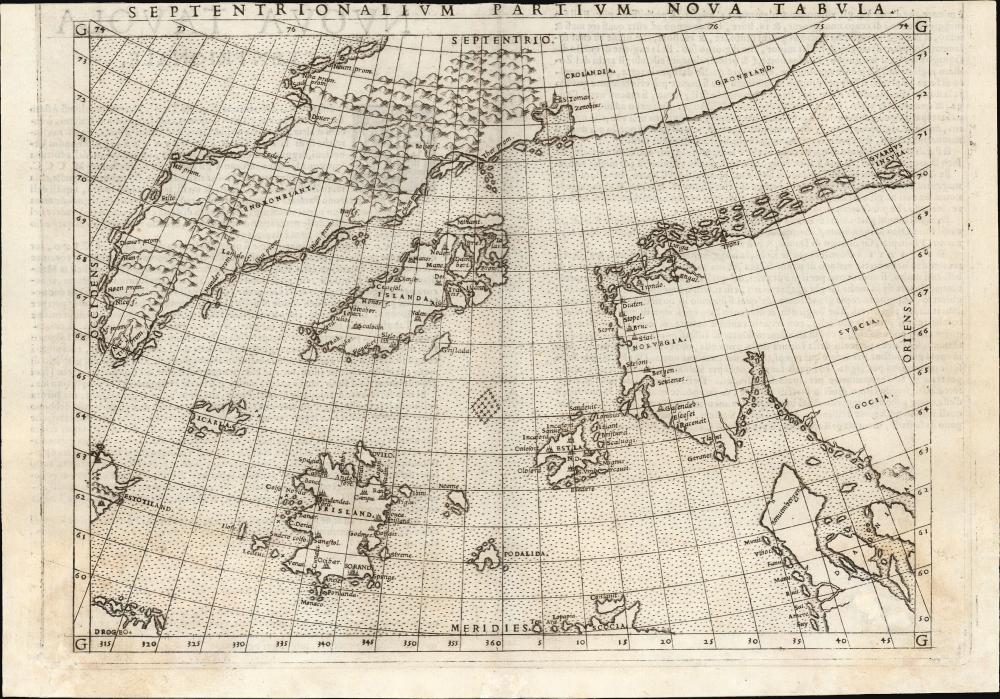


FOR THE ORIGINAL ANTIQUE MAP, WITH HISTORICAL ANALYSIS, CLICK HERE.
Digital Map Information
Geographicus maintains an archive of high-resolution rare map scans. We scan our maps at 300 DPI or higher, with newer images being 600 DPI, (either TIFF or JPEG, depending on when the scan was done) which is most cases in suitable for enlargement and printing.
Delivery
Once you purchase our digital scan service, you will receive a download link via email - usually within seconds. Digital orders are delivered as ZIP files, an industry standard file compression protocol that any computer should be able to unpack. Some of our files are very large, and can take some time to download. Most files are saved into your computer's 'Downloads' folder. All delivery is electronic. No physical product is shipped.
Credit and Scope of Use
You can use your digial image any way you want! Our digital images are unrestricted by copyright and can be used, modified, and published freely. The textual description that accompanies the original antique map is not included in the sale of digital images and remains protected by copyright. That said, we put significant care and effort into scanning and editing these maps, and we’d appreciate a credit when possible. Should you wish to credit us, please use the following credit line:
Courtesy of Geographicus Rare Antique Maps (http://www.geographicus.com).
How Large Can I Print?
In general, at 300 DPI, you should at least be able to double the size of the actual image, more so with our 600 DPI images. So, if the original was 10 x 12 inches, you can print at 20 x 24 inches, without quality loss. If your display requirements can accommodate some loss in image quality, you can make it even larger. That being said, no quality of scan will allow you to blow up at 10 x 12 inch map to wall size without significant quality loss. For more information, it is best consult a printer or reprographics specialist.
Refunds
If the high resolution image you ordered is unavailable, we will fully refund your purchase. Otherwise, digital images scans are a service, not a tangible product, and cannot be returned or refunded once the download link is used.
Nicolò Zeno the Younger (1515–1565) was a Venetian Senator and author. He was the son of a literary man and a family powerful in Venetian politics, and was reputedly educated in science and the humanities. He was a successful hydraulic engineer, a most important field in so inundated a city as Venice. Able though he may have been, his early entrance to politics at the age of 23 was made possible via payments of 100 ducats to the Council of Ten. Following Venice's disastrous 1537-1540 war with the Ottoman Empire, Zeno wrote and published an unpublished history of the conflict notable for its invective against proponents of the war.
Zeno is mainly remembered for his 1558 publication of a map and series of letters which he claimed to have discovered in a storeroom of the family's home in Venice, purporting to describe a fourteenth century voyage by his ancestors, Nicolò and Antonio Zeno, to the north Atlantic and even to North America. Zeno's position as Senator would have discouraged question of his honesty in Venice, certainly, and the inclusion of his map in Ruscelli's successful 1561 edition of Ptolemy ensured the spread of his geographical ideas. And indeed, Zeno's map was widely accepted for over a century, influencing the maps of Ortelius, Mercator, Blaeu and others, until research (in particular that of Frederic W. Lucas, in 1898) identified both the cartographic and textual sources Zeno employed in concocting his report, demolishing its credibility.
More by this mapmaker...
Girolamo Ruscelli (1500 - 1566) was an Italian polymath, humanist, editor, and cartographer active in Venice during the early 16th century. Born in Viterbo, Ruscelli lived in Aquileia, Padua, Rome and Naples before relocating to Venice, where he spent much of his life. Cartographically, Ruscelli is best known for his important revision of Ptolemy's Geographia, which was published posthumously in 1574. Ruscelli, basing his work on Gastaldi's 1548 expansion of Ptolemy, added some 37 new "Ptolemaic" maps to his Italian translation of the Geographia. Ruscelli is also listed as the editor to such important works as Boccaccio's Decameron, Petrarch's verse, Ariosto's Orlando Furioso, and various other works. In addition to his well-known cartographic work many scholars associate Ruscelli with Alexius Pedemontanus, author of the popular De' Secreti del R. D. Alessio Piemontese. This well-known work, or "Book of Secrets" was a compilation of scientific and quasi-scientific medical recipes, household advice, and technical commentary on a range of topics that included metallurgy, alchemy, dyeing, perfume making. Ruscelli, as Alexius, founded a "Academy of Secrets," a group of noblemen and humanists dedicated to unearthing "forbidden" scientific knowledge. This was the first known experimental scientific society and was later imitated by a number of other groups throughout Europe, including the Accademia dei Secreti of Naples. Learn More...
Frederic W. Lucas (July 20, 1842 - May 13,1932) was a British solicitor and author. Born in Surrey, he was schooled at Brighton College, went to Cambridge, and became a solicitor in London where he worked in a family firm. Lucas was by discipline a historian of early exploration and an Americanist. While it is not known how disciplined a collector of maps he may have been - by family accounts he collected everything - his approach to the comparative study of maps appears to have been unmatched, and greatly aided by recent developments in the photography and printing, allowing him access to works of the greatest rarity that would previously have required years of travel to scrutinize. He published three books pertinent to the study of early maps, particularly of the Americas. The first represented a study of a 1763 map of North America etched on a powder horn. It is his 1898 book, however, which should excite the interest of every map enthusiast: The Annals of the Voyages of the Brothers Nicolo and Antonio Zeno in the North Atlantic about the end of the Fourteenth Century and the Claim founded thereon to a Venetian Discovery of America: A Criticism and an Indictment. The book represents the systematic and gleeful destruction of centuries’ worth of arguments on behalf of the 1558 map and book of Venetian politician Nicolo Zeno the Younger, revealing the account to not be in error but to be a deliberate fraud. With particular care Lucas dismantled the arguments of Richard Henry Major (October 3, 1818 – June 25, 1891) curated the map collection of the British Museum from 1844 until his retirement in 1880 and whose book on the subject of the Zeno Brothers proposed not only that their voyages were genuine, but that they actually supported the idea that America was in visited by Henry Sinclair, Earl of Orkney. Lucas’ book carefully compared the information presented on the Zeno map and found it to have been a pastiche of published maps and travelogues accessible to the 16th century Zeno. Unfortunately for posterity, Lucas’ book (the work after all of an enthusiast) fell out of print, while that of Major (curator of an illustrious museum and member of the Hakluyt Society) remained in continuous publication by that society, to the detriment of a century’s scholarship and permitting the spurious Sinclair narrative to fuel tinfoil hat conspiracy theories regarding the pre-Columbian establishment of Knights Templars in North America.
His third book, The new laws of the Indies for the good treatment and preservation of the Indians, promulgated by the emperor Charles the Fifth, 1542-1543 consisting of a facsimile reprint of the original Spanish laws on the treatment of Native Americans, together with a literal translation into English. Learn More...
Copyright © 2025 Geographicus Rare Antique Maps | Geographicus Rare Antique Maps
This copy is copyright protected.
Copyright © 2025 Geographicus Rare Antique Maps