This copy is copyright protected.
Copyright © 2025 Geographicus Rare Antique Maps
Digital Image: 1796 Dalrymple / Barrow Map of Tchu-san (Zhoushan), China; Macartney Mission
Zhoushan-dalrymple-1796_d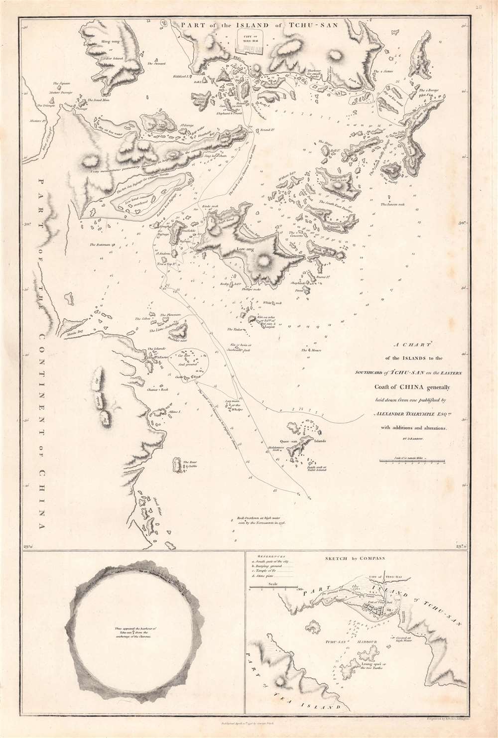

FOR THE ORIGINAL ANTIQUE MAP, WITH HISTORICAL ANALYSIS, CLICK HERE.
Digital Map Information
Geographicus maintains an archive of high-resolution rare map scans. We scan our maps at 300 DPI or higher, with newer images being 600 DPI, (either TIFF or JPEG, depending on when the scan was done) which is most cases in suitable for enlargement and printing.
Delivery
Once you purchase our digital scan service, you will receive a download link via email - usually within seconds. Digital orders are delivered as ZIP files, an industry standard file compression protocol that any computer should be able to unpack. Some of our files are very large, and can take some time to download. Most files are saved into your computer's 'Downloads' folder. All delivery is electronic. No physical product is shipped.
Credit and Scope of Use
You can use your digial image any way you want! Our digital images are unrestricted by copyright and can be used, modified, and published freely. The textual description that accompanies the original antique map is not included in the sale of digital images and remains protected by copyright. That said, we put significant care and effort into scanning and editing these maps, and we’d appreciate a credit when possible. Should you wish to credit us, please use the following credit line:
Courtesy of Geographicus Rare Antique Maps (http://www.geographicus.com).
How Large Can I Print?
In general, at 300 DPI, you should at least be able to double the size of the actual image, more so with our 600 DPI images. So, if the original was 10 x 12 inches, you can print at 20 x 24 inches, without quality loss. If your display requirements can accommodate some loss in image quality, you can make it even larger. That being said, no quality of scan will allow you to blow up at 10 x 12 inch map to wall size without significant quality loss. For more information, it is best consult a printer or reprographics specialist.
Refunds
If the high resolution image you ordered is unavailable, we will fully refund your purchase. Otherwise, digital images scans are a service, not a tangible product, and cannot be returned or refunded once the download link is used.
Alexander Dalrymple (July 24, 1737 - June 19, 1808) was a Scottish geographer and hydrographer active with East India Company and later as first Hydrographer to the British Admiralty. Dalrymple was born at Newhailes, near Edinburgh, Scotland, the 11th of 15 children of James Dalrymple and his wife, Christian Hamilton, the daughter of the Earl of Haddington. He joined the East India Company in 1752, at which point he was immediate sent to Madras, India. There he advocated for increased trade with the East Indies and China, negotiating a treaty with the Sultan of Sulu and visiting Canton (Guangzhou), China. He went on to develop an interest in historical voyages and navigation. In 1772, Dalrymple published his first set of charts, four of which were of the seas around Sulu. In 1779, he headed the hydrographic office of the East India Company, and that of the Admiralty in 1795. Dalrymple was instrumental in advancing the mapping of uncharted waters, particularly in the East Indies and the Pacific Ocean. He was an advocate for the existence of a large southern continent, Terra Australis, which influenced British exploration efforts. Dalrymple’s extensive work on nautical charts and navigational information significantly improved the safety and accuracy of sea voyages. His dedication to hydrography laid the groundwork for future maritime exploration. More by this mapmaker...
John Barrow (June 19, 1764 – November 23, 1848) was an English statesman, cartographer, and writer active in the late 18th and early 19th centuries. Barrow was born in the village of Dragley Beck, in Ulverston, Cumbria. His first recorded work was as a superintending clerk at a Liverpool iron foundry, but by his early 20s, transitioned to teaching mathematics at a private school in Greenwich. One of his pupils, the young son of Sir George Leonard Staunton, favored him and he was introduced to Lord George Macarteny. Barrow accompanied Macartney as a comptroller of household, on his 1792-1794, embassy to China. Having acquitted himself well, Barrow was hired by Macartney as private secretary on a political mission to the newly acquired Cape Colony, South Africa. Barrow was given the difficult task of reconciling Boer settlers with the indigenous African population. In the course of this voyage he traveled throughout the Cape Colony, coming to know that country well. There he married botanical artist Anna Maria Truter, and, in 1800, acquired a home with the intention of settling in Cape Town. Following the 1802 Peace of Amiens, the British surrendered the colony and Barrow returned to England where he was appointed Second Secretary to the Admiralty, a post he held with honor for the subsequent 40 years. In his position at the Admiralty Barrow promoted various voyages of discovery, including those of John Ross, William Edward Parry, James Clark Ross, and John Franklin. The Barrow Strait in the Canadian Arctic as well as Point Barrow and the city of Barrow in Alaska are named after him. He is reputed to have been the initial proposer of St Helena as the new place of exile for Napoleon Bonaparte following the Battle of Waterloo in 1815. He was a member of the Royal Society and the Raleigh Club, a forerunner of the Royal Geographical Society. In 1835 Sir Robert Peel conferred upon him a baronetcy. Learn More...
George Nicol (1740 - June 25, 1828) was a Scottish bookseller and publisher active in in 18th-century London. Nicol was born in Scotland, but relocated to London in 1769 to work with his uncle, the Strand bookseller David Wilson (17?? - 1777). The two eventually became full business partners, enjoying immense success. When Wilson died in 1777, Nichol took over the business in full. In 1781, Nicol was appointed official bookseller to King George III, a position he maintained until 1820. In 1787 he relocated to Pall Mall, acquiring 51 and 58 Pall Mall, one as a shop and the other as living quarters. Around 1800, his son George Nicol joined the firm, and it was renamed George and William Nicol. When the elder Nichol died in 1828, the firm continued as William Nicol until 1855. Learn More...
Benjamin Baker (1766 - June 29, 1841) was British engraver active in the late 18th and early 19th centuries. Baker was born in London, the son of instrument maker Edward Baker (1730 - 1797). As a young map he was apprenticed to Thomas Beresford, a watchmaker. This likely did not work out, as he was turned over to the engraver, mapmaker, and globemaker William Palmer (1739 - 1812). Baker rose to prominence as an engraver for the British Admiralty and British Ordnance Survey. In time he became the principal engraver for the Ordnance Survey, not only engraving himself, but overseeing the entire team of Ordnance engravers. His son, Benjamin Richard Baker (1792 - 1876) was also a mapmaker, engraver, draughtsman, lithographer, and printer. Learn More...
Copyright © 2025 Geographicus Rare Antique Maps | Geographicus Rare Antique Maps
This copy is copyright protected.
Copyright © 2025 Geographicus Rare Antique Maps