This copy is copyright protected.
Copyright © 2025 Geographicus Rare Antique Maps
Digital Image: 1890 San Antonio Aransas Pass Railway Map of Rockport, Corpus Christi, Texas
AransasCorpusChristiTX-millington-1905_d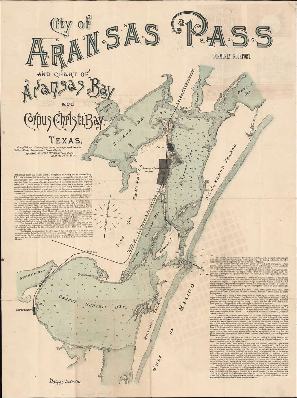

FOR THE ORIGINAL ANTIQUE MAP, WITH HISTORICAL ANALYSIS, CLICK HERE.
Digital Map Information
Geographicus maintains an archive of high-resolution rare map scans. We scan our maps at 300 DPI or higher, with newer images being 600 DPI, (either TIFF or JPEG, depending on when the scan was done) which is most cases in suitable for enlargement and printing.
Delivery
Once you purchase our digital scan service, you will receive a download link via email - usually within seconds. Digital orders are delivered as ZIP files, an industry standard file compression protocol that any computer should be able to unpack. Some of our files are very large, and can take some time to download. Most files are saved into your computer's 'Downloads' folder. All delivery is electronic. No physical product is shipped.
Credit and Scope of Use
You can use your digial image any way you want! Our digital images are unrestricted by copyright and can be used, modified, and published freely. The textual description that accompanies the original antique map is not included in the sale of digital images and remains protected by copyright. That said, we put significant care and effort into scanning and editing these maps, and we’d appreciate a credit when possible. Should you wish to credit us, please use the following credit line:
Courtesy of Geographicus Rare Antique Maps (http://www.geographicus.com).
How Large Can I Print?
In general, at 300 DPI, you should at least be able to double the size of the actual image, more so with our 600 DPI images. So, if the original was 10 x 12 inches, you can print at 20 x 24 inches, without quality loss. If your display requirements can accommodate some loss in image quality, you can make it even larger. That being said, no quality of scan will allow you to blow up at 10 x 12 inch map to wall size without significant quality loss. For more information, it is best consult a printer or reprographics specialist.
Refunds
If the high resolution image you ordered is unavailable, we will fully refund your purchase. Otherwise, digital images scans are a service, not a tangible product, and cannot be returned or refunded once the download link is used.
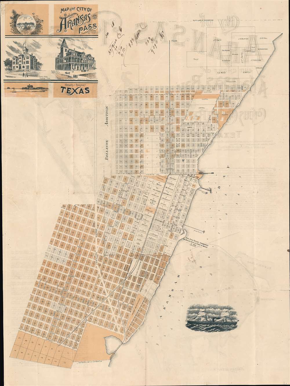
Thomas H. Millington (1819 - 1888) was an English-American civil and railroad engineer active in South Texas in the late 19th century. Millington was born in Prees, Shropshire, England. While it is not clear when he emigrated to the United States, he is recorded as a railroad engineer with the Nashville and Northwestern Railroad in 1856. He served the Confederate cause in the American Civil War, attaining the rank of colonel in charge of fortifications under General Pierre Gustave Toutant-Beauregard (1818 - 1893). After the war, he became chief engineer of the Memphis and Knoxville Railroad. Working with various railroad lines, Millington played a significant role in planning numerous railroad towns in the American southwest. Millington Tennessee is named after him. He was also briefly chief civil engineer for San Antonio, Texas. Four of his sons, George H Millington (1848 - 1931), Charles Alfred Millington (1850 - 1923), Joseph Millington (1852 - ????), and Frederick Alfred Millington (1853 - 1939) were also civil engineers. More by this mapmaker...
Dallas Lithograph Company (1883 - 1901) was a commercial lithography and chromolithography firm active in Dallas, Texas in the late 19th century. When founded in 1883 or 1884, it was the first lithographic press in Dallas. The founders were Isaac Monteaux, J. Booker, Nate Starke, and Thomas L Townsend (1851 - 19??). The company incorporated in 1885. They were early adaptors to the Steam Lithographic Press, capable of issuing large-scale lithographs in color and quantity. In 1890 they build an impressive three-story building at 176 Elm Street. In 1901 the firm was acquired by the Exline Printing Company. Learn More...
Copyright © 2025 Geographicus Rare Antique Maps | Geographicus Rare Antique Maps
This copy is copyright protected.
Copyright © 2025 Geographicus Rare Antique Maps