This copy is copyright protected.
Copyright © 2025 Geographicus Rare Antique Maps
Digital Image: 1890 W. H. Whitney / Henry Jackson Map of Astoria
Astoria-whitney-1890_d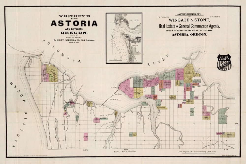

FOR THE ORIGINAL ANTIQUE MAP, WITH HISTORICAL ANALYSIS, CLICK HERE.
Digital Map Information
Geographicus maintains an archive of high-resolution rare map scans. We scan our maps at 300 DPI or higher, with newer images being 600 DPI, (either TIFF or JPEG, depending on when the scan was done) which is most cases in suitable for enlargement and printing.
Delivery
Once you purchase our digital scan service, you will receive a download link via email - usually within seconds. Digital orders are delivered as ZIP files, an industry standard file compression protocol that any computer should be able to unpack. Some of our files are very large, and can take some time to download. Most files are saved into your computer's 'Downloads' folder. All delivery is electronic. No physical product is shipped.
Credit and Scope of Use
You can use your digial image any way you want! Our digital images are unrestricted by copyright and can be used, modified, and published freely. The textual description that accompanies the original antique map is not included in the sale of digital images and remains protected by copyright. That said, we put significant care and effort into scanning and editing these maps, and we’d appreciate a credit when possible. Should you wish to credit us, please use the following credit line:
Courtesy of Geographicus Rare Antique Maps (http://www.geographicus.com).
How Large Can I Print?
In general, at 300 DPI, you should at least be able to double the size of the actual image, more so with our 600 DPI images. So, if the original was 10 x 12 inches, you can print at 20 x 24 inches, without quality loss. If your display requirements can accommodate some loss in image quality, you can make it even larger. That being said, no quality of scan will allow you to blow up at 10 x 12 inch map to wall size without significant quality loss. For more information, it is best consult a printer or reprographics specialist.
Refunds
If the high resolution image you ordered is unavailable, we will fully refund your purchase. Otherwise, digital images scans are a service, not a tangible product, and cannot be returned or refunded once the download link is used.
William Henry Whitney (January 3, 1843 - May 4, 1909) was an American civil engineer active in Boston in the second half of the 19th century. Whitney was born in Needham, Massachusetts. He studied at Cambridge High School then at the Lawrence Scientific School of Harvard University. In July of 1862, he enlisted in the Union Army to fight in the American Civil War (1861 - 1865). He served honorably throughout the war, seeing action and suffering wounds twice. He left the service with the rank of Brevet-Major. He served as Alderman of Cambridge. and was involved with the Back Bay development project - producing multiple maps and plans. He began his studies as a civil engineer before the war in the office of Stephen P. Fuller. From 1869 - 1871 he worked in the Boston City Engineer's Office and was involved with the Back Bay development project - producing multiple maps and plans. In 1872, he entered into partnership with J. Franklin Fuller, son of S. P. Fuller. After a short time, Fuller retired and Whitney took full control of the firm, in 1888 renaming it William H. Whitney. As a private contractor he continued to work on the Back Bay. Also around this time, he completed multiple plans for the official records of the Civil War. Between 1889 and 1890, he took a contract with the Union Pacific to produce a series of maps of western cities, including Portland, Salt Lake City, Seattle, Astoria, Port Townsend, Spokane, and more. While he did not consider them an important part of his corpus, they are today arguably his most significant works, being among the earliest obtainable plans of those cities. He was also influential in introducing blueprint technology to American architecture and engineering. More by this mapmaker...
William Henry Jackson (April 4, 1843 - June 30, 1942) was an American painter, geological survey photographer, explorer, and American Civl War veteran. Born in Keeseville, New York, Jackson found a passion for painting from a young age (his mother was a talented watercolorist) and was said to be an excellent painter by the age of 19. At 19, in October 1862, Jackson enlisted in Company K of the 12th Vermont Infantry of the Union Army during the American Civil War as a private. Jackson served in the Union Army for nine months and was at the Battle of Gettysburg, but spent most of his nine months on garrison duty. Jackson boarded a Union Pacific train in 1866 and rode it to the end of the line, which at the time was about 100 miles west of Omaha, Nebraska. He then joined a wagon train heading to the Great Salt Lake along the Oregon Trail. He and his brother Edward Jackson decided to settle down in Omaha in 1867 and opened a photography business. It was while he was in Omaha that Jackson made is now famous series of photographs of the Native Americans. He won a commission from the Union Pacific in 1869 to photograph scenery along their rail routes to be used in promotional materials. Jackson was a member of the Hayden Geological Survey of 1871, which led to the establishment of Yellowstone National Park. Jackson continued working on the Hayden Surveys until the last one in 1878. Jackson continued working as a photographer, painter, and publisher well into the 1910s, although it was during World War I when sales of photographs and postcards began to decline that his publishing business began to suffer. His company, the Detroit Publishing Company went into receivership in 1924 and all its assets were liquidated in 1932. Jackson moved to Washington, D.C. in 1924 and painted murals in the new Department of the Interior building and served as a technical advisor during the filming of Gone with the Wind. He attended the July 1938 75th anniversary commemoration of the Battle of Gettysburg and when he died in 1942 he was recognized as one of the last surviving Civil War veterans and was buried in Arlington National Cemetery. Learn More...
Louis Humphrey Everts (April 14, 1836 - January 26, 1924) was an American map and atlas publisher active in the late 18th and early 19th century. Self-described as a "very busy and successful man", Everts was born in East Otto, New York. His family relocated to Geneva Illinois in 1851 where he worked as a clerk. In 1860 he moved to Chicago where he worked in Potter Palmer's dry-goods establishment. Following the outbreak of the America Civil War Everts joined the Union Army accepting a commission as Second Lieutenant in Company D. In 1861 he was promoted to First Lieutenant. During the course of the Civil War Everts saw action at Shiloh and Corinth before becoming an aide-de-camp to General Pleasant Adams Hackleman. He was later promoted again to the rank of Captain serving in the Western Theater and participating in Sherman's March. He ended his military service in 1865 with the rank of Brevet Major. During the war Everts befriend trade cartographer Thomas Hinckley Thompson, also a captain. Planning military strategy revealed the notable dearth of high quality county plans. Seeing a business opportunity the two teamed up as 'Everts and Thompson' (1865 - 1872) and began publishing county maps in Chicago. After the Great Chicago Fire, Everts acquired Thompson's stock and, in his own words "made the business large and profitable until it was necessary for me to visit Philadelphia and establish an office". Everts expanded his production rapidly moving away from standalone maps and refocusing on town histories and county atlases. He worked with numerous partners and seems to have been profitable, investing widely and diversely from land speculation to insurance firms. Apparently he was not the most successful investor and was forced to declare bankruptcy in 1900. Within two years he was back at head of a new firm, the Century Map Company. Active from 1902 to 1912 the Century Map Company published twelve atlases. Everts retired in 1913 and after briefly residing in a home for retired veterans moved to 215 Green Street, Philadelphia, where he lived until his death at 87 years. Learn More...
Copyright © 2025 Geographicus Rare Antique Maps | Geographicus Rare Antique Maps
This copy is copyright protected.
Copyright © 2025 Geographicus Rare Antique Maps