This copy is copyright protected.
Copyright © 2025 Geographicus Rare Antique Maps
Digital Image: 1812 Direccion Hydrografica Map of the Balaeric Islands: Mallorca, Menorca, Ibiza
BalaericIslands-direccionhydrografica-1812_d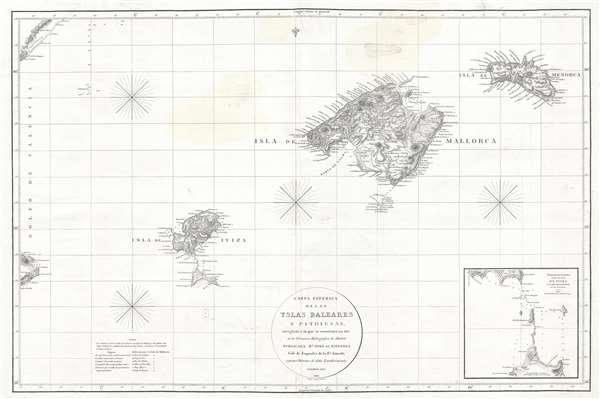

FOR THE ORIGINAL ANTIQUE MAP, WITH HISTORICAL ANALYSIS, CLICK HERE.
Digital Map Information
Geographicus maintains an archive of high-resolution rare map scans. We scan our maps at 300 DPI or higher, with newer images being 600 DPI, (either TIFF or JPEG, depending on when the scan was done) which is most cases in suitable for enlargement and printing.
Delivery
Once you purchase our digital scan service, you will receive a download link via email - usually within seconds. Digital orders are delivered as ZIP files, an industry standard file compression protocol that any computer should be able to unpack. Some of our files are very large, and can take some time to download. Most files are saved into your computer's 'Downloads' folder. All delivery is electronic. No physical product is shipped.
Credit and Scope of Use
You can use your digial image any way you want! Our digital images are unrestricted by copyright and can be used, modified, and published freely. The textual description that accompanies the original antique map is not included in the sale of digital images and remains protected by copyright. That said, we put significant care and effort into scanning and editing these maps, and we’d appreciate a credit when possible. Should you wish to credit us, please use the following credit line:
Courtesy of Geographicus Rare Antique Maps (http://www.geographicus.com).
How Large Can I Print?
In general, at 300 DPI, you should at least be able to double the size of the actual image, more so with our 600 DPI images. So, if the original was 10 x 12 inches, you can print at 20 x 24 inches, without quality loss. If your display requirements can accommodate some loss in image quality, you can make it even larger. That being said, no quality of scan will allow you to blow up at 10 x 12 inch map to wall size without significant quality loss. For more information, it is best consult a printer or reprographics specialist.
Refunds
If the high resolution image you ordered is unavailable, we will fully refund your purchase. Otherwise, digital images scans are a service, not a tangible product, and cannot be returned or refunded once the download link is used.
The Direccion Hidrografía (1787 - 1927), also known as the Deposito Hydrografico and the Direction de Hidrografía, was the Spanish equivalent of the British Admiralty or the U.S. Coast Survey. This organization, founded in 1787, was commissioned to collect and produce accurate nautical charts of all waters frequented by Spanish vessels. In essence, it replaced the Casa de la Contratación de las Indias (House of Trade of the Indies), which closed its doors in 1790. Like most such organizations, the Direccion Hidrografía marked a new age in cartography. Rather than simply collect charts created by navigators, explorers, and merchants, the Direccion Hidrografía worked closely with naval and military personnel to mount cartographic and hydrographic expeditions in pursuit of the most accurate hydrographical, astronomical, and geodetic measurements. The Direccion Hidrografía created a massive library of nautical charts that, though not nearly as common as similar nautical charts by the U.S. Coast Survey and British Admiralty, are highly desirable for the beauty of their manufacture as well as their accuracy and detail. The office was originally located on Calle Ballesta, but relocated to 36 Alcala, both in Madrid. After 1908 the Dirección was subsumed into other governmental agencies. In 1927 the Direccion was absorbed into the Institute and Observatory of San Fernando, located in Cadiz. The library of original maps, charts, and journals was transferred to the Naval Museum of Madrid - where it resides to this day. More by this mapmaker...
José Espinosa y Tello (March 25, 1763 - September 8, 1815) was a Spanish nobleman, naval officer, cartographer, hydrographer, and astronomer. Espinosa y Tello was born in Seville, Spain, the son of Miguel Espinosa, Count del Águila, and Isabel María Tello of Portugal. He studied astronomy at the Observatory of Cadiz and hydrography under the great Spanish chartmaker Vicente Tofiño (1732 - 1795) mapping the coasts of Spain. In 1790 he was in Acapulco, Mexico, where he met and joined the Alejandro Malaspina (1754-1809) 1789 to 1794 scientific expedition around the world. After the expedition he served as Assistant of José de Mazarredo of the Dirección General de la Armada and from 1797 headed the Dirección de Hidrografía. Following the Napoleonic Wars he was dispatched to London to manage the compilation and printing of new Spanish nautical charts. On his return to Madrid he was put in charge of the Depósito Hidrográfico. He died there in 1815. Learn More...
Edward Jones (fl. c. 1799 - 1818) was an English engraver active in London during the early part of the 19th century. Jones was born in London, the son of carpenter. He apprenticed first under the engraver Thomas Orphin and later, after Orphin's death, under William Palmer. In 1799, Jones partnered with Benjamin Smith, publishing as alternatively 'Jones and Smith' or 'Smith and Jones.' Around 1801 a third partner, Joseph Bye, was added, and the imprint changed to 'Jones, Smith and Bye' or 'Jones Smith and Company.' The firm dissolved in 1804 when Smith and Bye were captured by French privateers and imprisoned for 4 years while on business trip to Portugal. Jones lived in Newington (London) where he was neighbor of the important engraver and publisher John Rapkin. Learn More...
Copyright © 2025 Geographicus Rare Antique Maps | Geographicus Rare Antique Maps
This copy is copyright protected.
Copyright © 2025 Geographicus Rare Antique Maps