Digital Image: 1935 Yardley Pictorial Map of Baltimore County, Maryland
BaltimoreCounty-yardley-1935_d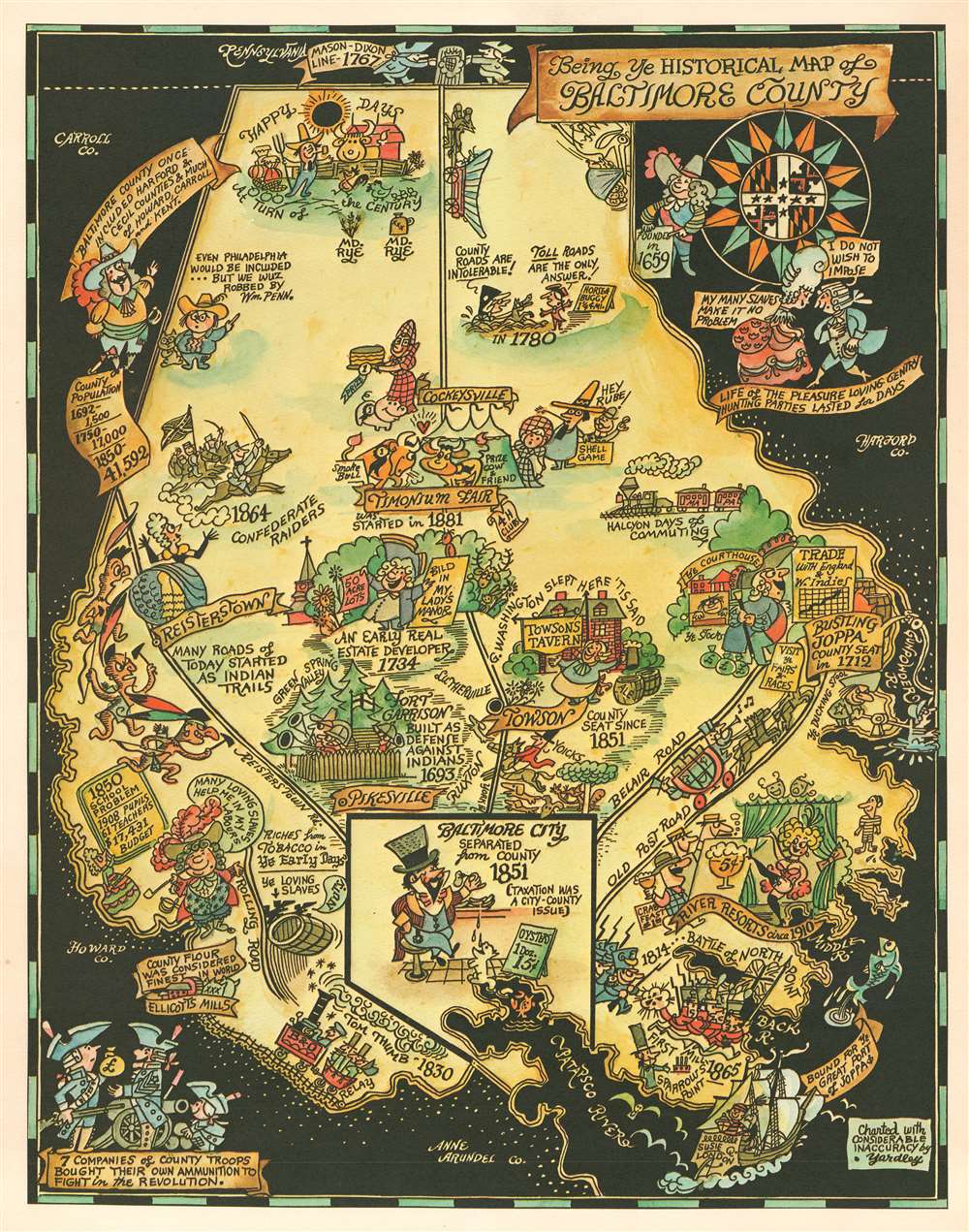

Title
Being Ye Historical Map of Baltimore County.
1935 (undated) 19.25 x 15.25 in (48.895 x 38.735 cm)
1935 (undated) 19.25 x 15.25 in (48.895 x 38.735 cm)
Description
FOR THE ORIGINAL ANTIQUE MAP, WITH HISTORICAL ANALYSIS, CLICK HERE.
Digital Map Information
Geographicus maintains an archive of high-resolution rare map scans. We scan our maps at 300 DPI or higher, with newer images being 600 DPI, (either TIFF or JPEG, depending on when the scan was done) which is most cases in suitable for enlargement and printing.
Delivery
Once you purchase our digital scan service, you will receive a download link via email - usually within seconds. Digital orders are delivered as ZIP files, an industry standard file compression protocol that any computer should be able to unpack. Some of our files are very large, and can take some time to download. Most files are saved into your computer's 'Downloads' folder. All delivery is electronic. No physical product is shipped.
Credit and Scope of Use
You can use your digial image any way you want! Our digital images are unrestricted by copyright and can be used, modified, and published freely. The textual description that accompanies the original antique map is not included in the sale of digital images and remains protected by copyright. That said, we put significant care and effort into scanning and editing these maps, and we’d appreciate a credit when possible. Should you wish to credit us, please use the following credit line:
Courtesy of Geographicus Rare Antique Maps (https://www.geographicus.com).
How Large Can I Print?
In general, at 300 DPI, you should at least be able to double the size of the actual image, more so with our 600 DPI images. So, if the original was 10 x 12 inches, you can print at 20 x 24 inches, without quality loss. If your display requirements can accommodate some loss in image quality, you can make it even larger. That being said, no quality of scan will allow you to blow up at 10 x 12 inch map to wall size without significant quality loss. For more information, it is best consult a printer or reprographics specialist.
Refunds
If the high resolution image you ordered is unavailable, we will fully refund your purchase. Otherwise, digital images scans are a service, not a tangible product, and cannot be returned or refunded once the download link is used.
Cartographer
Richard Quincy Yardley (March 11, 1903 - November 24, 1979), known euphemistically as 'Moco,' was an American cartoonist based in Baltimore. Yardley worked as a cartoonist for the Baltimore Sun from 1923. In 1949 he became the editorial cartoonist for the Baltimore Sun, a position he held for roughly 20 years. He also produced cartoons for The Saturday Evening Post, The New Yorker and the Reporter. His syndicated daily comic, Our Ancestors, was published from 1961 to 1965. His work exhibited a humorous satirical style drawing on local personalities and historical events. One writer, Charles Bissell, described his work thus,
His style, which might be described as early Ming, middle comic strip, late Picasso, and all Yardley—or perhaps better some other way-is not suitable for editorial cartoons. To begin with, it's not serious. We all know how you've got to be mighty serious about lots of things-atom bombs, for instance. You couldn't put over something big and profound by drawing a couple of nudeniks with four heads, a little banjo-eyed character in a beret and maybe a cat, all caught up in some sort of symbolical astral soup and expect to scare daylights out of your readers. Well, no, you couldn't—but Yardley can. (AAEC News, April 1964)He issued several satirical cartoon maps, including a map of Herr Hitler's Heaven, Johns Hopkins Hospital, Anne Arundel County, Baltimore County, and Annapolis. Yardley was a member of the National Cartoonists Society, the American Association of Editorial Cartoonists and the National Press Club. He retired in 1972. More by this mapmaker...
References
Rumsey 11708.002.