Digital Image: 1787 Ramsay Map or Plan of Yorktown, Virginia (Revolutionary War)
BattleofYorktown-ramsay-1787_d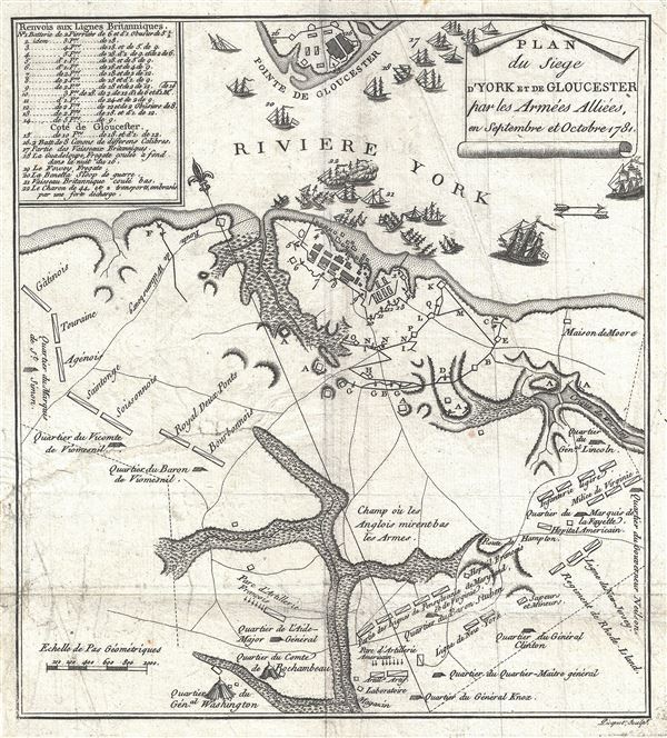

Title
Plan du Siege d'York et de Gloucester par les Armees Alliees en Septembre et Octobre 1781.
1787 (undated) 9 x 8 in (22.86 x 20.32 cm) 1 : 9600
1787 (undated) 9 x 8 in (22.86 x 20.32 cm) 1 : 9600
Description
FOR THE ORIGINAL ANTIQUE MAP, WITH HISTORICAL ANALYSIS, CLICK HERE.
Digital Map Information
Geographicus maintains an archive of high-resolution rare map scans. We scan our maps at 300 DPI or higher, with newer images being 600 DPI, (either TIFF or JPEG, depending on when the scan was done) which is most cases in suitable for enlargement and printing.
Delivery
Once you purchase our digital scan service, you will receive a download link via email - usually within seconds. Digital orders are delivered as ZIP files, an industry standard file compression protocol that any computer should be able to unpack. Some of our files are very large, and can take some time to download. Most files are saved into your computer's 'Downloads' folder. All delivery is electronic. No physical product is shipped.
Credit and Scope of Use
You can use your digial image any way you want! Our digital images are unrestricted by copyright and can be used, modified, and published freely. The textual description that accompanies the original antique map is not included in the sale of digital images and remains protected by copyright. That said, we put significant care and effort into scanning and editing these maps, and we’d appreciate a credit when possible. Should you wish to credit us, please use the following credit line:
Courtesy of Geographicus Rare Antique Maps (http://www.geographicus.com).
How Large Can I Print?
In general, at 300 DPI, you should at least be able to double the size of the actual image, more so with our 600 DPI images. So, if the original was 10 x 12 inches, you can print at 20 x 24 inches, without quality loss. If your display requirements can accommodate some loss in image quality, you can make it even larger. That being said, no quality of scan will allow you to blow up at 10 x 12 inch map to wall size without significant quality loss. For more information, it is best consult a printer or reprographics specialist.
Refunds
If the high resolution image you ordered is unavailable, we will fully refund your purchase. Otherwise, digital images scans are a service, not a tangible product, and cannot be returned or refunded once the download link is used.
Cartographer S
David Ramsay (April 2, 1749 - May 8, 1815) was an American physician, public official, and historian from Charleston, South Carolina and is recognized as one of the first major historians of the American Revolution. Born In Lancaster County, Pennsylvania, Ramsay graduated from Princeton in 1765 and received a medical degree from the University of Pennsylvania in 1773. He settled in Charleston where he opened a medical practice. Ramsay served as a member of the South Carolina legislature from 1776 until 1783 and joined the South Carolina militia in 1780 as a field surgeon when the British threatened Charleston. After the fall of Charleston, Ramsay was imprisoned for nearly a year until he was exchanged. He then served as a member of the Continental Congress from 1782 until 1786, and served as its chairman from November 23, 1785 until May 12, 1786 due to the absence of John Hancock. In 1785 Ramsay published History of the Revolution in South Carolina in two volumes, which has the distinction of being the first book to receive a copyright in the United States. Ramsay also published a two-volume History of the American Revolution in 1789, Life of Washington in 1807, and a two volume History of South Carolina in 1809. More by this mapmaker...
Charles Picquet (April 15, 1771 – January 15, 1827) was a French cartographer active in Paris during the Napoleonic and post-Napoleonic Eras. Picquet was born in Romagna-sous-Montfaucon, Meuse, France. From about 1798 Picquet supplied maps to the Dépôt de la Guerre. From 1806 he was appointed to Napoleon's Cabinet Topographique. Being politically dexterous, he was able to retain this position after the fall of Napoleon under both Louis XVIII and Charles X. Under Louis XVIII he also obtained the Brevet de Géographe Ordinaire du Cabinet Topographique. He worked with the cartographer Adrien-Hubert Brué on a major atlas project. When Charles Picquet died in 1827, his son, Pierre-Jacques Picquet, continued to publish under his father's imprint name well into the middle part of the 19th century. Learn More...
Source
Ramsay, D., Histoire de la Revolution d'Amerique, (Paris) 1787.