This copy is copyright protected.
Copyright © 2025 Geographicus Rare Antique Maps
Digital Image: 1880 Stanford Map of Bermuda Recording a 1921 Visit in Manuscript
Bermuda-stanford-1880_d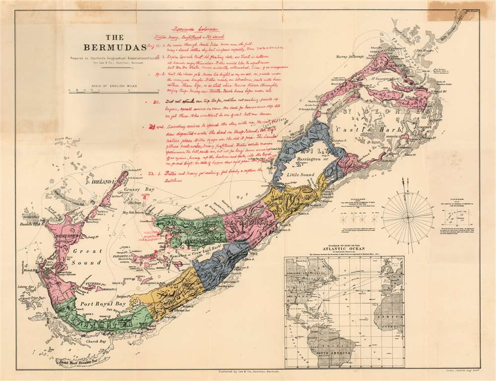

FOR THE ORIGINAL ANTIQUE MAP, WITH HISTORICAL ANALYSIS, CLICK HERE.
Digital Map Information
Geographicus maintains an archive of high-resolution rare map scans. We scan our maps at 300 DPI or higher, with newer images being 600 DPI, (either TIFF or JPEG, depending on when the scan was done) which is most cases in suitable for enlargement and printing.
Delivery
Once you purchase our digital scan service, you will receive a download link via email - usually within seconds. Digital orders are delivered as ZIP files, an industry standard file compression protocol that any computer should be able to unpack. Some of our files are very large, and can take some time to download. Most files are saved into your computer's 'Downloads' folder. All delivery is electronic. No physical product is shipped.
Credit and Scope of Use
You can use your digial image any way you want! Our digital images are unrestricted by copyright and can be used, modified, and published freely. The textual description that accompanies the original antique map is not included in the sale of digital images and remains protected by copyright. That said, we put significant care and effort into scanning and editing these maps, and we’d appreciate a credit when possible. Should you wish to credit us, please use the following credit line:
Courtesy of Geographicus Rare Antique Maps (http://www.geographicus.com).
How Large Can I Print?
In general, at 300 DPI, you should at least be able to double the size of the actual image, more so with our 600 DPI images. So, if the original was 10 x 12 inches, you can print at 20 x 24 inches, without quality loss. If your display requirements can accommodate some loss in image quality, you can make it even larger. That being said, no quality of scan will allow you to blow up at 10 x 12 inch map to wall size without significant quality loss. For more information, it is best consult a printer or reprographics specialist.
Refunds
If the high resolution image you ordered is unavailable, we will fully refund your purchase. Otherwise, digital images scans are a service, not a tangible product, and cannot be returned or refunded once the download link is used.
Edward Stanford (May 27, 1827 - November 3, 1904) was one of the most prolific map publishing firms of the late 19th century. The company began as a partnership in 1848 between the 21 year old Edward Stanford and the established map dealer Trelawney Saunders. By 1853 the partnership had dissolved and Edward Stanford took full control of the business. A subsequent series of expansions and exciting new map issues finally led to the production of Stanford's masterwork, "Stanford's Library Map of London". This map is still available and remains somewhat accurate. At the time of publishing it was hailed by the Royal Geographical Society as "the most perfect map of London that has ever been issued". In 1882 Edward Stanford Sr. passed the firm on to his son, Edward Stanford Jr. who continued in his father's proud tradition. Today the Stanford firm still publishes maps and remains one of the most important and prolific cartographic publishers in the world. More by this mapmaker...
Donald McPhee Lee (February 11, 1804 - February 11, 1883) was a Canadian-born Bermudan publisher and newspaperman, the first editor of Bermuda's The Royal Gazette, He learned the printing trade in St. John's, Newfoundland. His father, who had served with the British military in Bermuda, learned of a vacancy for King's Printer there and submitted his son's name for consideration. In addition to the printing of official government documents, his duties included the publishing and editing of Bermuda's government newspaper, the Royal Gazette. He held this position for fifty five years, until his death. Lee also ran a stationery story and published an annual almanac. His second eldest son Gregory Vose Lee (May 5 1841 - February 28, 1898) took over as editor and remained in the position until his death in 1898, when the newspaper’s connection with the Lee family ended. His tenure almost did not evern begin: on his way to Bermuda from Halifax in 1827, he ran into stormy waters three days into the journey and was lost at sea for 11 weeks. Given up for dead, his brother David Ross Lee put out the first two editions of the newspaper before he finally arrived in St. George’s in January 1828, his family was overjoyed by his miraculous survival. Lee's tale - which would not be published until after his death - told of a captain who went blind, a navigator who was illiterate, and two crewmen who were washed overboard by a wave and back onto the boat. Learn More...
Copyright © 2025 Geographicus Rare Antique Maps | Geographicus Rare Antique Maps
This copy is copyright protected.
Copyright © 2025 Geographicus Rare Antique Maps