This copy is copyright protected.
Copyright © 2025 Geographicus Rare Antique Maps
Digital Image: 1715 Samuel Thornton Chart of Guzarat (Gujarat) and Bombay (Mumbai)
BombayGuzarat-thornton-1716_d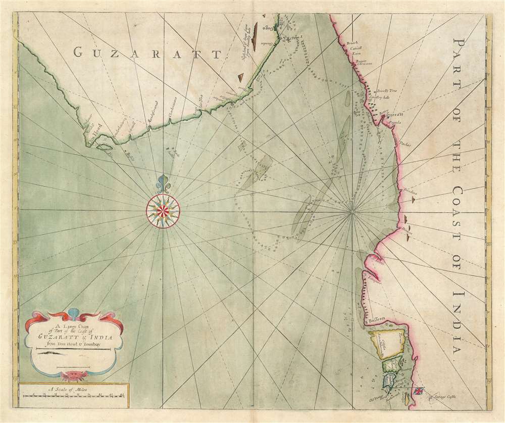

FOR THE ORIGINAL ANTIQUE MAP, WITH HISTORICAL ANALYSIS, CLICK HERE.
Digital Map Information
Geographicus maintains an archive of high-resolution rare map scans. We scan our maps at 300 DPI or higher, with newer images being 600 DPI, (either TIFF or JPEG, depending on when the scan was done) which is most cases in suitable for enlargement and printing.
Delivery
Once you purchase our digital scan service, you will receive a download link via email - usually within seconds. Digital orders are delivered as ZIP files, an industry standard file compression protocol that any computer should be able to unpack. Some of our files are very large, and can take some time to download. Most files are saved into your computer's 'Downloads' folder. All delivery is electronic. No physical product is shipped.
Credit and Scope of Use
You can use your digial image any way you want! Our digital images are unrestricted by copyright and can be used, modified, and published freely. The textual description that accompanies the original antique map is not included in the sale of digital images and remains protected by copyright. That said, we put significant care and effort into scanning and editing these maps, and we’d appreciate a credit when possible. Should you wish to credit us, please use the following credit line:
Courtesy of Geographicus Rare Antique Maps (http://www.geographicus.com).
How Large Can I Print?
In general, at 300 DPI, you should at least be able to double the size of the actual image, more so with our 600 DPI images. So, if the original was 10 x 12 inches, you can print at 20 x 24 inches, without quality loss. If your display requirements can accommodate some loss in image quality, you can make it even larger. That being said, no quality of scan will allow you to blow up at 10 x 12 inch map to wall size without significant quality loss. For more information, it is best consult a printer or reprographics specialist.
Refunds
If the high resolution image you ordered is unavailable, we will fully refund your purchase. Otherwise, digital images scans are a service, not a tangible product, and cannot be returned or refunded once the download link is used.
Samuel Thornton (1665 - October, 1715) was an English map publisher active in the late 17th and early 18th centuries. Samuel was the son of John Thornton (1641 - 1708), the second major publisher of the English Pilot. Samuel inherited his father's business and the English Pilot plates in 1708, publishing revised edition of the English Pilot, The Third Book in 1711, and The English Pilot, the Fourth Book. Describing the West-Indian Navigation in 1713. Like his father, Thornton enjoyed a mandate from the British East Indian Company and was their primary chart provider. His name is attached to several charts of the India coast that he added to the English Pilot, The Third Book, 1703. When he died, publication of the English Pilot was taken over by Richard Mount and Thomas Page. They, unlike their predecessors, were not mandated by the British East India Company. More by this mapmaker...
Mount and Page (fl. 1701 - 1760) was a London based firm of religious and maritime publishers that flourished in the 18th century. With the publication of the 1732 English Pilot, the Mount and Page name became well-known worldwide as an imprint of nautical charts. The firm was founded at Tower Hill, London, in 1701 by Richard Mount (1654 - 1722) and his apprentice Thomas Page (1780 - March 15, 1733). Mount had previously been in partnership with his father-in-law William Fisher (1631 - 1691) and inherited the business on the latter's death. Page completed his apprenticeship in 1716. Now fully partnered, Mount and Page subsequently acquired the map plates several defunct British nautical chart publishers, including Greenville Collins, Jeremiah Seller, Charles Price, and John and Samuel Thornton - thus nearly monopolizing the British nautical chart business. The firm consequently received several lucrative government contracts and thereby flourished throughout the 18th century, making the fortunes of both families. Successive generations of Mounts and Pages worked in the business, and the families intermarried. Its staple titles were The English Pilot and Navigatio Britannica by John Barrow. By the 1760s, Richard Mount's grandson John Mount (1725 - 1786) was able to retire to Berkshire where he built the stately mansion, Wasing Place. John's son William (1753 - 1815) was the last to work in the map business, and later generations went into politics. Learn More...
Copyright © 2025 Geographicus Rare Antique Maps | Geographicus Rare Antique Maps
This copy is copyright protected.
Copyright © 2025 Geographicus Rare Antique Maps