This copy is copyright protected.
Copyright © 2025 Geographicus Rare Antique Maps
Digital Image: 1945 Anderson and Clement Railroad Map of the Northeastern United States
BostonMaineCentral-clement-1945_d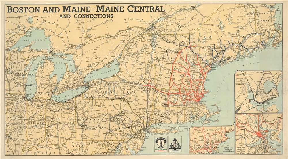


FOR THE ORIGINAL ANTIQUE MAP, WITH HISTORICAL ANALYSIS, CLICK HERE.
Digital Map Information
Geographicus maintains an archive of high-resolution rare map scans. We scan our maps at 300 DPI or higher, with newer images being 600 DPI, (either TIFF or JPEG, depending on when the scan was done) which is most cases in suitable for enlargement and printing.
Delivery
Once you purchase our digital scan service, you will receive a download link via email - usually within seconds. Digital orders are delivered as ZIP files, an industry standard file compression protocol that any computer should be able to unpack. Some of our files are very large, and can take some time to download. Most files are saved into your computer's 'Downloads' folder. All delivery is electronic. No physical product is shipped.
Credit and Scope of Use
You can use your digial image any way you want! Our digital images are unrestricted by copyright and can be used, modified, and published freely. The textual description that accompanies the original antique map is not included in the sale of digital images and remains protected by copyright. That said, we put significant care and effort into scanning and editing these maps, and we’d appreciate a credit when possible. Should you wish to credit us, please use the following credit line:
Courtesy of Geographicus Rare Antique Maps (http://www.geographicus.com).
How Large Can I Print?
In general, at 300 DPI, you should at least be able to double the size of the actual image, more so with our 600 DPI images. So, if the original was 10 x 12 inches, you can print at 20 x 24 inches, without quality loss. If your display requirements can accommodate some loss in image quality, you can make it even larger. That being said, no quality of scan will allow you to blow up at 10 x 12 inch map to wall size without significant quality loss. For more information, it is best consult a printer or reprographics specialist.
Refunds
If the high resolution image you ordered is unavailable, we will fully refund your purchase. Otherwise, digital images scans are a service, not a tangible product, and cannot be returned or refunded once the download link is used.
The J. W. Clement Company (1908 - 19xx) was an American printing and publishing firm based in Buffalo, New York. Founded in 1908 by Helen C. Springer, David L. Johnston, and Gustave Hornung, the firm eventually grew to become one of the largest printing and publishing firms in the eastern U.S. It stopped publishing maps in 1963 when the superintendent of the map department retired. At some point, the J. W. Clement Company became associated with the Matthews-Northrup Company, another Buffalo-based publishing firm, but we have been unable to determine any details about that event. More by this mapmaker...
Crawford Covington Anderson (March 2, 1898 - December 24, 1980) was an American map maker. Born in Kentucky, he was attending the University of Kentucky before being drafted into the U.S. Army in 1918. By the 1940s, Anderson was living in Buffalo and working as a map maker for the J. W. Clement Company. From his World War II draft card, we know that he was married to Irene Anderson in February 1942, but do not know how long they had been married. He died in California. Learn More...
Copyright © 2025 Geographicus Rare Antique Maps | Geographicus Rare Antique Maps
This copy is copyright protected.
Copyright © 2025 Geographicus Rare Antique Maps