This copy is copyright protected.
Copyright © 2025 Geographicus Rare Antique Maps
Digital Image: 1928 Canadian Pacific Pictorial Map of the Canadian Rocky Mountains
CanadianRockies-canadianpacific-1928_d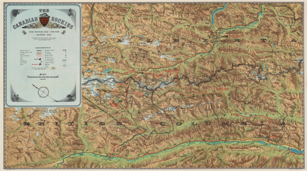


FOR THE ORIGINAL ANTIQUE MAP, WITH HISTORICAL ANALYSIS, CLICK HERE.
Digital Map Information
Geographicus maintains an archive of high-resolution rare map scans. We scan our maps at 300 DPI or higher, with newer images being 600 DPI, (either TIFF or JPEG, depending on when the scan was done) which is most cases in suitable for enlargement and printing.
Delivery
Once you purchase our digital scan service, you will receive a download link via email - usually within seconds. Digital orders are delivered as ZIP files, an industry standard file compression protocol that any computer should be able to unpack. Some of our files are very large, and can take some time to download. Most files are saved into your computer's 'Downloads' folder. All delivery is electronic. No physical product is shipped.
Credit and Scope of Use
You can use your digial image any way you want! Our digital images are unrestricted by copyright and can be used, modified, and published freely. The textual description that accompanies the original antique map is not included in the sale of digital images and remains protected by copyright. That said, we put significant care and effort into scanning and editing these maps, and we’d appreciate a credit when possible. Should you wish to credit us, please use the following credit line:
Courtesy of Geographicus Rare Antique Maps (http://www.geographicus.com).
How Large Can I Print?
In general, at 300 DPI, you should at least be able to double the size of the actual image, more so with our 600 DPI images. So, if the original was 10 x 12 inches, you can print at 20 x 24 inches, without quality loss. If your display requirements can accommodate some loss in image quality, you can make it even larger. That being said, no quality of scan will allow you to blow up at 10 x 12 inch map to wall size without significant quality loss. For more information, it is best consult a printer or reprographics specialist.
Refunds
If the high resolution image you ordered is unavailable, we will fully refund your purchase. Otherwise, digital images scans are a service, not a tangible product, and cannot be returned or refunded once the download link is used.
Arthur Oliver Wheeler (May 1, 1860 - March 20, 1945) was an Irish Canadian surveyor and mountaineer. Born in Lyrath, Ireland, Wheeler attended schools Ballinasloe College in County Galway, Ireland, and Dulwich College in London before moving to Canada in 1876. For the next nine years he worked in midwestern Canada as a surveyor, when, in 1885, he was appointed to the Surveys branch of the Department of the Interior under Dr. Deville. Deville, the originator of Canadian photo-topographical methods, taught Wheeler these methods and how to be a mountain topographer while mapping parts of the Canadian Rocky Mountains. Wheeler then elected to start his own surveying firm in 1890, but by 1893 he had returned to the Department of the Interior. Then, starting in 1895, he began working on surveying projects that lasted almost continuously until 1925 and the completion of the Alb3erta-British Columbia provincial boundary survey. During these thirty years, Wheeler worked on projects for the Canadian Pacific Railway, and he took part in surveying the International Boundary between Alaska and the Yukon Territory, then being arbitrated in London. He returned to private practice in 1910, but remained out of government service only until 1913, when he was named Commissioner for British Columbia on the Interprovincial Boundary Survey, mapping and surveying over 600 miles of the main range Rocky Mountains along the Continental Divide. Wheeler helped found the Alpine Clube of Canada (ACC) and the Canadian Alpine Journal. Wheeler served as President of the ACC from 1906 through 1910, and as Managing Director from 1907 until 1930. Wheeler served as Editor of the Journal until 1926. He was Honorary President of the ACC from 1926 until his death. He married Clara Macoun in 1887, who passed away in 1923. He married Emmeline Savatard in 1924. He had one son. More by this mapmaker...
Copyright © 2025 Geographicus Rare Antique Maps | Geographicus Rare Antique Maps
This copy is copyright protected.
Copyright © 2025 Geographicus Rare Antique Maps