This copy is copyright protected.
Copyright © 2025 Geographicus Rare Antique Maps
Digital Image: 1651 Boschini Map of Crete or Candia
Candia-boschini-1651_d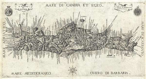

FOR THE ORIGINAL ANTIQUE MAP, WITH HISTORICAL ANALYSIS, CLICK HERE.
Digital Map Information
Geographicus maintains an archive of high-resolution rare map scans. We scan our maps at 300 DPI or higher, with newer images being 600 DPI, (either TIFF or JPEG, depending on when the scan was done) which is most cases in suitable for enlargement and printing.
Delivery
Once you purchase our digital scan service, you will receive a download link via email - usually within seconds. Digital orders are delivered as ZIP files, an industry standard file compression protocol that any computer should be able to unpack. Some of our files are very large, and can take some time to download. Most files are saved into your computer's 'Downloads' folder. All delivery is electronic. No physical product is shipped.
Credit and Scope of Use
You can use your digial image any way you want! Our digital images are unrestricted by copyright and can be used, modified, and published freely. The textual description that accompanies the original antique map is not included in the sale of digital images and remains protected by copyright. That said, we put significant care and effort into scanning and editing these maps, and we’d appreciate a credit when possible. Should you wish to credit us, please use the following credit line:
Courtesy of Geographicus Rare Antique Maps (http://www.geographicus.com).
How Large Can I Print?
In general, at 300 DPI, you should at least be able to double the size of the actual image, more so with our 600 DPI images. So, if the original was 10 x 12 inches, you can print at 20 x 24 inches, without quality loss. If your display requirements can accommodate some loss in image quality, you can make it even larger. That being said, no quality of scan will allow you to blow up at 10 x 12 inch map to wall size without significant quality loss. For more information, it is best consult a printer or reprographics specialist.
Refunds
If the high resolution image you ordered is unavailable, we will fully refund your purchase. Otherwise, digital images scans are a service, not a tangible product, and cannot be returned or refunded once the download link is used.
Marco Boschini (1602 - 1681) was an Italian baroque period painter, engraver, art dealer, and writer active in Venice. Boschini was born in Venice and educated at Palma il Giovane. While Boschini's paintings are today well known, at the time he was primarily an art dealer whose clients included Cardinal Leopoldo de'Medici. In cartographic circles, he is best known for his work on Crete, including a book at least 3 significant maps, all of which were derived from the manuscript maps of Francesco Basilicata. More by this mapmaker...
Francesco Basilicata (???? – c. 1640) was a 17th century Italian cartographer and military engineer. Basilicata worked in the service of the Republic of Venice and is known for his maps and drawings of the island of Crete. Little is known of his early life, but it has been suggested that he may have been from Palermo. He lived in Crete during the first two decades of 17th century, in the last days of Venetian hegemony over the island. Basilicata fell in love with the island's rugged scenery and spent the years between 1612 and 1629 meticulously mapping the entire island. His maps of Crete from the foundation for must subsequent maps until the early 18th century. Learn More...
Copyright © 2025 Geographicus Rare Antique Maps | Geographicus Rare Antique Maps
This copy is copyright protected.
Copyright © 2025 Geographicus Rare Antique Maps