This copy is copyright protected.
Copyright © 2025 Geographicus Rare Antique Maps
Digital Image: 1839 Glynn Wall-Map Nautical Chart of the Cape Fear River
CapeFearRiver-glynn-1839_d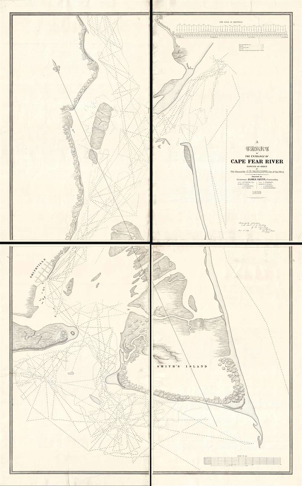

FOR THE ORIGINAL ANTIQUE MAP, WITH HISTORICAL ANALYSIS, CLICK HERE.
Digital Map Information
Geographicus maintains an archive of high-resolution rare map scans. We scan our maps at 300 DPI or higher, with newer images being 600 DPI, (either TIFF or JPEG, depending on when the scan was done) which is most cases in suitable for enlargement and printing.
Delivery
Once you purchase our digital scan service, you will receive a download link via email - usually within seconds. Digital orders are delivered as ZIP files, an industry standard file compression protocol that any computer should be able to unpack. Some of our files are very large, and can take some time to download. Most files are saved into your computer's 'Downloads' folder. All delivery is electronic. No physical product is shipped.
Credit and Scope of Use
You can use your digial image any way you want! Our digital images are unrestricted by copyright and can be used, modified, and published freely. The textual description that accompanies the original antique map is not included in the sale of digital images and remains protected by copyright. That said, we put significant care and effort into scanning and editing these maps, and we’d appreciate a credit when possible. Should you wish to credit us, please use the following credit line:
Courtesy of Geographicus Rare Antique Maps (http://www.geographicus.com).
How Large Can I Print?
In general, at 300 DPI, you should at least be able to double the size of the actual image, more so with our 600 DPI images. So, if the original was 10 x 12 inches, you can print at 20 x 24 inches, without quality loss. If your display requirements can accommodate some loss in image quality, you can make it even larger. That being said, no quality of scan will allow you to blow up at 10 x 12 inch map to wall size without significant quality loss. For more information, it is best consult a printer or reprographics specialist.
Refunds
If the high resolution image you ordered is unavailable, we will fully refund your purchase. Otherwise, digital images scans are a service, not a tangible product, and cannot be returned or refunded once the download link is used.
James Glynn (June 28, 1801 - March 13, 1871) was an American naval officer active in the United States during the middle part of the 19th century. Glynn joined the U.S. Navy on March 4, 1815, when he was just 14 years old. He became a lieutenant in 1825, a commander in 1841, and a captain in 1855. As a lieutenant he commanded 2 ships, the schooners U.S.S. Experiment and U.S.S. Engineer, which were charged to conduct a detailed survey of the Cape Fear River area for the potential construction of a Southern Navy Yard. During the Mexican-American War Glynn served on the coast of California. After the war, he was sent to China in command of the U.S.S. Preble, where learning of 15 American whalers imprisoned after a shipwreck in Hokkaido, he turned his attentions to Japan. Through a show of force and keen diplomacy he negotiated with the isolationist Tokugawa officials an secured the release of the surviving prisoners. His work is credited with setting the stage for the expedition of Commodore Matthew Perry to Japan in 1853 and 1854. More by this mapmaker...
Matthew Fontaine Maury (January 14, 1806 - February 1, 1873) was an American astronomer, historian, oceanographer, meteorologist, cartographer, author, geologist, educator, and United States Navy officer. Maury was born in Spotsylvania County, Virginia, near Fredericksburg. He was nicknamed "Pathfinder of the Seas" and "Father of Modern Oceanography and Naval Meteorology" and later, "Scientist of the Seas," due to the publication of his extensive works in his books, especially Physical Geography of the Sea (1855), the first extensive and comprehensive book on oceanography to be published. Maury made many important new contributions to charting winds and ocean currents, including ocean lanes for passing ships at sea. In 1825 at age nineteen, Maury joined the United States Navy as a midshipman on board the frigate USS Brandywine. Almost immediately he began to study the seas and record methods of navigation. When a leg injury left him unfit for sea duty, Maury devoted his time to the study of navigation, meteorology, winds, and currents. His hard work on and love of plotting the oceans paid off when he became Superintendent of the U.S. Naval Observatory and head of the Depot of Charts and Instruments. There, Maury studied thousands of ships' logs and charts. He published the Wind and Current Chart of the North Atlantic, which showed sailors how to use the ocean's currents and winds to their advantage and drastically reduced the length of ocean voyages. Maury's uniform system of recording oceanographic data was adopted by navies and merchant marines around the world and was used to develop charts for all the major trade routes. Maury's work on ocean currents led him to advocate his theory of the Northwest Passage, as well as the hypothesis that an area in the ocean near the North Pole is occasionally free of ice. The reasoning behind this was sound: Marked harpoons found in captured whales in the Atlantic had been shot by ships in the Pacific and vice versa, and this occurred with a frequency that would have been impossible had the whales traveled around Cape Horn. With the outbreak of the Civil War, Maury, a Virginian, resigned his commission as a U.S. Navy commander and joined the Confederacy. He spent the war in the South, as well as abroad in Great Britain, acquiring ships for the Confederacy. As a result of his Confederate sympathies, Maury's work was de-emphasized in the Reconstruction era, particularly by Alexander D. Bache, head of the U.S. Coast Survey. Following the war, Maury accepted a teaching position at the Virginia Military Institute in Lexington, Virginia. He died at his home in Lexington in 1873 after completing an exhausting national lecture tour. Learn More...
Philip Haas (1808 - c. 186?) was a German-American daguerreotypist and lithographer active in the mid-19th century. Haas was born in Germany but emigrated to the United States in 1834, rapidly establishing himself as a lithographer and printer in Washington D. C. Between 1834 and 1840 he received several government printing contracts from the U.S. Navy and other offices. Around 1840 he may have traveled to Paris to study the newly invented daguerreotype photo system. His earliest known daguerreotype is dated March of 1843. With his 1843 portrait of president John Quincy Adams, Haas is credited with being the first to transfer a daguerreotype directly to lithographic stone. He relocated to New York City in 1944, opening a daguerreotype gallery on Broadway, which he ran to about 1860. In 1860, at the outbreak of the American Civil War, Haas enlisted with First New York Engineers and was sent to South Carolina. He may have lied about his age, as he was 53 at the time, too old for enlisted service. Taking advantage of his daguerreotyping skills, Haas, produced several important photographs, including images of the U.S.S. New Ironsides in action. Poor health and an end to the war led him to retired on May 25, 1863. The date of his death is unknown. Learn More...
Copyright © 2025 Geographicus Rare Antique Maps | Geographicus Rare Antique Maps
This copy is copyright protected.
Copyright © 2025 Geographicus Rare Antique Maps