This copy is copyright protected.
Copyright © 2025 Geographicus Rare Antique Maps
Digital Image: 1901 Maunsell Map of Kurdistan (Southeastern Turkey)
CentralKurdistan-maunsell-1901_d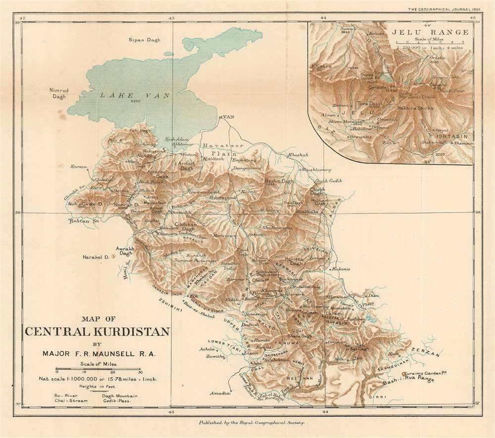

FOR THE ORIGINAL ANTIQUE MAP, WITH HISTORICAL ANALYSIS, CLICK HERE.
Digital Map Information
Geographicus maintains an archive of high-resolution rare map scans. We scan our maps at 300 DPI or higher, with newer images being 600 DPI, (either TIFF or JPEG, depending on when the scan was done) which is most cases in suitable for enlargement and printing.
Delivery
Once you purchase our digital scan service, you will receive a download link via email - usually within seconds. Digital orders are delivered as ZIP files, an industry standard file compression protocol that any computer should be able to unpack. Some of our files are very large, and can take some time to download. Most files are saved into your computer's 'Downloads' folder. All delivery is electronic. No physical product is shipped.
Credit and Scope of Use
You can use your digial image any way you want! Our digital images are unrestricted by copyright and can be used, modified, and published freely. The textual description that accompanies the original antique map is not included in the sale of digital images and remains protected by copyright. That said, we put significant care and effort into scanning and editing these maps, and we’d appreciate a credit when possible. Should you wish to credit us, please use the following credit line:
Courtesy of Geographicus Rare Antique Maps (http://www.geographicus.com).
How Large Can I Print?
In general, at 300 DPI, you should at least be able to double the size of the actual image, more so with our 600 DPI images. So, if the original was 10 x 12 inches, you can print at 20 x 24 inches, without quality loss. If your display requirements can accommodate some loss in image quality, you can make it even larger. That being said, no quality of scan will allow you to blow up at 10 x 12 inch map to wall size without significant quality loss. For more information, it is best consult a printer or reprographics specialist.
Refunds
If the high resolution image you ordered is unavailable, we will fully refund your purchase. Otherwise, digital images scans are a service, not a tangible product, and cannot be returned or refunded once the download link is used.
Francis Richard Maunsell (February 14, 1861 - 1936) was a British diplomat, hobbyist archeologist, mapmaker, army officer, and intelligence operative active in the Middle East in the late 19th and early 20th centuries. Maunsell was born in Limerick and is of Anglo-Irish descent. He studied at Cheltenham College and attended the Royal Military Academy at Woolwich. Upon graduating, he was commissioned as a junior officer in the Royal Artillery. Having shown an academic proficiency at mapmaking, he was assigned to the mapping of Gibraltar and the adjoining lands in 1885. Impressed with his work, he was reassigned to the Ottoman Empire, where the British were eager to develop a more sophisticated reconnoiter. Posing as a political attaché he traveled throughout Mesopotamia, Kurdistan, Persia, and Luristan, collecting and compiling data on the people and country. It was not until 1892, when he was assigned surveying equipment, that he started mapping in earnest. Maunsell remained in eastern Turkey until 1905, at which time he was sent as a staff officer to Macedonia. From 1907 to 1910, he returned to London, where her served as Director of Military Intelligence. When World War I broke out in 1914, he was an advisor to MI2, the department of Military Intelligence charged with geographical intelligence on the Ottoman Empire. Maunsell's contributions as a cartographer were significant, but most were lost or destroyed in a 1930s cleansing of military documents by the British Intelligence Office. Maunsell appears to have fallen on hard times late in life and died in 1936. There are rumors that he was pushed out of MI after a showdown concerning undefined sexual impropriety in Turkey. More by this mapmaker...
Royal Geographical Society (fl. 1830 - present) is a British Society established in 1830 to promote geographical science and exploration. Originally titled the "Geographical Society of London", the RGS received its royal charter from Queen Victoria in 1859 shortly after absorbing several similar but more regional societies including the African Association, the Raleigh Club and the Palestine Association. The RGS sponsored many of the most important and exciting voyages of exploration ever undertaken, including the exploration of Charles Darwin, David Livingstone, Robert Falcon Scott, Richard F. Burton, John Speke, George Hayward, H. M Stanley, Ernest Shackleton and Sir Edmond Hillary. Today, the RGS remains a leading global sponsor of geographical and scientific studies. The Society is based in Lowther Lodge, South Kensington, London. Learn More...
Copyright © 2025 Geographicus Rare Antique Maps | Geographicus Rare Antique Maps
This copy is copyright protected.
Copyright © 2025 Geographicus Rare Antique Maps