This copy is copyright protected.
Copyright © 2025 Geographicus Rare Antique Maps
Digital Image: 1899 Otis Map of Central Luzon, Philippines, during the Philippine-American War
CentralLuzon-otis-1899-2_d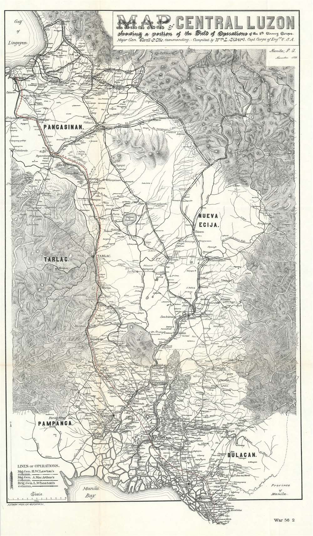

FOR THE ORIGINAL ANTIQUE MAP, WITH HISTORICAL ANALYSIS, CLICK HERE.
Digital Map Information
Geographicus maintains an archive of high-resolution rare map scans. We scan our maps at 300 DPI or higher, with newer images being 600 DPI, (either TIFF or JPEG, depending on when the scan was done) which is most cases in suitable for enlargement and printing.
Delivery
Once you purchase our digital scan service, you will receive a download link via email - usually within seconds. Digital orders are delivered as ZIP files, an industry standard file compression protocol that any computer should be able to unpack. Some of our files are very large, and can take some time to download. Most files are saved into your computer's 'Downloads' folder. All delivery is electronic. No physical product is shipped.
Credit and Scope of Use
You can use your digial image any way you want! Our digital images are unrestricted by copyright and can be used, modified, and published freely. The textual description that accompanies the original antique map is not included in the sale of digital images and remains protected by copyright. That said, we put significant care and effort into scanning and editing these maps, and we’d appreciate a credit when possible. Should you wish to credit us, please use the following credit line:
Courtesy of Geographicus Rare Antique Maps (http://www.geographicus.com).
How Large Can I Print?
In general, at 300 DPI, you should at least be able to double the size of the actual image, more so with our 600 DPI images. So, if the original was 10 x 12 inches, you can print at 20 x 24 inches, without quality loss. If your display requirements can accommodate some loss in image quality, you can make it even larger. That being said, no quality of scan will allow you to blow up at 10 x 12 inch map to wall size without significant quality loss. For more information, it is best consult a printer or reprographics specialist.
Refunds
If the high resolution image you ordered is unavailable, we will fully refund your purchase. Otherwise, digital images scans are a service, not a tangible product, and cannot be returned or refunded once the download link is used.
Andrew B. Graham (1845 - September 9, 1909) was an American lithographer active in Washington, D.C. in late 19th and early 20th century. Graham was born in Washington D.C., the son of a lithographer and engraver. After college, he joined the U.S. Coast Survey, where he was a draftsman until 1889. He retired from the Coast Survey to take over management of his father's lithography firm. The firm, Andrew B. Graham Company, was one of several that thrived on lucrative government publication contracts. Graham died of 'brain fever' in his Washington D. C. residence on September 9 of 1909. Some of his work was republished posthumously until about 1917, and his firm was active until at least the early 1920s. More by this mapmaker...
Elwell Stephen Otis (March 25, 1838 - October 21, 1909) was a United States army officer who served in the American Civil War, Indian Wars, the Philippines late in the Spanish-American War and during the Philippine-American War, where he commanded the Eighth Corps. He served following the Philippine-American War as the Military Governor General of the Philippines. While not popular in the Philippines due to his authoritarian and 'pompous' manner, he was a skilled and capable administrator. Otis was replaced in the Philippines by the more popular Douglas MacArthur in 1900. Otis died in Rochester, New York on October 21, 1909 from painful angina. Learn More...
William Luther Sibert (October 12, 1860 – October 16, 1935) was a American army officer active in several foreign wars. Sibert was born in Gadsden, Alabama, and attended the University of Alabama before entering the United States Military Academy at West Point. Upon graduating he was commissioned into the Army Engineering Corps. During the Philippine-American War (1899-1902) he was appointed Chief Engineer of the 8th Army Engineering Corps, during which he oversaw the compilation of several important maps. During World War I, he was deployed with the first four regiments of the American Expeditionary Force in France. In June of 1918, Sibert was assigned to the War Department's newly created Chemical Warfare Service, which he led until 1920. Following the war Sibert retired from active duty and moved to Bowling Green, Kentucky. As a civilian he engaged in numerous improvement projects in Alabama and on the Hoover Dam. General Sibert is buried at Arlington National Cemetery. He was elected to the University of Alabama Engineering Hall of Fame oi 1961. Learn More...
Copyright © 2025 Geographicus Rare Antique Maps | Geographicus Rare Antique Maps
This copy is copyright protected.
Copyright © 2025 Geographicus Rare Antique Maps