This copy is copyright protected.
Copyright © 2025 Geographicus Rare Antique Maps
Digital Image: 1875 Platen Wall Map of Chatham County (Savannah), Georgia
ChathamGeorgia-platen-1875_d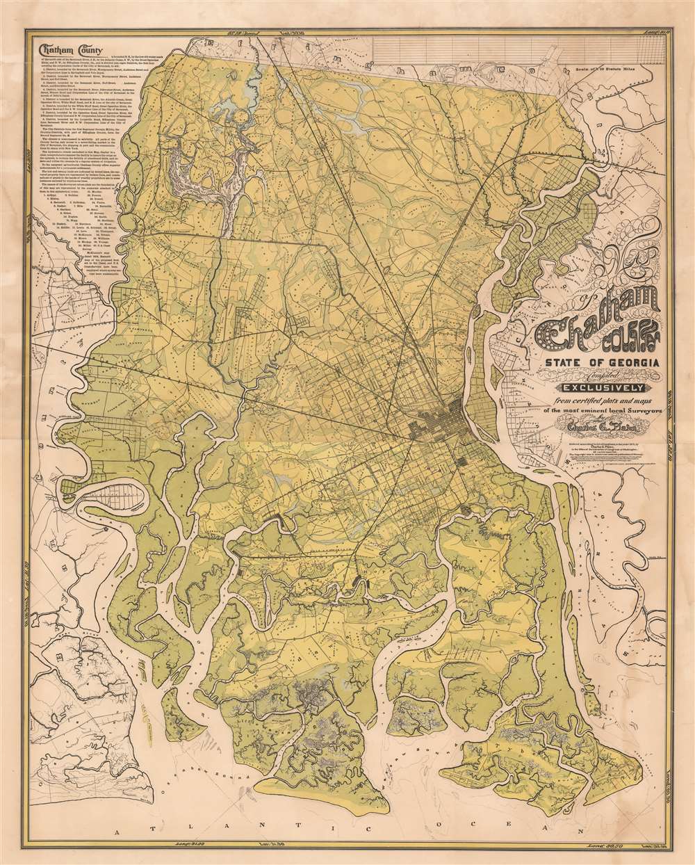

FOR THE ORIGINAL ANTIQUE MAP, WITH HISTORICAL ANALYSIS, CLICK HERE.
Digital Map Information
Geographicus maintains an archive of high-resolution rare map scans. We scan our maps at 300 DPI or higher, with newer images being 600 DPI, (either TIFF or JPEG, depending on when the scan was done) which is most cases in suitable for enlargement and printing.
Delivery
Once you purchase our digital scan service, you will receive a download link via email - usually within seconds. Digital orders are delivered as ZIP files, an industry standard file compression protocol that any computer should be able to unpack. Some of our files are very large, and can take some time to download. Most files are saved into your computer's 'Downloads' folder. All delivery is electronic. No physical product is shipped.
Credit and Scope of Use
You can use your digial image any way you want! Our digital images are unrestricted by copyright and can be used, modified, and published freely. The textual description that accompanies the original antique map is not included in the sale of digital images and remains protected by copyright. That said, we put significant care and effort into scanning and editing these maps, and we’d appreciate a credit when possible. Should you wish to credit us, please use the following credit line:
Courtesy of Geographicus Rare Antique Maps (http://www.geographicus.com).
How Large Can I Print?
In general, at 300 DPI, you should at least be able to double the size of the actual image, more so with our 600 DPI images. So, if the original was 10 x 12 inches, you can print at 20 x 24 inches, without quality loss. If your display requirements can accommodate some loss in image quality, you can make it even larger. That being said, no quality of scan will allow you to blow up at 10 x 12 inch map to wall size without significant quality loss. For more information, it is best consult a printer or reprographics specialist.
Refunds
If the high resolution image you ordered is unavailable, we will fully refund your purchase. Otherwise, digital images scans are a service, not a tangible product, and cannot be returned or refunded once the download link is used.
Charles G. Platen (1818 - 1884) was a German-born Savannah Georgia based architect, lawyer, 'daguerrian artist,' possibly a hatmaker, and map publisher active in the second half of the 19th century. Platen was born in Brunswick, Germany. Evidence suggest his birth name was Moritz Karl Gottfried Von Platen. He may have shortened it to Charles when he emigrated to the United States in 1848, Forty-Eighter fleeing the Revolutions of 1848. He landed in New Orleans in November of that year. Between his arrival and September of 1859, when he settled in Savannah, Georgia, Platen appears to have moved around a bit, settling briefly in Buffalo, New York and later in Charleston, South Carolina, where he worked as a daguerreotype artist. During the American Civil War (1861 - 1865), where he served in the Olmstead's 1st Regiment, Georgia Infantry, and was posted on Sullivan's Island, South Carolina. He declared his intent to become naturalized U.S. Citizen on December 18, 1871. He appears in Savannah directories, where he is listed as an 'architect and lawyer' until 1884. He had at least one child, Hugo Platen (1859 - 1925), who was born in Charleston, in 1859. The 1860 census also records a Pauline Platen (1838 - 18??), born in Hamburg. If our association of Charles G. Platen with Moritz Karl Gottfried Von Platen is correct, this is his much younger wife Pauline Ernestine Friederike Von Platen. In March of 1884, Platen received his naturalization papers. His signature on these documents represent an extremely weak and shaky hand, suggesting infirmity. There is no evidence of Platen after 1884, but there is some suggestion that he may have returned to Germany to visit or live in that year, and may have died there. More by this mapmaker...
Copyright © 2025 Geographicus Rare Antique Maps | Geographicus Rare Antique Maps
This copy is copyright protected.
Copyright © 2025 Geographicus Rare Antique Maps