This copy is copyright protected.
Copyright © 2025 Geographicus Rare Antique Maps
Digital Image: 1879 Texas General Land Office Map of Cherokee County, Texas
CherokeeCounty-texasglo-1879_d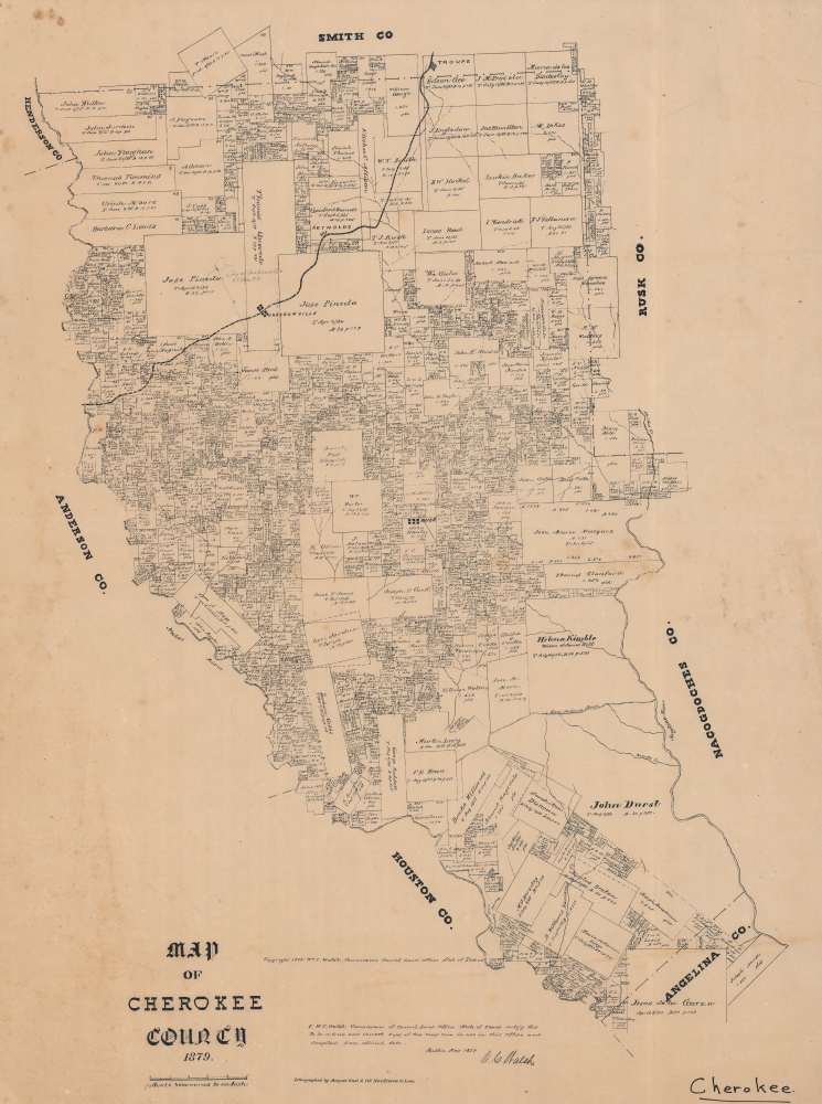

FOR THE ORIGINAL ANTIQUE MAP, WITH HISTORICAL ANALYSIS, CLICK HERE.
Digital Map Information
Geographicus maintains an archive of high-resolution rare map scans. We scan our maps at 300 DPI or higher, with newer images being 600 DPI, (either TIFF or JPEG, depending on when the scan was done) which is most cases in suitable for enlargement and printing.
Delivery
Once you purchase our digital scan service, you will receive a download link via email - usually within seconds. Digital orders are delivered as ZIP files, an industry standard file compression protocol that any computer should be able to unpack. Some of our files are very large, and can take some time to download. Most files are saved into your computer's 'Downloads' folder. All delivery is electronic. No physical product is shipped.
Credit and Scope of Use
You can use your digial image any way you want! Our digital images are unrestricted by copyright and can be used, modified, and published freely. The textual description that accompanies the original antique map is not included in the sale of digital images and remains protected by copyright. That said, we put significant care and effort into scanning and editing these maps, and we’d appreciate a credit when possible. Should you wish to credit us, please use the following credit line:
Courtesy of Geographicus Rare Antique Maps (http://www.geographicus.com).
How Large Can I Print?
In general, at 300 DPI, you should at least be able to double the size of the actual image, more so with our 600 DPI images. So, if the original was 10 x 12 inches, you can print at 20 x 24 inches, without quality loss. If your display requirements can accommodate some loss in image quality, you can make it even larger. That being said, no quality of scan will allow you to blow up at 10 x 12 inch map to wall size without significant quality loss. For more information, it is best consult a printer or reprographics specialist.
Refunds
If the high resolution image you ordered is unavailable, we will fully refund your purchase. Otherwise, digital images scans are a service, not a tangible product, and cannot be returned or refunded once the download link is used.
The Texas General Land Office (GLO) (December 22, 1836 - Present) is an agency of the state government of Texas responsible for the management of land and mineral rights that are owned by the state. Established by the Congress of the Republic of Texas on December 22, 1836, the agency manages Texas's publicly owned land, negotiates and enforces leases concerning the use of that land, and sells public lands. Part of these proceeds are put into the state's Permanent School Fund, which helps fund public education in Texas. The GLO has managed The Alamo in San Antonio since 2011. After Texas was annexed by the United States in 1845, the state maintained control over all its public lands from when it had been a sovereign state, making Texas the only U.S. state to control all its own public lands. All federal land in Texas was acquired either through purchase (for example military bases) or donation (national parks). More by this mapmaker...
August Herman Ludwig Gast (March 10, 1819 - December 24, 1891) was a German-American lithographer. Born in Lippe Detmold, Germany, was educated there, and went into the lithography business with his brother Leopold (March 11, 1810 - March 1, 1898). After participating in the Revolution of 1848, the brothers emigrated to the United States and arrived in New Orleans and, of course, they brought their lithography press with them. them. The duo worked in New York City for a few months, and then spent over a year in Pittsburgh before settling in St. Louis, Missouri in 1852. In St. Louis the brothers founded Leopold Gast and Brother Lighograph Company, which Leopold ran until he sold his share of the business to August in 1866. After Leopold's departure, Gast continued to grow his lithography business, now called August Gast and Company, until he sold it in 1885, when it was one of the largest firms of its kind in the country. After the sale, Gast founded the August Gast Bank Note and Lithograph Company and the Gast Wine Company. Gast died of 'la grippe' in St. Louis at the age of 72. He married his wife Sophie von Laer in 1853. Tragically, Sophie died in 1864. At some point thereafter, Gast married Marie Barthel, with whom he had thirteen children, of whom only four were alive at the time of August Gast's death. Following Gast's death, his son Ferdinand takes over the businesses, and the Gast Wine Company is absorbed by the Gast Brewing Company in 1900. The Gasts continue to prosper and found the Gast Building and Realty Company in 1944, and Ferdinand's grandsons, Ferd Gast and Robert Gast, invest in and develop real estate. Robert created several companies over his lifetime, including those that invest in single family homes and ones to develop, build, and operate amusement parks. Doug Gast, Robert's son, stars a financial investmentsd business in the 1960s, followed by Gast Webbing Restraints in the 1980s, which manufactured automotive parts. By the 2000s, the third generation of Gasts are involved in the family real estate business, and today Gast Companies has consolidated in order to manage their diverse portfolio. Learn More...
Copyright © 2025 Geographicus Rare Antique Maps | Geographicus Rare Antique Maps
This copy is copyright protected.
Copyright © 2025 Geographicus Rare Antique Maps