This copy is copyright protected.
Copyright © 2025 Geographicus Rare Antique Maps
Digital Image: 1784 Roberts Map of the World w/ Cook's Voyages
CookWorld-roberts-1784_d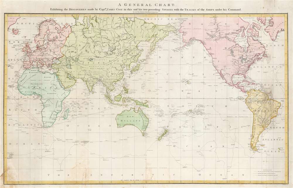

FOR THE ORIGINAL ANTIQUE MAP, WITH HISTORICAL ANALYSIS, CLICK HERE.
Digital Map Information
Geographicus maintains an archive of high-resolution rare map scans. We scan our maps at 300 DPI or higher, with newer images being 600 DPI, (either TIFF or JPEG, depending on when the scan was done) which is most cases in suitable for enlargement and printing.
Delivery
Once you purchase our digital scan service, you will receive a download link via email - usually within seconds. Digital orders are delivered as ZIP files, an industry standard file compression protocol that any computer should be able to unpack. Some of our files are very large, and can take some time to download. Most files are saved into your computer's 'Downloads' folder. All delivery is electronic. No physical product is shipped.
Credit and Scope of Use
You can use your digial image any way you want! Our digital images are unrestricted by copyright and can be used, modified, and published freely. The textual description that accompanies the original antique map is not included in the sale of digital images and remains protected by copyright. That said, we put significant care and effort into scanning and editing these maps, and we’d appreciate a credit when possible. Should you wish to credit us, please use the following credit line:
Courtesy of Geographicus Rare Antique Maps (http://www.geographicus.com).
How Large Can I Print?
In general, at 300 DPI, you should at least be able to double the size of the actual image, more so with our 600 DPI images. So, if the original was 10 x 12 inches, you can print at 20 x 24 inches, without quality loss. If your display requirements can accommodate some loss in image quality, you can make it even larger. That being said, no quality of scan will allow you to blow up at 10 x 12 inch map to wall size without significant quality loss. For more information, it is best consult a printer or reprographics specialist.
Refunds
If the high resolution image you ordered is unavailable, we will fully refund your purchase. Otherwise, digital images scans are a service, not a tangible product, and cannot be returned or refunded once the download link is used.
Henry Roberts (1756 - August 25, 1796) was a British naval officer, cartographer, and explorer active in the second half of the 18th century. He was born in Shoreham-by-Sea, West Sussex, England and baptized on March 17, 1757. Roberts first went to sea in 1771/2 when he was just 16. Roberts is best known for serving with Captain James Cook's on both his second and third voyages of discovery as a master's mate and lieutenant on the H.M.S. Resolution and then on the H.M.S. Discovery. During his time with Cook, Roberts was charged with organizing and maintaining hydrographic and cartographic data under Cook's instruction. After Cook's death and Robert's return to England, he spent the subsequent several years (1781 - 1784) compiling maps for the posthumous atlas of Cook's voyages. His most important map is arguably Cook's 'Lost Chart,' a map of the north Atlantic published by William Faden containing more detailed information related to the Cook voyage as well as the first publication of Herne's discoveries along the Coppermine River. From, 1784 to 1788 he commanded the H.M.S. Speedwell in an effort to curb smuggling int eh English Channel. He the process he apprehended several famous smugglers, including the notorious Pye Happs. In 1789 Roberts was appointed commander of a newly built H.M.S. Discovery and commissioned to follow-up on Cook's work with a. new circumnavigation of discovery. Unfortunately, the Nootka Crises (1789), a political dispute between the Spain, Great Britain, and the United States, derailed the proposed voyage. When the Nootka Crises was resolved, and the voyage reinstituted, Roberts was passed over for command in favor of George Vancouver. Roberts, instead, was sent to the Jamaica in the West Indies as commander of the H.M.S. Undaunted, where he died of Yellow Fever. Vancouver named Point Roberts on the northern tip of Washington State in his honor. More by this mapmaker...
Captain James Cook (7 November 1728 - 14 February 1779) is a seminal figure in the history of cartography for which we can offer only a cursory treatment here. Cook began sailing as a teenager in the British Merchant Navy before joining the Royal Navy in 1755. He was posted in America for a time where he worked Samuel Holland, William Bligh, and others in the mapping of the St. Lawrence River and Newfoundland. In 1766 Cook was commissioned to explore the Pacific and given a Captaincy with command of the Endeavour. What followed were three historic voyages of discovery, the highlights of which include the first European contact with eastern Australia, the discovery of the Hawaiian Islands (among many other Polynesian groups), the first circumnavigation of New Zealand, some of the first sightings of Antarctica, the first accurate mapping of the Pacific Northwest, and ultimately his own untimely death at the hands of angry Hawaiians in 1779. The influence of Cook work on the mapping and exploration of the Pacific cannot be understated. Learn More...
William Palmer (March 4, 1739 - November 1812) was a British engraver, gun engraver, mapmaker, and globemaker active in London in the late 18th century. Palmer was born in London, the son of William Palmer Sr., a pants maker. He was apprenticed to the goldsmith and engraver John Pine in 1753. When Pine died in 1757, his apprenticeship was transferred to the prominent engraver Richard William Seale (1703 - 1762). Palmer flourished under seal's guidance, marring Mary Seale, his master's youngest daughter in 1762. In that same year, he took over Seale's workshop, becoming a prominent engraver in his own right. From 1780 to 1790 he partnered with the globe maker John Newton (1758 - 1844). After 1790 he separated from Newton, partnered with his son, John Palmer, establishing the imprint of William and john Palmer. He notable engraved some of the charts for the official account of Cook's voyages, as well as charts for William Faden, Robert Sayer, Alexander Dalrymple, Laurie and Whittle, and Robert Wilkinson. Palmer is also known in gun collecting and furniture circles for his fine metal engraving work, which can be seen on John Channon furniture, among others. Learn More...
Copyright © 2025 Geographicus Rare Antique Maps | Geographicus Rare Antique Maps
This copy is copyright protected.
Copyright © 2025 Geographicus Rare Antique Maps