This copy is copyright protected.
Copyright © 2025 Geographicus Rare Antique Maps
Digital Image: 1747 La Feuille Map of Dauphine ( Isère, Drôme, and Hautes-Alpes), France
Dauphine-ratelband-1747_d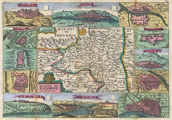

FOR THE ORIGINAL ANTIQUE MAP, WITH HISTORICAL ANALYSIS, CLICK HERE.
Digital Map Information
Geographicus maintains an archive of high-resolution rare map scans. We scan our maps at 300 DPI or higher, with newer images being 600 DPI, (either TIFF or JPEG, depending on when the scan was done) which is most cases in suitable for enlargement and printing.
Delivery
Once you purchase our digital scan service, you will receive a download link via email - usually within seconds. Digital orders are delivered as ZIP files, an industry standard file compression protocol that any computer should be able to unpack. Some of our files are very large, and can take some time to download. Most files are saved into your computer's 'Downloads' folder. All delivery is electronic. No physical product is shipped.
Credit and Scope of Use
You can use your digial image any way you want! Our digital images are unrestricted by copyright and can be used, modified, and published freely. The textual description that accompanies the original antique map is not included in the sale of digital images and remains protected by copyright. That said, we put significant care and effort into scanning and editing these maps, and we’d appreciate a credit when possible. Should you wish to credit us, please use the following credit line:
Courtesy of Geographicus Rare Antique Maps (http://www.geographicus.com).
How Large Can I Print?
In general, at 300 DPI, you should at least be able to double the size of the actual image, more so with our 600 DPI images. So, if the original was 10 x 12 inches, you can print at 20 x 24 inches, without quality loss. If your display requirements can accommodate some loss in image quality, you can make it even larger. That being said, no quality of scan will allow you to blow up at 10 x 12 inch map to wall size without significant quality loss. For more information, it is best consult a printer or reprographics specialist.
Refunds
If the high resolution image you ordered is unavailable, we will fully refund your purchase. Otherwise, digital images scans are a service, not a tangible product, and cannot be returned or refunded once the download link is used.
Daniel de La Feuille (1640 - 1709) was born of Huguenot stock in Sedan (L'Ardennes), France. As a young man he apprenticed as a watchmaker. In 1663 La Feuille married Charlette Marlet, the daughter of a local carpenter. Twenty years later, in 1683, facing religious prosecution of Huguenots in France, the family fled to Amsterdam. By 1686 Daniel had become a burgher (citizen) of the city and established himself as an engraver, publisher, and art dealer. Not long after, in 1691, he was admitted into the Booksellers Guild. Though we are primarily concerned with his cartographic work here, his masterpiece is considered to be Devises et emblems, a collection of symbols and designs mostly likely intended as templates for silversmiths, engravers, and watchmakers. His cartographic work includes numerous individual maps and atlases, many of which continued to be published and republished well after his death in 1709. He was succeeded by his sons Jacob de la Feuille (1668 - 1719) and Paul de La Feuille (1688 - 1727). More by this mapmaker...
Johannes Ratelband (1715 - 1793) was a European map publisher based in Amsterdam. Ratelband is a rather obscure fellow, but is known to have published a series of European maps and views in association with the La Feuille family. Learn More...
Copyright © 2025 Geographicus Rare Antique Maps | Geographicus Rare Antique Maps
This copy is copyright protected.
Copyright © 2025 Geographicus Rare Antique Maps