This copy is copyright protected.
Copyright © 2025 Geographicus Rare Antique Maps
Digital Image: 1866 Mathews View Map of Denver, Colorado
Denver-mathews-1866_d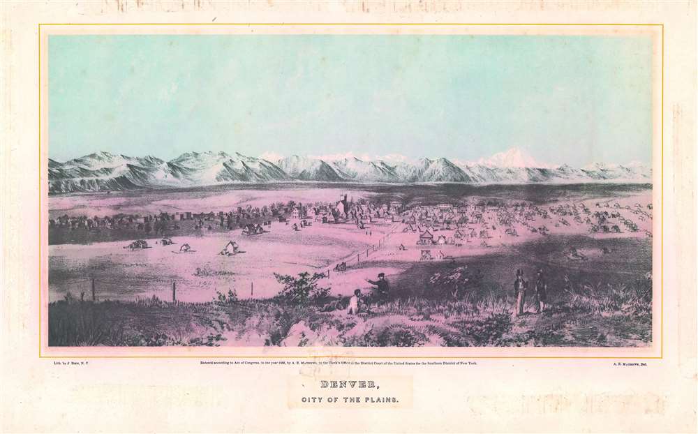

FOR THE ORIGINAL ANTIQUE MAP, WITH HISTORICAL ANALYSIS, CLICK HERE.
Digital Map Information
Geographicus maintains an archive of high-resolution rare map scans. We scan our maps at 300 DPI or higher, with newer images being 600 DPI, (either TIFF or JPEG, depending on when the scan was done) which is most cases in suitable for enlargement and printing.
Delivery
Once you purchase our digital scan service, you will receive a download link via email - usually within seconds. Digital orders are delivered as ZIP files, an industry standard file compression protocol that any computer should be able to unpack. Some of our files are very large, and can take some time to download. Most files are saved into your computer's 'Downloads' folder. All delivery is electronic. No physical product is shipped.
Credit and Scope of Use
You can use your digial image any way you want! Our digital images are unrestricted by copyright and can be used, modified, and published freely. The textual description that accompanies the original antique map is not included in the sale of digital images and remains protected by copyright. That said, we put significant care and effort into scanning and editing these maps, and we’d appreciate a credit when possible. Should you wish to credit us, please use the following credit line:
Courtesy of Geographicus Rare Antique Maps (http://www.geographicus.com).
How Large Can I Print?
In general, at 300 DPI, you should at least be able to double the size of the actual image, more so with our 600 DPI images. So, if the original was 10 x 12 inches, you can print at 20 x 24 inches, without quality loss. If your display requirements can accommodate some loss in image quality, you can make it even larger. That being said, no quality of scan will allow you to blow up at 10 x 12 inch map to wall size without significant quality loss. For more information, it is best consult a printer or reprographics specialist.
Refunds
If the high resolution image you ordered is unavailable, we will fully refund your purchase. Otherwise, digital images scans are a service, not a tangible product, and cannot be returned or refunded once the download link is used.
Alfred Edward Mathews (June 24, 1831 – October 30, 1874) was an English born American artist, author, and illustrator active in the middle part of the 19th century. Mathews was born in Bristol, England in 1831. His family emigrated to the United States and 1833 where they settled in Rochester, Ohio. There Mathews took work as a typesetter in his brother, Charles Mathews; newspaper, the Ohio Democrat. In the 1850s Alfred too new work as a traveling bookseller where he traveled throughout New England. Later in the 1850s he found work as a school teacher in Tuscaloosa County, Alabama. With the outbreak of the Civil War, Mathews returned to Ohio and enlisted in the Union Army, where he served with the 31st Ohio Volunteer Inventory. He participated in the Siege of Corinth and the Battles of Stones River, Lookout Mountain, and Mission Ridge. He proved an able draughtsman and produced topographical maps and views of important war events, including a panorama of Vicksburg. After the war Mathews headed west, settling briefly in Nebraska City before moving on to Denver, where his November 13, 1865 arrival was noted Rocky Mountain News. He began work immediately on a book of views and sketches highlighting the beauty and commercial prosperity of Colorado. The work proved both poplar and influential, earning him additional work in other Colorado cities, Montana, and California. Eventually he settled into a home on the Big Thompson River, west of Boulder. After only a few months there he contracted appendicitis and died on October 30, 1874. More by this mapmaker...
Julius (Julien) Bien (September 27, 1826 - December 21, 1909) was a German-Jewish lithographer and engraver based in New York City. Bien was born in Naumburg, Germany. He was educated at the Academy of Fine Arts, Cassell and at Städel's Institute, Frankfurt-am-Main. Following the suppression of the anti-autocratic German Revolutions of 1848, Bien, who participated in the pan-German movement, found himself out of favor in his home country and joined the mass German immigration to the United States. Bien can be found in New York as early as 1849. He established the New York Lithographing, Engraving & Printing Company in New York that focused on the emergent chromo-lithograph process - a method of printing color using lithographic plates. His work drew the attention of the U.S. Government Printing Office which contracted him to produce countless government maps and surveys, including the Pacific Railroad Surveys, the census, numerous coast surveys, and various maps relating to the American Civil War. Bien also issued several atlases both privately and in conjunction with a relation, Joseph Bien. At the height of his career Bien was elected president of the American Lithographers Association. After his death in 1909, Bien's firm was taken over by his son who promptly ran it into insolvency. The firm was sold to Sheldon Franklin, who, as part of the deal, retained the right to publish under the Julius Bien imprint. In addition to his work as a printer, Bien was active in the New York German Jewish community. He was director of the New York Hebrew Technical Institute, the New York Hebrew Orphan Asylum, and president of the B'nai B'rith Order. Learn More...
Copyright © 2025 Geographicus Rare Antique Maps | Geographicus Rare Antique Maps
This copy is copyright protected.
Copyright © 2025 Geographicus Rare Antique Maps