Digital Image: 1834 Samuel Doughty Cadestral Map of the East Village, New York City
EastVillageStuyvesant-doughty-1834_d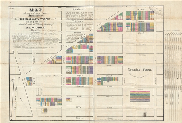

Title
Map shewing a division of part of the real estate late of Nicholas W. Stuyvesant decd. among his heirs situated in the 11th Ward of the City of New York.
1834 (dated) 23 x 35.5 in (58.42 x 90.17 cm) 1 : 1450
1834 (dated) 23 x 35.5 in (58.42 x 90.17 cm) 1 : 1450
Description
FOR THE ORIGINAL ANTIQUE MAP, WITH HISTORICAL ANALYSIS, CLICK HERE.
Digital Map Information
Geographicus maintains an archive of high-resolution rare map scans. We scan our maps at 300 DPI or higher, with newer images being 600 DPI, (either TIFF or JPEG, depending on when the scan was done) which is most cases in suitable for enlargement and printing.
Delivery
Once you purchase our digital scan service, you will receive a download link via email - usually within seconds. Digital orders are delivered as ZIP files, an industry standard file compression protocol that any computer should be able to unpack. Some of our files are very large, and can take some time to download. Most files are saved into your computer's 'Downloads' folder. All delivery is electronic. No physical product is shipped.
Credit and Scope of Use
You can use your digial image any way you want! Our digital images are unrestricted by copyright and can be used, modified, and published freely. The textual description that accompanies the original antique map is not included in the sale of digital images and remains protected by copyright. That said, we put significant care and effort into scanning and editing these maps, and we’d appreciate a credit when possible. Should you wish to credit us, please use the following credit line:
Courtesy of Geographicus Rare Antique Maps (http://www.geographicus.com).
How Large Can I Print?
In general, at 300 DPI, you should at least be able to double the size of the actual image, more so with our 600 DPI images. So, if the original was 10 x 12 inches, you can print at 20 x 24 inches, without quality loss. If your display requirements can accommodate some loss in image quality, you can make it even larger. That being said, no quality of scan will allow you to blow up at 10 x 12 inch map to wall size without significant quality loss. For more information, it is best consult a printer or reprographics specialist.
Refunds
If the high resolution image you ordered is unavailable, we will fully refund your purchase. Otherwise, digital images scans are a service, not a tangible product, and cannot be returned or refunded once the download link is used.
Cartographer
Samuel Stillwell Doughty (1810 - July, 1888) was a New York City surveyor active in the middle part of the 19th century. Doughty was the son of another New York City Surveyor, Edward Doughty (1789 - 1863), from whom he learnt the trade. Doughty produced numerous city surveys and cadastral maps used for property transfers and legal disputes. From 1844 to about 1846 he also held the position of New York City Street Commissioner. Samuel was highly significant in the early development of New York City. He laid out may of the streets in upper New York as well as assisted on the initial surveys of Central Park. In 1880 he published short biography of his father, Edward Doughty. He resided on 28th Street near Broadway, New York City. More by this mapmaker...
References
OCLC 58661108. Columbia University, Seymour B. Durst Old York Library, AA735 N4 D75 FFF. Clio 10390845.