This copy is copyright protected.
Copyright © 2025 Geographicus Rare Antique Maps
Digital Image: 1830 Seaton Large-Format Case Map of England and Wales
EnglandWales-seaton-1830_d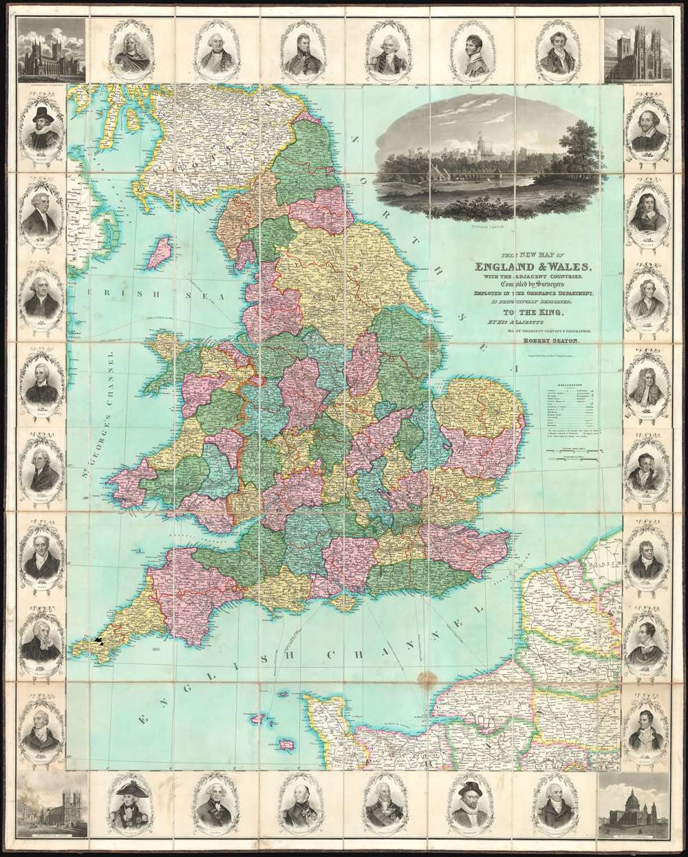

FOR THE ORIGINAL ANTIQUE MAP, WITH HISTORICAL ANALYSIS, CLICK HERE.
Digital Map Information
Geographicus maintains an archive of high-resolution rare map scans. We scan our maps at 300 DPI or higher, with newer images being 600 DPI, (either TIFF or JPEG, depending on when the scan was done) which is most cases in suitable for enlargement and printing.
Delivery
Once you purchase our digital scan service, you will receive a download link via email - usually within seconds. Digital orders are delivered as ZIP files, an industry standard file compression protocol that any computer should be able to unpack. Some of our files are very large, and can take some time to download. Most files are saved into your computer's 'Downloads' folder. All delivery is electronic. No physical product is shipped.
Credit and Scope of Use
You can use your digial image any way you want! Our digital images are unrestricted by copyright and can be used, modified, and published freely. The textual description that accompanies the original antique map is not included in the sale of digital images and remains protected by copyright. That said, we put significant care and effort into scanning and editing these maps, and we’d appreciate a credit when possible. Should you wish to credit us, please use the following credit line:
Courtesy of Geographicus Rare Antique Maps (http://www.geographicus.com).
How Large Can I Print?
In general, at 300 DPI, you should at least be able to double the size of the actual image, more so with our 600 DPI images. So, if the original was 10 x 12 inches, you can print at 20 x 24 inches, without quality loss. If your display requirements can accommodate some loss in image quality, you can make it even larger. That being said, no quality of scan will allow you to blow up at 10 x 12 inch map to wall size without significant quality loss. For more information, it is best consult a printer or reprographics specialist.
Refunds
If the high resolution image you ordered is unavailable, we will fully refund your purchase. Otherwise, digital images scans are a service, not a tangible product, and cannot be returned or refunded once the download link is used.
Robert Seaton (fl. c. 1835 - 1836) was a British mapmaker who held the post of Hydrographer to the King. Despite the impressive title, we are only able to identify two maps by Seaton, Seaton's Map of Palestine and the Holy Land, and a New Map of England and Wales, both engraved by Josiah Neele (1804 - 1876) and published in 1835. More by this mapmaker...
Josiah Neele (March 30, 1804 - March 22, 1876) was a British map engraver, printer, and publisher active in London during the middle part of the 19th century. Neele was the son of Samuel John Neele (1758 - 1824), also a prominent map engraver. He apprenticed under his father along with Ebenezer Stalker (1780 - 1847) with whom he briefly partnered until 1825. At that time, he went into business with his uncle, George Neele, and his brother, James Neele. George retired in 1826, ending that partnership, after which the brothers published until 1929 under the imprint of 'James and Josiah Neele'. Josiah subsequently continued the business under his own name, operating from their former offices at 352 Strand, until 1836, when he declared bankruptcy. In 1845 he married Eliza Atwood of Haverfordwest and in the wedding documents he is described as a stationer. He retired to Wiltshire in 1871 and died five years later in 1876. Learn More...
Copyright © 2025 Geographicus Rare Antique Maps | Geographicus Rare Antique Maps
This copy is copyright protected.
Copyright © 2025 Geographicus Rare Antique Maps