This copy is copyright protected.
Copyright © 2025 Geographicus Rare Antique Maps
Digital Image: 1834 Lucy Durfee Manuscript Schoolgirl Map of Europe
Europe-durfee-1834_d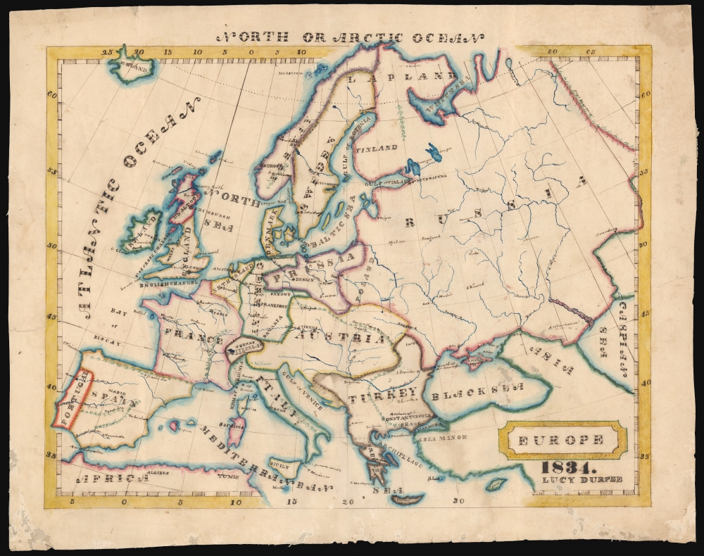

FOR THE ORIGINAL ANTIQUE MAP, WITH HISTORICAL ANALYSIS, CLICK HERE.
Digital Map Information
Geographicus maintains an archive of high-resolution rare map scans. We scan our maps at 300 DPI or higher, with newer images being 600 DPI, (either TIFF or JPEG, depending on when the scan was done) which is most cases in suitable for enlargement and printing.
Delivery
Once you purchase our digital scan service, you will receive a download link via email - usually within seconds. Digital orders are delivered as ZIP files, an industry standard file compression protocol that any computer should be able to unpack. Some of our files are very large, and can take some time to download. Most files are saved into your computer's 'Downloads' folder. All delivery is electronic. No physical product is shipped.
Credit and Scope of Use
You can use your digial image any way you want! Our digital images are unrestricted by copyright and can be used, modified, and published freely. The textual description that accompanies the original antique map is not included in the sale of digital images and remains protected by copyright. That said, we put significant care and effort into scanning and editing these maps, and we’d appreciate a credit when possible. Should you wish to credit us, please use the following credit line:
Courtesy of Geographicus Rare Antique Maps (http://www.geographicus.com).
How Large Can I Print?
In general, at 300 DPI, you should at least be able to double the size of the actual image, more so with our 600 DPI images. So, if the original was 10 x 12 inches, you can print at 20 x 24 inches, without quality loss. If your display requirements can accommodate some loss in image quality, you can make it even larger. That being said, no quality of scan will allow you to blow up at 10 x 12 inch map to wall size without significant quality loss. For more information, it is best consult a printer or reprographics specialist.
Refunds
If the high resolution image you ordered is unavailable, we will fully refund your purchase. Otherwise, digital images scans are a service, not a tangible product, and cannot be returned or refunded once the download link is used.
Lucy Durfee (Borden) (January 18, 1821 - July 26, 1890) was a Rhode Islander; she was born, lived, and died in Tiverton near Newport. Her father, The Hon. Job Durfee, LL.D. (1790 - 1847), was a lawyer, state legislator, a federalist congressman, a poet, and author. Lucy, the eldest of seven siblings - at least one of whom was an author as well - would have been brought up in a literate and studious household. While she appears to have published nothing, in her youth she would have been educated in the early American vein, intended to make her better able to raise a generation of literate, politically intelligent young Americans. As evidence of this, there are no fewer than four 'schoolgirl' maps in her hand that have survived. In 1846 she married Thomas Hicks Borden, with whom she raised at least eight children, to whom it is to be hoped that she passed along her studiousness and curiosity. More by this mapmaker...
Jesse Olney (1798 - 1872) was an American geographer, primarily active and successful in the production of school textbooks on that subject. His sales were second only to thos of Webster's American Spelling Book. He was educated in Whitesboro, New York, and would work as a teacher both there and in Binghamton. From 1819 to 1831 he served as principal of the Stone School in Hartford, Connecticut. In 1828 he published A Geography and Atlas, which for thirty years would be the standard geographical text used throughout the United States. It was many times enlarged and revised, and ran through 98 editions. While prior geographies opened with a description of astronomy and the solar system - a convention harkening back to Ptolemy, and the discipline of cosmography - Olney chose instead to center his pedagogy on the student's home town, expanding instead from there. The intention was to guide the student in study of the Earth by moving from that which was near and familiar to what was distant and abstract. He would later expand his repertoire of textbooks to include readers, arithmetic books, and United States history. He would enter the Connecticut legislature, using his position to influence the development of that state's schools. A Unitarian, he would be also active in advocacy for the liberal religious movements in New England. Learn More...
Copyright © 2025 Geographicus Rare Antique Maps | Geographicus Rare Antique Maps
This copy is copyright protected.
Copyright © 2025 Geographicus Rare Antique Maps