This copy is copyright protected.
Copyright © 2025 Geographicus Rare Antique Maps
Digital Image: 1801 Depot de la Marine Nautical Map of Florida, Cuba, Bahamas, Santo Domingo
FloridaGreaterAntilles-depotdelamarine-1801_d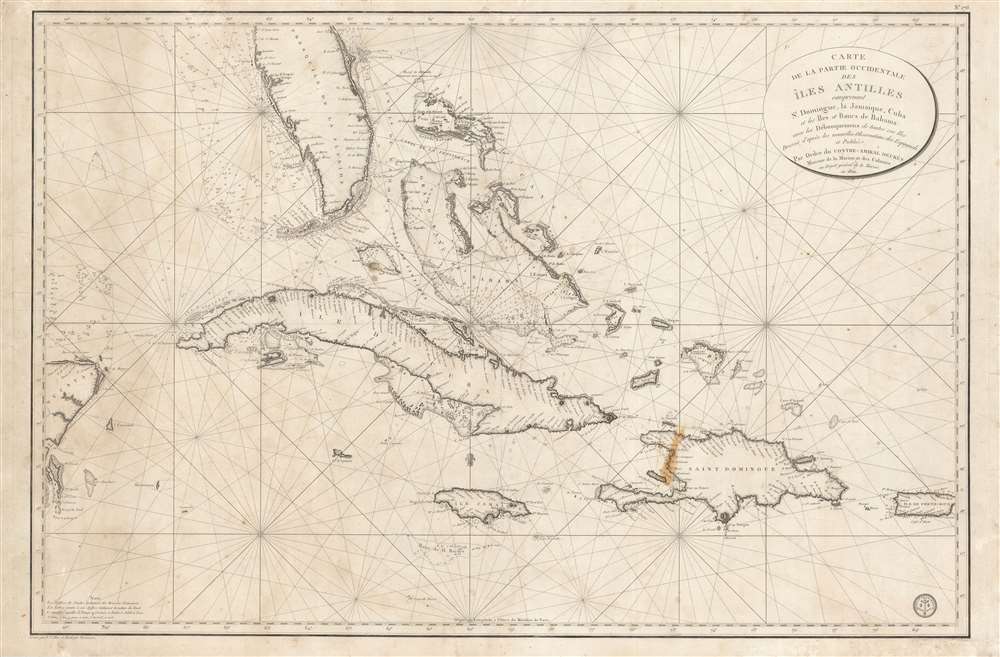

FOR THE ORIGINAL ANTIQUE MAP, WITH HISTORICAL ANALYSIS, CLICK HERE.
Digital Map Information
Geographicus maintains an archive of high-resolution rare map scans. We scan our maps at 300 DPI or higher, with newer images being 600 DPI, (either TIFF or JPEG, depending on when the scan was done) which is most cases in suitable for enlargement and printing.
Delivery
Once you purchase our digital scan service, you will receive a download link via email - usually within seconds. Digital orders are delivered as ZIP files, an industry standard file compression protocol that any computer should be able to unpack. Some of our files are very large, and can take some time to download. Most files are saved into your computer's 'Downloads' folder. All delivery is electronic. No physical product is shipped.
Credit and Scope of Use
You can use your digial image any way you want! Our digital images are unrestricted by copyright and can be used, modified, and published freely. The textual description that accompanies the original antique map is not included in the sale of digital images and remains protected by copyright. That said, we put significant care and effort into scanning and editing these maps, and we’d appreciate a credit when possible. Should you wish to credit us, please use the following credit line:
Courtesy of Geographicus Rare Antique Maps (http://www.geographicus.com).
How Large Can I Print?
In general, at 300 DPI, you should at least be able to double the size of the actual image, more so with our 600 DPI images. So, if the original was 10 x 12 inches, you can print at 20 x 24 inches, without quality loss. If your display requirements can accommodate some loss in image quality, you can make it even larger. That being said, no quality of scan will allow you to blow up at 10 x 12 inch map to wall size without significant quality loss. For more information, it is best consult a printer or reprographics specialist.
Refunds
If the high resolution image you ordered is unavailable, we will fully refund your purchase. Otherwise, digital images scans are a service, not a tangible product, and cannot be returned or refunded once the download link is used.
Dépôt des Cartes et Plans de la Marine (fl. 1720 - present), often called the Dépôt de Marine, was a French hydrographic mapping organization founded in 1720 under Charles-Hercule of Albert de Luynes (1674 - 1734). Much like the U.S. Coast Survey, the British Admiralty, and the Spanish Deposito Hydrografico, the Dépôt was initiated as a storehouse and distribution center of existing nautical and marine charts. Eventually the Dépôt initiated its own mapping activities in an attempt to improve and expand upon existing material. Some of the more prominent cartographers and hydrographers associated with the of Dépôt des Cartes were, Philippe Buache, Jacques-Nicholas Bellin, Giovanni Rizzi-Zannoni, Rigobert Bonne, and Jean Nicolas Buache. More by this mapmaker...
Charles-Étienne Collin (1770 - 1840) was a French engraver active in Paris during the late 18th and early 19th centuries. Collin was born in Paris to a long line of important French engravers dating back to Jean Collin. He was the son of Bernard Collin (1737 - 1791), son of Jean. Collin engraved for the seminal 1809 - 1822 Description de l'Egypte and extensively for the Dépôt de la Marine. His was contracted by his cousin by marriage, Phillipe Buache (February 7, 1700 - January 24, 1773) for his exceptional engraving mastery to work for the Dépôt de la Marine from at least August 1793. He worked with his brother, Jean-Louis Collin (1775 - 1858), from 1800 to 1803. His son, also Charles-Étienne Collin or possibly just Étienne Collin II (1790 - 1852), apprenticed under him and worked with him from 1821 to 1829. Under Charles-Étienne Collin (1770 - 1840) and then his son, the firm was located in Paris at N° 45, Rue de la Harpe. The last known work attributed to 'E. Collin' appeared in 1831. Distinguishing between the 'Collin' family of engravers on Dépôt de la Marine is difficult. The elder Étienne Collin (1770 - 1840) typically signed his work 'E. Collin' or later 'E. Collin père'. His son signs some of his work as 'E. Collin' and others as 'C.E. Collin fils.' There is some evidence of another generation of Collin engravers, also Charles-Étienne Collin, signing his work as 'C. E. Collin' between 1840 and 1875. Learn More...
J.P. Besançon (fl. c. 1798 - 1835) was a French engraver who specialized in lettering. Besançon began engraving nautical charts for Charles-François Beautemps-Beaupré (August 6, 1766 - March 16, 1854) in 1802. He engraved eighty-three maps for Beautemps-Beaupré, then the hydrographer in chief, between 1802 and 1831, when he handed off the work to J.M. Hacq. Little else is known about Besançon's life and career. Learn More...
Copyright © 2025 Geographicus Rare Antique Maps | Geographicus Rare Antique Maps
This copy is copyright protected.
Copyright © 2025 Geographicus Rare Antique Maps