This copy is copyright protected.
Copyright © 2025 Geographicus Rare Antique Maps
Digital Image: 1892 Proof State U.S. Navy Map of Honolulu Harbor, w/manuscript corrections
Honolulu-wiltse-1892_d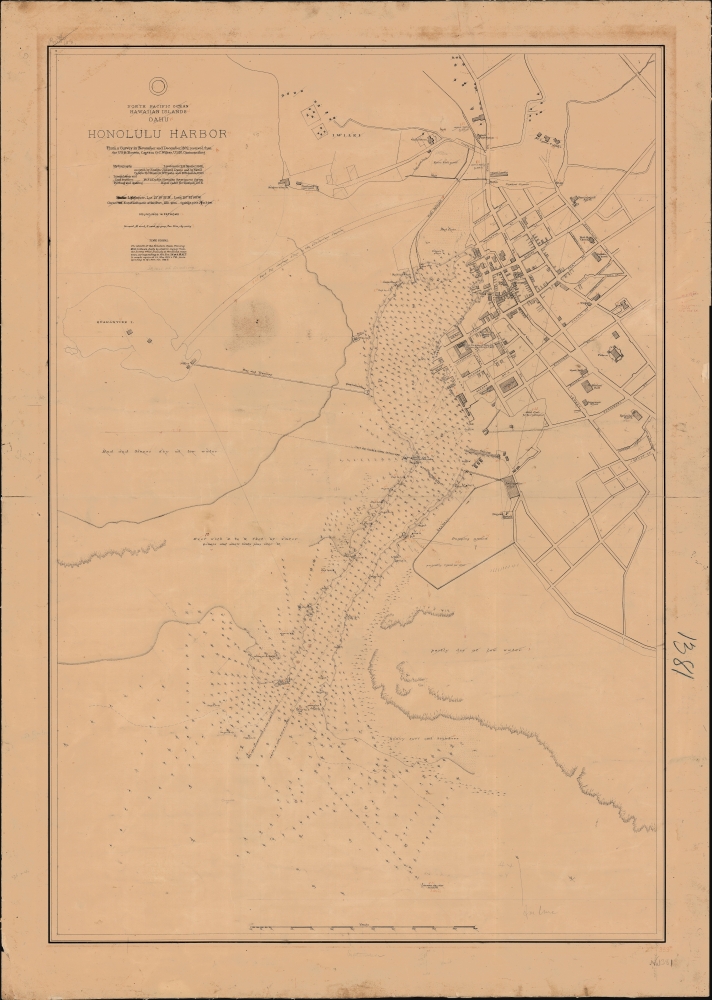


FOR THE ORIGINAL ANTIQUE MAP, WITH HISTORICAL ANALYSIS, CLICK HERE.
Digital Map Information
Geographicus maintains an archive of high-resolution rare map scans. We scan our maps at 300 DPI or higher, with newer images being 600 DPI, (either TIFF or JPEG, depending on when the scan was done) which is most cases in suitable for enlargement and printing.
Delivery
Once you purchase our digital scan service, you will receive a download link via email - usually within seconds. Digital orders are delivered as ZIP files, an industry standard file compression protocol that any computer should be able to unpack. Some of our files are very large, and can take some time to download. Most files are saved into your computer's 'Downloads' folder. All delivery is electronic. No physical product is shipped.
Credit and Scope of Use
You can use your digial image any way you want! Our digital images are unrestricted by copyright and can be used, modified, and published freely. The textual description that accompanies the original antique map is not included in the sale of digital images and remains protected by copyright. That said, we put significant care and effort into scanning and editing these maps, and we’d appreciate a credit when possible. Should you wish to credit us, please use the following credit line:
Courtesy of Geographicus Rare Antique Maps (http://www.geographicus.com).
How Large Can I Print?
In general, at 300 DPI, you should at least be able to double the size of the actual image, more so with our 600 DPI images. So, if the original was 10 x 12 inches, you can print at 20 x 24 inches, without quality loss. If your display requirements can accommodate some loss in image quality, you can make it even larger. That being said, no quality of scan will allow you to blow up at 10 x 12 inch map to wall size without significant quality loss. For more information, it is best consult a printer or reprographics specialist.
Refunds
If the high resolution image you ordered is unavailable, we will fully refund your purchase. Otherwise, digital images scans are a service, not a tangible product, and cannot be returned or refunded once the download link is used.
United States Hydrographic Office (1866 - 1962) was a brach of he U.S. Navy that prepared and published maps, charts, and nautical books to aid in navigation. Before the establishment of the Hydrographic Office in 1866, U.S. navigators were almost entirely dependent on British charts. There had been a few private enterprises that had prepared and published charts, but none had been able to do so profitably. The Office was established 'for the improvement of the means of navigating safely the vessels of the Navy and of the mercantile marine, by providing, under the authority of the Secretary of the Navy, accurate and cheap nautical charts, sailing directions, navigators, and manuals of instructions for the use of all vessels of the United States, and for the benefit and use of navigators generally.' This way the Navy Department could furnish navy and merchant ships with charts illustrating the results of surveys and explorations undertaken by naval officers. The charts were priced to cover the cost of paper and printing alone, not preparation. Its main objective was to survey foreign coasts, as the Coast and Geodetic Surveys were responsible for surveying domestic waters. The Hydrographic Office was transferred from the Department of the Navy to the Department of Defense in 1949 and was replaced by the Naval Oceanographic Office in 1962. More by this mapmaker...
Gilbert Conwall Wiltse (November 29m 1838 - April 26, 1893) was an American naval officer active throughout the 19th century. Wiltse was born in New York and graduated from the Naval Academy in 1855. He served as a midshipman in the Brazilian Station from 1859 - 1861, at which point he was made lieutenant. During the American Civil War (1861 - 1865), he was recalled and was present at the March 8 and 9, 1862 Hampton Roads engagement of the CSS Virginia, with the USS Congress and the USS Cumberland. He also served in the West Indies and as part of the 1863 - 1864 blockading squadron. He was commissioned Lieutenant Commander on March 3rd, 1865. He served in New York and the North Atlantic between and 1885. In 1891, he was put in command of the Boston, and sent around South America into the Pacific. On this voyage, Wiltse had a stroke. Although he appeared to recover, he was never again a strong commander and give indication of mental instability. The Boston was shortly thereafter sent to Hawaii, both to protect American interests there and to survey Honolulu Harbor. Wiltse was in Honolulu when the Hawaiian Revolution broke out and was dispatched with a contingent of marines to defend the U.S. Consulate. He supported the revolution and, according to some reports boldly asserted that he had 'taken Hawaii for the United States'. He returned to New York City immediately after, believing he would be me with parades and presidential accolades. Such might have happened if Harrison remained president, but Grover Cleveland did not support annexation and turned Wiltse away. In fact, the U.S. flags Wiltse so proudly raised over Hawaii were taken down shortly thereafter. It is said that when he heard this new he collapsed into a fit and, aged 54, died of 'congestion of the brain'. Learn More...
Copyright © 2025 Geographicus Rare Antique Maps | Geographicus Rare Antique Maps
This copy is copyright protected.
Copyright © 2025 Geographicus Rare Antique Maps