Digital Image: 1909 Map of John Jay McKelvey's Along-the-Hudson Park in Spuyten Duyvil
HudsonPark-klein-1909_d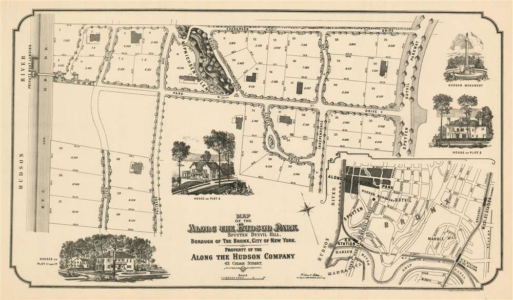

Title
Map of the Along the Hudson Park Spuyten Duyvil Hill, Borough of the Bronx, City of New York. Property of the Along The Hudson Company.
1909 (undated) 16.5 x 29 in (41.91 x 73.66 cm) 1 : 900
1909 (undated) 16.5 x 29 in (41.91 x 73.66 cm) 1 : 900
Description
FOR THE ORIGINAL ANTIQUE MAP, WITH HISTORICAL ANALYSIS, CLICK HERE.
Digital Map Information
Geographicus maintains an archive of high-resolution rare map scans. We scan our maps at 300 DPI or higher, with newer images being 600 DPI, (either TIFF or JPEG, depending on when the scan was done) which is most cases in suitable for enlargement and printing.
Delivery
Once you purchase our digital scan service, you will receive a download link via email - usually within seconds. Digital orders are delivered as ZIP files, an industry standard file compression protocol that any computer should be able to unpack. Some of our files are very large, and can take some time to download. Most files are saved into your computer's 'Downloads' folder. All delivery is electronic. No physical product is shipped.
Credit and Scope of Use
You can use your digial image any way you want! Our digital images are unrestricted by copyright and can be used, modified, and published freely. The textual description that accompanies the original antique map is not included in the sale of digital images and remains protected by copyright. That said, we put significant care and effort into scanning and editing these maps, and we’d appreciate a credit when possible. Should you wish to credit us, please use the following credit line:
Courtesy of Geographicus Rare Antique Maps (http://www.geographicus.com).
How Large Can I Print?
In general, at 300 DPI, you should at least be able to double the size of the actual image, more so with our 600 DPI images. So, if the original was 10 x 12 inches, you can print at 20 x 24 inches, without quality loss. If your display requirements can accommodate some loss in image quality, you can make it even larger. That being said, no quality of scan will allow you to blow up at 10 x 12 inch map to wall size without significant quality loss. For more information, it is best consult a printer or reprographics specialist.
Refunds
If the high resolution image you ordered is unavailable, we will fully refund your purchase. Otherwise, digital images scans are a service, not a tangible product, and cannot be returned or refunded once the download link is used.
Cartographer S
Robert A. Welcke (November 24, 1848 - January 27, 1936) was a photolithographer active in New York in the latter part of the 19th century and early 20th century. Welcke was born in Wronke, today in Poland, but then part of Prussia. He emigrated to New York City in 1869. After settling, Welcke went into the lithography business with his brother, Edward Welcke, who arrived a decade earlier. After a split between the brothers during the economic depression of the late 1870s, Robert Welcke continued in business on his own. Welcke's firm, Robert A. Welcke Offset Company, was based at 176 William Street. His corpus ranges from real estate maps of New York and Connecticut to illustrations on Flemish Renaissance interiors to government maps and brochures to decorative sheet music covers. Following Welcke's death, the firm was taken over by his daughter, Olga Welcke, who, alongside William Jugens, managed it until the outbreak of World War II (1939 - 1945). More by this mapmaker...
William W. Klein (February 9, 1868 - ?) was a German - American civil engineer and surveyor living and working in The Bronx. He was born in Mündelheim, Germany; he joined the cadet corps at 13, was a sergeant by 1887 and rose to the position of Lieutenant in 1890 - though he apppears to have at least visited New York as early as 1889. In any case, he was granted leave in 1897 (Verabschiedet) returning to the United States in 1897 at the age of 29. Klein appears to have begun work as a surveyor and civil engineer right away, working for some years in conjunction with printer Robert Welcke on several maps of the Bronx and New York City overall. In 1906 he was appointed City Surveyor. As of 1913 he was a listed member of the Verband Deutscher Schriftsteller in Amerika (Association of German Writers in America.) The beginning of the first world war saw him return to Germany to take up his commission. He served in the ersatz corps in 1914, being promoted to Oberleutnant. He appears to have survived the war: but we see no evidence of his ever returning to America or his family. Learn More...
John Jay McKelvey (May 24 1863 – October 19 1947) was an American author, attorney, and preservationist who set precedents in case law to stave off urban development of his Spuyten Duyvil community in The Bronx. The neighborhood had long been an enclave for the wealthy, and as the city grew around them residents of the neighborhood joined McKelvey in fighting threats to their park residence district. McKelvey used realty buyouts to protectively develop in such way that would save his picturesque tranquility. In the 20s he would bend so far as to develop idyllic garden apartment buildings like his visionary Villa Charlotte Brontë. Critics suggested that McKelvey's vision was driven by profit and oblivious to the needs of a growing city, although his projects also included the development of the Henry Hudson Monument and Edgehill Terraces. Learn More...
Robert Waterman Gardner (1866 - September 7, 1937) was an American architect noted for pioneering the use of reinforced concrete in residential architecture. He studied architecture with Calvert Vaux and Clarence Luce from 1887 to 1891, and was operating on his own as early as 1905. His 1909 partnership with John Jay McKelvey in developing the 'Along-the-Hudson-Park' in Spuyten Duyvil, New York gave him a broad canvas on which to put his design ideas in practice. Many of the single-family homes built there were made to his designs, and the collaboration would continue into the 1920s with the construction of McKelvey's Villa Rosa Bonheur and Villa Charlotte Bronte. He would become president of the New York Society of Craftsmen. Learn More...