Digital Image: 1576 Porcacchi Map of Iceland
Iceland-porcacchi-1576-2_d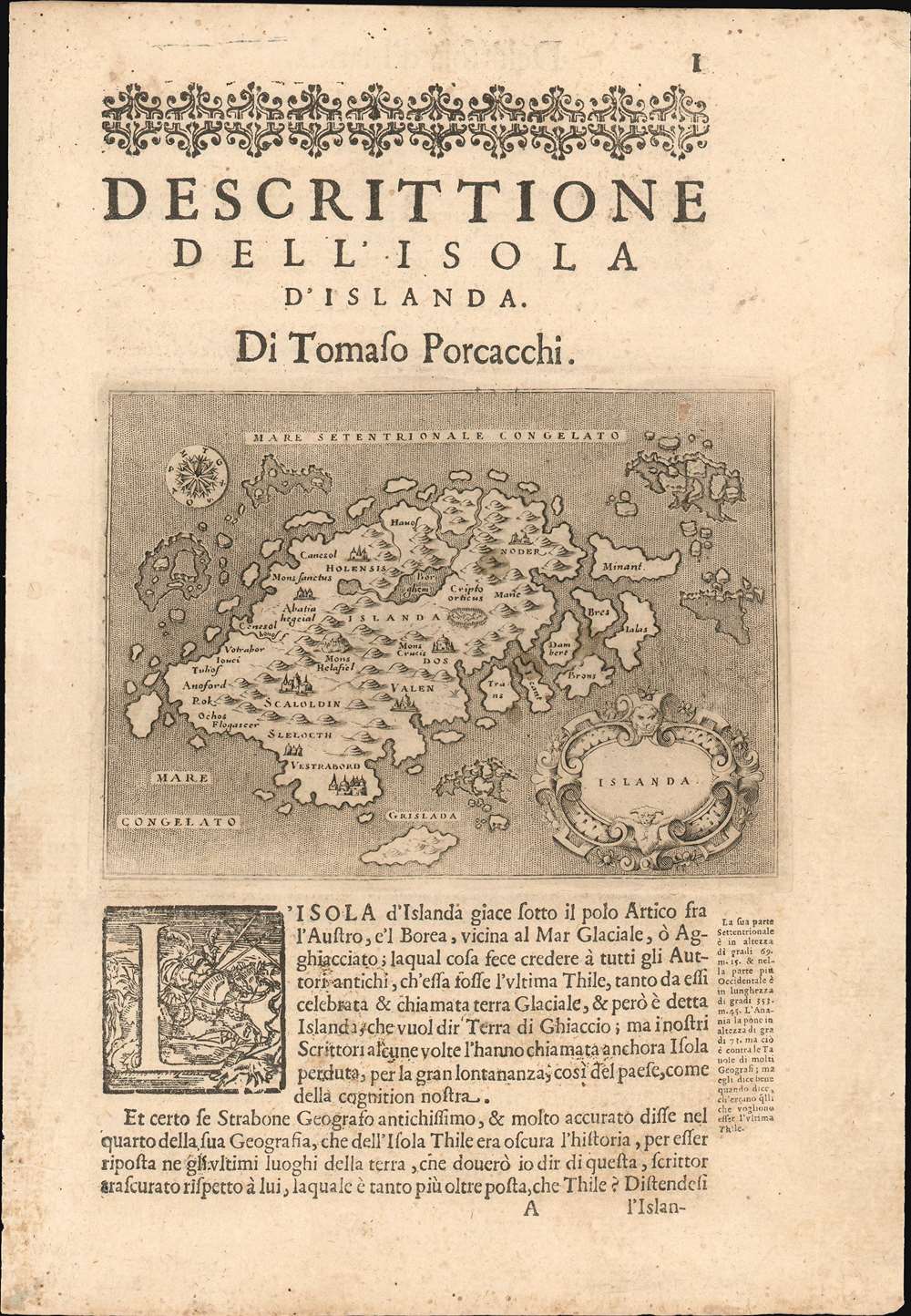

Title
Islanda.
1576 (undated) 4.5 x 6 in (11.43 x 15.24 cm) 1 : 4360000
1576 (undated) 4.5 x 6 in (11.43 x 15.24 cm) 1 : 4360000
Description
FOR THE ORIGINAL ANTIQUE MAP, WITH HISTORICAL ANALYSIS, CLICK HERE.
Digital Map Information
Geographicus maintains an archive of high-resolution rare map scans. We scan our maps at 300 DPI or higher, with newer images being 600 DPI, (either TIFF or JPEG, depending on when the scan was done) which is most cases in suitable for enlargement and printing.
Delivery
Once you purchase our digital scan service, you will receive a download link via email - usually within seconds. Digital orders are delivered as ZIP files, an industry standard file compression protocol that any computer should be able to unpack. Some of our files are very large, and can take some time to download. Most files are saved into your computer's 'Downloads' folder. All delivery is electronic. No physical product is shipped.
Credit and Scope of Use
You can use your digial image any way you want! Our digital images are unrestricted by copyright and can be used, modified, and published freely. The textual description that accompanies the original antique map is not included in the sale of digital images and remains protected by copyright. That said, we put significant care and effort into scanning and editing these maps, and we’d appreciate a credit when possible. Should you wish to credit us, please use the following credit line:
Courtesy of Geographicus Rare Antique Maps (https://www.geographicus.com).
How Large Can I Print?
In general, at 300 DPI, you should at least be able to double the size of the actual image, more so with our 600 DPI images. So, if the original was 10 x 12 inches, you can print at 20 x 24 inches, without quality loss. If your display requirements can accommodate some loss in image quality, you can make it even larger. That being said, no quality of scan will allow you to blow up at 10 x 12 inch map to wall size without significant quality loss. For more information, it is best consult a printer or reprographics specialist.
Refunds
If the high resolution image you ordered is unavailable, we will fully refund your purchase. Otherwise, digital images scans are a service, not a tangible product, and cannot be returned or refunded once the download link is used.
Cartographer S
Tomaso Porcacchi Castilione (1530 - 1585) was a Venetian geographer, humanist, historian, and author active in the mid 16th century. Porcacchi, as he is most commonly known, was born in the Val di Chiana and lived for a time in Florence and where he enjoyed the patronage of Cosimo de Medici. He was married to the Italian poetess Bianca d'Este. Porcacchi is best known as the author of the 1572 L'Isole piu Famose del Mondo. L'Isole was published in response to increase in general interest in geography following the many important explorations and discoveries of the last century. His most important cartographic contribution is the Mundo Novo, the first specific map of North America as a continent - published in L'Isole. Porcacchi died in Venice in 1585. More by this mapmaker...
Olaus Magnus (October 1490 - August 1, 1557), whose name is Latinized from Månsson, was a Swedish writer and Catholic canon and archdeacon. A mission to secure an archbishopric for his brother Johannes led him to travel to Rome in 1524, and thereafter he remained broad engaged in diplomacy until the victory of the reformation in Sweden exiled him permanently, first to Poland and then to Rome in 1537. Magnus' contributions to geography are his 1539 map Carta marina et Descriptio septemtrionalium terrarum and his 1555 Historia de Gentibus Septentrionalibus (a collection of folklore and history which for a century remained the European authority on Sweden, its people and its climate.) Carta Marina, a 9-sheet woodcut map surviving in but two known copies, was deeply influential, providing the dominant model for the mapping of the northern parts of Europe prior to Ortelius. The map has withstood scrutiny even to this day in some respects. Modern oceanographers have analyzed Magnus' work and found his descriptions of currents between Iceland and the Faroe islands to be accurate. Learn More...
NICOLÒ Zeno (1326-1402) and ANTONIO Zeno (d.1403) were two Venetian brothers whose supposed voyage to the north Atlantic and Nova Scotia - invented and publicized by a descendant in 1558 - provided the basis for a map whose fraudulent data was considered genuine for more than fifty years. The 1558 Zeno map's mythical islands and place names were propagated not only on maps produced by Mercator and Ortelius in the 16th century but even on the maps of Blaeu and other preeminent mapmakers well into the 17th century. Among the blatant lies to appear on the map is the utterly imaginary island of Frisland, shown with greater detail than Iceland, an island widely reputed to actually exist. Learn More...
Source
Porcacchi, T. L'Isole piu famose del Mondo(Venice,Galignani) c. 1572
References
OCLC 233522868.