This copy is copyright protected.
Copyright © 2025 Geographicus Rare Antique Maps
Digital Image: 1849 Symonds Linen Map of Jerusalem (first scientific survey of Jerusalem)
Jeruslaem-symonds-1849_d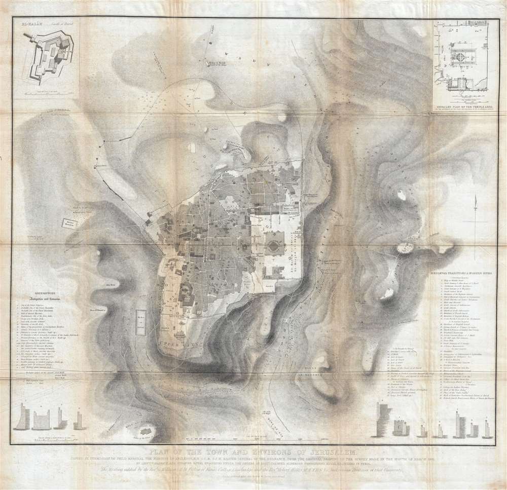

FOR THE ORIGINAL ANTIQUE MAP, WITH HISTORICAL ANALYSIS, CLICK HERE.
Digital Map Information
Geographicus maintains an archive of high-resolution rare map scans. We scan our maps at 300 DPI or higher, with newer images being 600 DPI, (either TIFF or JPEG, depending on when the scan was done) which is most cases in suitable for enlargement and printing.
Delivery
Once you purchase our digital scan service, you will receive a download link via email - usually within seconds. Digital orders are delivered as ZIP files, an industry standard file compression protocol that any computer should be able to unpack. Some of our files are very large, and can take some time to download. Most files are saved into your computer's 'Downloads' folder. All delivery is electronic. No physical product is shipped.
Credit and Scope of Use
You can use your digial image any way you want! Our digital images are unrestricted by copyright and can be used, modified, and published freely. The textual description that accompanies the original antique map is not included in the sale of digital images and remains protected by copyright. That said, we put significant care and effort into scanning and editing these maps, and we’d appreciate a credit when possible. Should you wish to credit us, please use the following credit line:
Courtesy of Geographicus Rare Antique Maps (http://www.geographicus.com).
How Large Can I Print?
In general, at 300 DPI, you should at least be able to double the size of the actual image, more so with our 600 DPI images. So, if the original was 10 x 12 inches, you can print at 20 x 24 inches, without quality loss. If your display requirements can accommodate some loss in image quality, you can make it even larger. That being said, no quality of scan will allow you to blow up at 10 x 12 inch map to wall size without significant quality loss. For more information, it is best consult a printer or reprographics specialist.
Refunds
If the high resolution image you ordered is unavailable, we will fully refund your purchase. Otherwise, digital images scans are a service, not a tangible product, and cannot be returned or refunded once the download link is used.
John Frederick Anthony Symonds (c. 1815 – 1852) was a British Army officer and surveyor. He was the son of Admiral Sir William Symonds, the Surveyor of the Navy. Following in his father's footsteps Symonds joined the Royal Engineers in 1833 and, by 1846, had attained the rank of Major. He was awarded the 1843 Patron's Gold Medal by the Royal Geographical Society for his revolutionary surveys in Palestine. Symonds died while serving at Argostoli, in the Greek Ionian Islands. More by this mapmaker...
Edward Aldrich (December 30, 1802 – November 23, 1857) was an English army officer, architect, and surveyor with the Royal Engineers. Aldrich was part of a detachment sent to survey Syria and Palestine in the 1840s. He was subsequently reassigned to Hong Kong where Aldrich Bay is named after him. He achieved the rank of Colonel before dying at age 57 in Marylebone, London. Learn More...
Joseph Wilson Lowry (October 7, 1803 – June 15, 1879) was an English engraver active in London during middle to later 19th century. Joseph was the son of Wilson Lowry (1760 – 1824), also an engraver under whom he apprenticed. Lowry produced numerous important maps for other publishers and even introduced his own atlas, Lowry's Table Atlas, in 1852. He was appointed engraver to the Geological Survey of Great Britain and Ireland. Learn More...
Copyright © 2025 Geographicus Rare Antique Maps | Geographicus Rare Antique Maps
This copy is copyright protected.
Copyright © 2025 Geographicus Rare Antique Maps