This copy is copyright protected.
Copyright © 2025 Geographicus Rare Antique Maps
Digital Image: 1838 Carless Map of Karachi City and Harbor - fist map of Karachi!
Karachi-carless-1838_d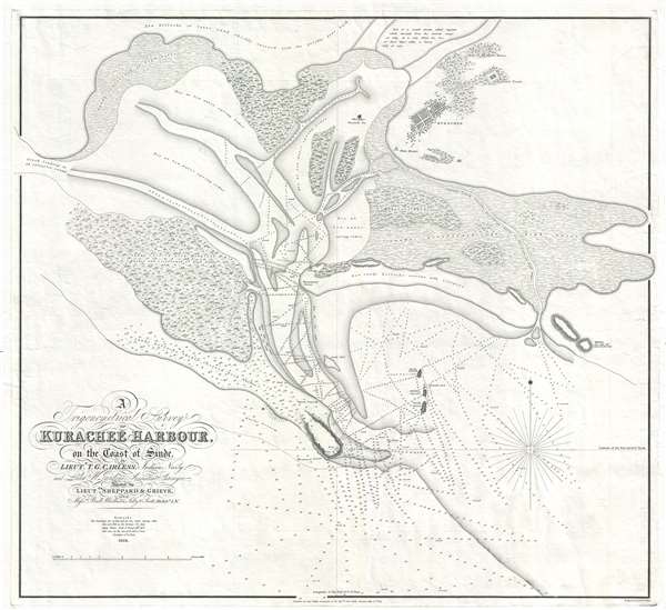

FOR THE ORIGINAL ANTIQUE MAP, WITH HISTORICAL ANALYSIS, CLICK HERE.
Digital Map Information
Geographicus maintains an archive of high-resolution rare map scans. We scan our maps at 300 DPI or higher, with newer images being 600 DPI, (either TIFF or JPEG, depending on when the scan was done) which is most cases in suitable for enlargement and printing.
Delivery
Once you purchase our digital scan service, you will receive a download link via email - usually within seconds. Digital orders are delivered as ZIP files, an industry standard file compression protocol that any computer should be able to unpack. Some of our files are very large, and can take some time to download. Most files are saved into your computer's 'Downloads' folder. All delivery is electronic. No physical product is shipped.
Credit and Scope of Use
You can use your digial image any way you want! Our digital images are unrestricted by copyright and can be used, modified, and published freely. The textual description that accompanies the original antique map is not included in the sale of digital images and remains protected by copyright. That said, we put significant care and effort into scanning and editing these maps, and we’d appreciate a credit when possible. Should you wish to credit us, please use the following credit line:
Courtesy of Geographicus Rare Antique Maps (http://www.geographicus.com).
How Large Can I Print?
In general, at 300 DPI, you should at least be able to double the size of the actual image, more so with our 600 DPI images. So, if the original was 10 x 12 inches, you can print at 20 x 24 inches, without quality loss. If your display requirements can accommodate some loss in image quality, you can make it even larger. That being said, no quality of scan will allow you to blow up at 10 x 12 inch map to wall size without significant quality loss. For more information, it is best consult a printer or reprographics specialist.
Refunds
If the high resolution image you ordered is unavailable, we will fully refund your purchase. Otherwise, digital images scans are a service, not a tangible product, and cannot be returned or refunded once the download link is used.
Thomas Greer Carless (1806 - December 16, 1848) was a British hydrographer and naval officer active in the Indian Navy. Carless distinguished himself in the First Anglo-Burmese War (1824-1826). Following the war, he was assigned to assist Robert Moresby in the important 1831 – 1833 survey of the Red Sea, for which he is today best known. Carless was next assigned to Captain Haines where he produced a hydrographic survey of the South Coast of Arabia. In 1837, he was transferred to Africa in the vicinity of Cape Guardafui (Ras Asir, Somalia) where he surveyed much of the coast. In 1838, Carless was sent to survey the Indus River, work for which he is less well known but which is perhaps his most historically significant. This included the first survey of Karachi Harbor, presaging the 1839 British East India Company occupation of subsequent development of that city as a major port. Carless' work with Moresby in the Red Sea was highly praised for by none other than Richard F. Burton, who wrote in First Footsteps in East Africa,
The beautiful maps of the Red Sea, drafted by the late Commodore Carless, then a lieutenant, will ever remain permanent monuments of Indian Naval Science, and the daring of its officers and men.He was subsequently variously employed throughout the region, including 1846 survey correction work in the Persian Gulf. There he attained the rank of Commodore and was given command of the Persian Gulf Squadron, but he unfortunately contacted Small Pox shortly after and died in the city of Bushehr (Iran). More by this mapmaker...
John Walker (1787 - April 19, 1873) was a British map seller, engraver, lithographer, hydrographer, geographer, draughtsman, and publisher active in London during the 19th century. Walker published both nautical charts and geographical maps. His nautical work is particularly distinguished as he was an official hydrographer for the British East India Company, a position, incidentally, also held by his father of the same name. Walker's maps, mostly published after 1827, were primarily produced with his brothers Charles Walker and Alexander Walker under the imprint J. and C. Walker. Among their joint projects are more than 200 maps for the influential Society for the Diffusion of Useful Knowledge Atlas (SDUK). In addition they published numerous charts for James Horsburgh and the British Admiralty Hydrographic Office, including Belcher's important map of Hong Kong and Carless' exploratory map of Karachi. The J. and C. Walker firm continued to publish after both Walkers died in the 1870s. Learn More...
Copyright © 2025 Geographicus Rare Antique Maps | Geographicus Rare Antique Maps
This copy is copyright protected.
Copyright © 2025 Geographicus Rare Antique Maps