Digital Image: 1744 Wren Map of London, England
London-wren-1744_d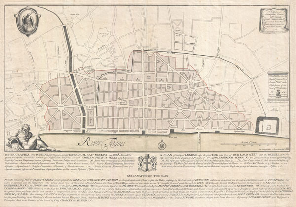

Title
Ichnographia urbis Londinii… (A Plan of the City of London, after the great FIRE, in the Year of Our Lord 1666.)
1744 (dated) 19 x 27.5 in (48.26 x 69.85 cm)
1744 (dated) 19 x 27.5 in (48.26 x 69.85 cm)
Description
FOR THE ORIGINAL ANTIQUE MAP, WITH HISTORICAL ANALYSIS, CLICK HERE.
Digital Map Information
Geographicus maintains an archive of high-resolution rare map scans. We scan our maps at 300 DPI or higher, with newer images being 600 DPI, (either TIFF or JPEG, depending on when the scan was done) which is most cases in suitable for enlargement and printing.
Delivery
Once you purchase our digital scan service, you will receive a download link via email - usually within seconds. Digital orders are delivered as ZIP files, an industry standard file compression protocol that any computer should be able to unpack. Some of our files are very large, and can take some time to download. Most files are saved into your computer's 'Downloads' folder. All delivery is electronic. No physical product is shipped.
Credit and Scope of Use
You can use your digial image any way you want! Our digital images are unrestricted by copyright and can be used, modified, and published freely. The textual description that accompanies the original antique map is not included in the sale of digital images and remains protected by copyright. That said, we put significant care and effort into scanning and editing these maps, and we’d appreciate a credit when possible. Should you wish to credit us, please use the following credit line:
Courtesy of Geographicus Rare Antique Maps (http://www.geographicus.com).
How Large Can I Print?
In general, at 300 DPI, you should at least be able to double the size of the actual image, more so with our 600 DPI images. So, if the original was 10 x 12 inches, you can print at 20 x 24 inches, without quality loss. If your display requirements can accommodate some loss in image quality, you can make it even larger. That being said, no quality of scan will allow you to blow up at 10 x 12 inch map to wall size without significant quality loss. For more information, it is best consult a printer or reprographics specialist.
Refunds
If the high resolution image you ordered is unavailable, we will fully refund your purchase. Otherwise, digital images scans are a service, not a tangible product, and cannot be returned or refunded once the download link is used.
Cartographer S
Christopher Wren (October 20, 1632-February 25, 1723) was an English architect and geometer active in the later 16th and early 17th century. Wren is considered to be one of the most prolific and highly acclaimed English architects in history. In the late 17th century architecture such as we know it today did not exist, rather it was considered a branch of mathematics and as such was consequently an acceptable hobby for the gentleman of distinction. Wren acquired an interested in architecture as a young man and developed his interest through varied studies at Oxford. Wren career as a architect received a significant boost from the Great London Fire of 1666, which facilitated an almost complete reconstruction of much of the city. Wren is responsible for some 55 churches as well as numerous other significant works. In recognition of his accomplishments Wren was knighted on November 14, 1673. He was also a founding father of the Royal Society. Though sickly as a child, Wren lived to a ripe old age 90. Wren is said to have passed away after taking ill on a trip to London in order admire his greatest masterpiece, St. Pauls Cathedral. More by this mapmaker...
Paul Fourdrinier (December 20, 1698-February, 1758) was an engraver and print seller active in London, England during the first half of the 18th century. Paul Fourdrinier, who is also known to have published under the names Peter Fourdrinier and Pierre Fourdrinier, was of French Huguenot extraction from Dieppe, Normandy. His family fled to Groningen, the Netherlands, in the late 17th century. It was here that Paul was born and raised. As a young man he studied engraving with the well known Amsterdam engraver Bernard Picart. Around 1720 Fourdrinier and his wife, Jeanne Theroude, relocated to London. Fourdrinier's aptitude as an engraver quickly attracted a following in London where he is known to have produced a number of important portraits and views, most of where are simply signed "P. Fourdrinier". Fourdrinier was a member of the parish of St. Martin's-in-the-Fields. He died in January of February of 1758, leaving a son, Henry Fourndrinier, to follow in his footsteps. Learn More...
References
Yale University, British Arts, Folio A G 11. British Library, Maps CC.5.a.197. Folger Library, MAP L85c no. 25.