This copy is copyright protected.
Copyright © 2025 Geographicus Rare Antique Maps
Digital Image: 1845 Brown and Parsons Map of Maine, New Hampshire, and Vermont
MENHVT-brownparsons-1845_d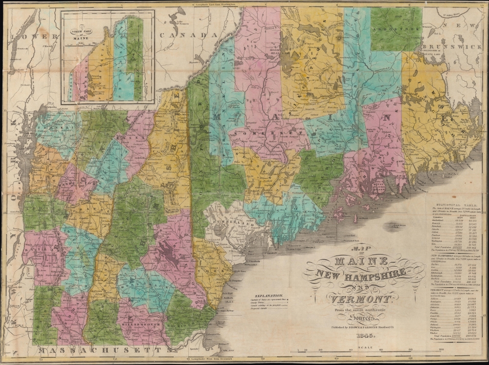

FOR THE ORIGINAL ANTIQUE MAP, WITH HISTORICAL ANALYSIS, CLICK HERE.
Digital Map Information
Geographicus maintains an archive of high-resolution rare map scans. We scan our maps at 300 DPI or higher, with newer images being 600 DPI, (either TIFF or JPEG, depending on when the scan was done) which is most cases in suitable for enlargement and printing.
Delivery
Once you purchase our digital scan service, you will receive a download link via email - usually within seconds. Digital orders are delivered as ZIP files, an industry standard file compression protocol that any computer should be able to unpack. Some of our files are very large, and can take some time to download. Most files are saved into your computer's 'Downloads' folder. All delivery is electronic. No physical product is shipped.
Credit and Scope of Use
You can use your digial image any way you want! Our digital images are unrestricted by copyright and can be used, modified, and published freely. The textual description that accompanies the original antique map is not included in the sale of digital images and remains protected by copyright. That said, we put significant care and effort into scanning and editing these maps, and we’d appreciate a credit when possible. Should you wish to credit us, please use the following credit line:
Courtesy of Geographicus Rare Antique Maps (http://www.geographicus.com).
How Large Can I Print?
In general, at 300 DPI, you should at least be able to double the size of the actual image, more so with our 600 DPI images. So, if the original was 10 x 12 inches, you can print at 20 x 24 inches, without quality loss. If your display requirements can accommodate some loss in image quality, you can make it even larger. That being said, no quality of scan will allow you to blow up at 10 x 12 inch map to wall size without significant quality loss. For more information, it is best consult a printer or reprographics specialist.
Refunds
If the high resolution image you ordered is unavailable, we will fully refund your purchase. Otherwise, digital images scans are a service, not a tangible product, and cannot be returned or refunded once the download link is used.
Flavius A. Brown (August 31, 1806 - February 13, 1880) was an educator, politician, and publisher based in Hartford, Connecticut. Born in Hebron, Connecticut, Brown became renowned at a young age for his penmanship and by age 16 had become a teacher. After helping to construct a new schoolhouse in Hartford, which came to bear his name, Brown served as the chairman of the city's First School District for many years afterwards. He took on other roles in the community, including as secretary of the Hartford County Agricultural Society, and in business, serving as the director of several banks and insurance companies. He was elected Treasurer of Hartford in 1857. His career in publishing began with a business partnership with buying out the H.F. Sumner and Company bookstore in 1834, renamed Packard and Brown, and in 1837 renamed again to Brown and Parsons (Edward W. Parsons). Parsons retired in 1852 and Brown took on one W. Gross as a partner until he stepped back to focus on other pursuits from 1858. Still, the name Brown and Gross continued to be used and it remained a prominent publisher into the late 19th century. More by this mapmaker...
Hiram Frederick Sumner (February 14, 1800 - March 3, 1874) was an American publisher and bookseller. Born in Hebron, Connecticut, Sumner founded H.F. Sumner and Company in 1830. Flavius A. Brown (a former Sumner employee) and Caleb M. Packard bought out the H.F. Sumner and Company bookstore at 20 State Street in Hartford, Connecticut in 1834, and operated it as Packard and Brown for three years. Packard retired in 1837 and E.W. Parsons joined the firm, which was renamed Brown and Parsons. Brown and Parsons remained at the State Street location until 1844. Very little else is known about Sumner's professional life after the sale of H.F. Sumner and Company. Sumner married Caroline G. Conant (1811 - 1883) on August 22, 1830, with whom he had three children. Learn More...
Copyright © 2025 Geographicus Rare Antique Maps | Geographicus Rare Antique Maps
This copy is copyright protected.
Copyright © 2025 Geographicus Rare Antique Maps