This copy is copyright protected.
Copyright © 2025 Geographicus Rare Antique Maps
Digital Image: 1933 Conley and Stelzer Pictorial Map of Chicago, Illinois
MapofChicagoSundayTribune-conley-1933_d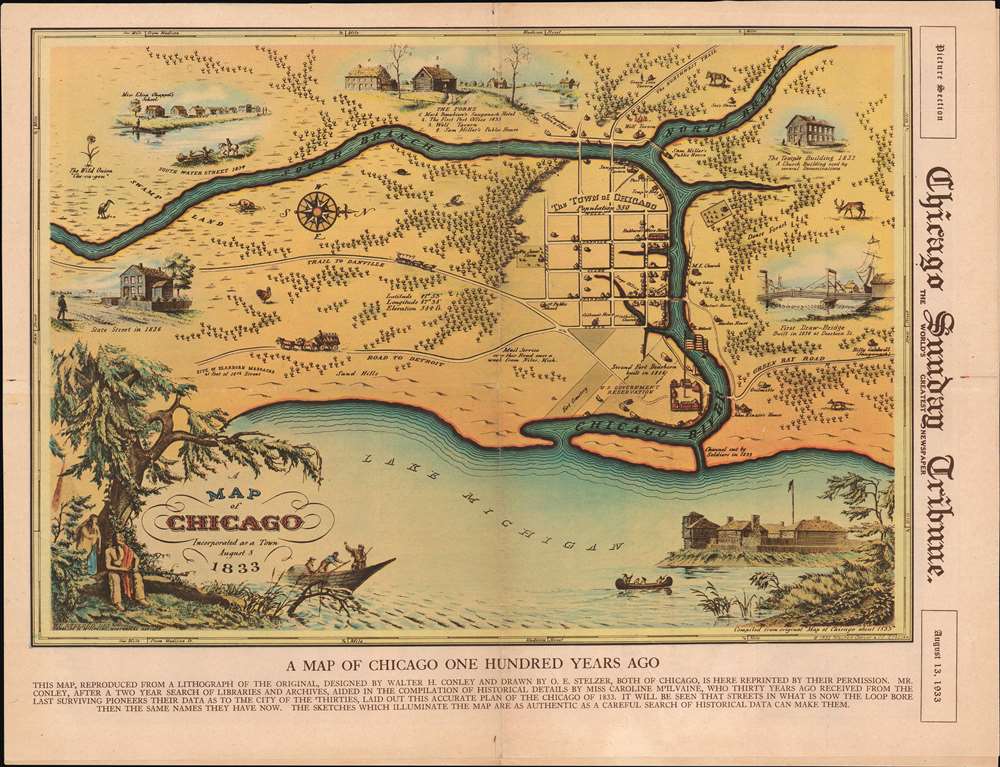

FOR THE ORIGINAL ANTIQUE MAP, WITH HISTORICAL ANALYSIS, CLICK HERE.
Digital Map Information
Geographicus maintains an archive of high-resolution rare map scans. We scan our maps at 300 DPI or higher, with newer images being 600 DPI, (either TIFF or JPEG, depending on when the scan was done) which is most cases in suitable for enlargement and printing.
Delivery
Once you purchase our digital scan service, you will receive a download link via email - usually within seconds. Digital orders are delivered as ZIP files, an industry standard file compression protocol that any computer should be able to unpack. Some of our files are very large, and can take some time to download. Most files are saved into your computer's 'Downloads' folder. All delivery is electronic. No physical product is shipped.
Credit and Scope of Use
You can use your digial image any way you want! Our digital images are unrestricted by copyright and can be used, modified, and published freely. The textual description that accompanies the original antique map is not included in the sale of digital images and remains protected by copyright. That said, we put significant care and effort into scanning and editing these maps, and we’d appreciate a credit when possible. Should you wish to credit us, please use the following credit line:
Courtesy of Geographicus Rare Antique Maps (http://www.geographicus.com).
How Large Can I Print?
In general, at 300 DPI, you should at least be able to double the size of the actual image, more so with our 600 DPI images. So, if the original was 10 x 12 inches, you can print at 20 x 24 inches, without quality loss. If your display requirements can accommodate some loss in image quality, you can make it even larger. That being said, no quality of scan will allow you to blow up at 10 x 12 inch map to wall size without significant quality loss. For more information, it is best consult a printer or reprographics specialist.
Refunds
If the high resolution image you ordered is unavailable, we will fully refund your purchase. Otherwise, digital images scans are a service, not a tangible product, and cannot be returned or refunded once the download link is used.
Walter Haddon Conley (December 3, 1893 - November 3, 1936) was a Chicago based architect active in the middle of the 20th century. Conley was born in Spring Valley, Fillmore, Minnesota. He studied architecture at Beloit College where he was a member of the Alpha Zeta Chapter of the Sigma Chi fraternity. He graduated in 1917. In 1933, Conley completed his only cartographic project. In partnership with Otto Emil Stelzer (1901 - 1984), he drafted and issued a historical map of Chicago as it was in 1833. According to period reports, the map was the product of 2 years of research and caused a popular sensation when published and displayed at the Marshall Field Galleries. When Conley died, at just 42, he was working with the Federal Housing Administration. Conley married Lola Catherine Callaghan on June 18, 1919, in Olmsted, Minnesota, with whom he had a son. More by this mapmaker...
Otto Emil Stelzer (January 5, 1901 - April 1984), was a Swiss-German artist, poet, inventor, entrepreneur, sculptor, and engraver active in Chicago, Illinois; South Bend, Indiana; and Phoenix, Arizona. Stelzer was born in St. Gall, Switzerland. He emigrated to the United States in 1923, initially settling in South Bend, Indiana. He lived briefly in Chicago from 1920 - 1934, but relocated to German, St. Joseph, Indiana by 1935. During this period, in 1933, Stelzer produced two maps, a historical map of South Bend, Indiana as it appeared in 1831, and, in partnership with Walter Haddon Conley (1893 - 1936), a map of Chicago as it appeared in 1933. In 1941 he was employed as a commercial artist with the firm 'Advertising Artists' of South Bend, Indiana. Stelzer also, apparently, dabbled in poetry and was an inventor. For many years, he owned and managed the Aluminum Manufacturing Plant in South Bend, Indiana, from which he retired in 1969. Around this time, he relocated to Phoenix, Arizona, establishing Stelzer Studio, where he dabbled in sculpture, creating lamps, wall sculptures, and candelabras. He died in Phoenix, Arizona, in late April, 1984. In some references Stelzer's name is occasionally miswritten as 'D.E.' Learn More...
Copyright © 2025 Geographicus Rare Antique Maps | Geographicus Rare Antique Maps
This copy is copyright protected.
Copyright © 2025 Geographicus Rare Antique Maps