This copy is copyright protected.
Copyright © 2025 Geographicus Rare Antique Maps
Digital Image: 1931 Ruth Taylor White Pictorial Tourist Map of Maui, Hawaii
Maui-taylor-1931_d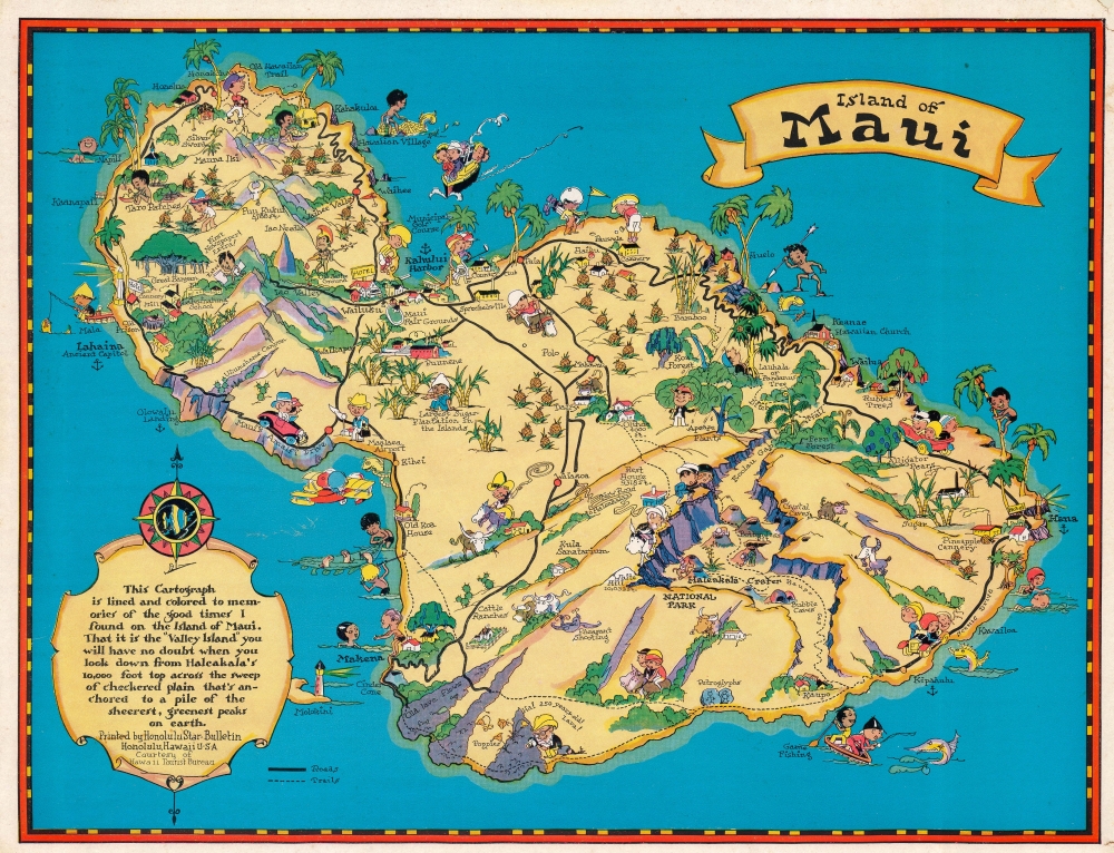

FOR THE ORIGINAL ANTIQUE MAP, WITH HISTORICAL ANALYSIS, CLICK HERE.
Digital Map Information
Geographicus maintains an archive of high-resolution rare map scans. We scan our maps at 300 DPI or higher, with newer images being 600 DPI, (either TIFF or JPEG, depending on when the scan was done) which is most cases in suitable for enlargement and printing.
Delivery
Once you purchase our digital scan service, you will receive a download link via email - usually within seconds. Digital orders are delivered as ZIP files, an industry standard file compression protocol that any computer should be able to unpack. Some of our files are very large, and can take some time to download. Most files are saved into your computer's 'Downloads' folder. All delivery is electronic. No physical product is shipped.
Credit and Scope of Use
You can use your digial image any way you want! Our digital images are unrestricted by copyright and can be used, modified, and published freely. The textual description that accompanies the original antique map is not included in the sale of digital images and remains protected by copyright. That said, we put significant care and effort into scanning and editing these maps, and we’d appreciate a credit when possible. Should you wish to credit us, please use the following credit line:
Courtesy of Geographicus Rare Antique Maps (http://www.geographicus.com).
How Large Can I Print?
In general, at 300 DPI, you should at least be able to double the size of the actual image, more so with our 600 DPI images. So, if the original was 10 x 12 inches, you can print at 20 x 24 inches, without quality loss. If your display requirements can accommodate some loss in image quality, you can make it even larger. That being said, no quality of scan will allow you to blow up at 10 x 12 inch map to wall size without significant quality loss. For more information, it is best consult a printer or reprographics specialist.
Refunds
If the high resolution image you ordered is unavailable, we will fully refund your purchase. Otherwise, digital images scans are a service, not a tangible product, and cannot be returned or refunded once the download link is used.
Ruth D. Taylor White (March 1896 - 20??), a.k.a. Ruth Taylor Day, was an American pictorial mapmaker, what she liked to call 'carto-graphy'. Ruth was born Oregon to the painter John S. Taylor (1858 - 1927). Her interest in cartographic mapmaking was probably inspired by her sister Della Taylor Hoss (1900 - 1997), also an important pictorial cartographer. One of her first published works was a cover of The Stanford Illustrated Review, where her brother Frank attended university. Frank was an accomplished journalist and writer, and Ruth provided the illustrations for two of his books, popular works about the national parks, ’Oh Ranger!’ A Book About the National Parks and Grand Canyon Country. In the spring of 1930, White traveled to Hawaii, where she received a commission from the Hawaii Tourist Bureau to create pictorial maps of the Hawaiian Islands. Sets of five maps began appearing in 1931, with maps of Kauai, Oahu, Maui, Hawaii, and the island chain as part of the set. These were most likely handed out to visitors by the Bureau. White’s most famous work, a pictorial atlas entitled, Our USA: A Gay Geography was published in 1935 and was filled with ‘cartography’ of each state, which she published with her brother as Ruth Taylor. White is also known for her map of Treasure Island, the site of the Golden Gate International Exposition. A third sister, Bernice Taylor Fitzgerald, was also an artist, but did not make maps. Ruth was still an active artist as late as 1997. There is no record of her death, suggesting she may well be a centenarian. More by this mapmaker...
Copyright © 2025 Geographicus Rare Antique Maps | Geographicus Rare Antique Maps
This copy is copyright protected.
Copyright © 2025 Geographicus Rare Antique Maps