Digital Image: 1874 George H. Ellsbury View of Minneapolis
Minneapolis-ellsbury-1874_d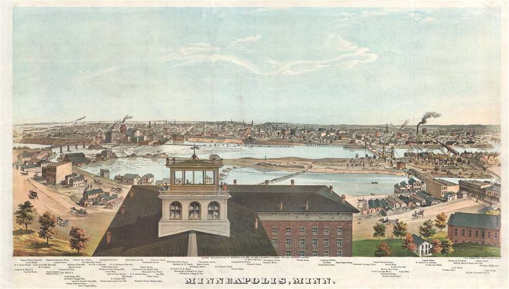

Title
Minneapolis, Minn.
1874 (dated) 17.5 x 29.5 in (44.45 x 74.93 cm)
1874 (dated) 17.5 x 29.5 in (44.45 x 74.93 cm)
Description
FOR THE ORIGINAL ANTIQUE MAP, WITH HISTORICAL ANALYSIS, CLICK HERE.
Digital Map Information
Geographicus maintains an archive of high-resolution rare map scans. We scan our maps at 300 DPI or higher, with newer images being 600 DPI, (either TIFF or JPEG, depending on when the scan was done) which is most cases in suitable for enlargement and printing.
Delivery
Once you purchase our digital scan service, you will receive a download link via email - usually within seconds. Digital orders are delivered as ZIP files, an industry standard file compression protocol that any computer should be able to unpack. Some of our files are very large, and can take some time to download. Most files are saved into your computer's 'Downloads' folder. All delivery is electronic. No physical product is shipped.
Credit and Scope of Use
You can use your digial image any way you want! Our digital images are unrestricted by copyright and can be used, modified, and published freely. The textual description that accompanies the original antique map is not included in the sale of digital images and remains protected by copyright. That said, we put significant care and effort into scanning and editing these maps, and we’d appreciate a credit when possible. Should you wish to credit us, please use the following credit line:
Courtesy of Geographicus Rare Antique Maps (http://www.geographicus.com).
How Large Can I Print?
In general, at 300 DPI, you should at least be able to double the size of the actual image, more so with our 600 DPI images. So, if the original was 10 x 12 inches, you can print at 20 x 24 inches, without quality loss. If your display requirements can accommodate some loss in image quality, you can make it even larger. That being said, no quality of scan will allow you to blow up at 10 x 12 inch map to wall size without significant quality loss. For more information, it is best consult a printer or reprographics specialist.
Refunds
If the high resolution image you ordered is unavailable, we will fully refund your purchase. Otherwise, digital images scans are a service, not a tangible product, and cannot be returned or refunded once the download link is used.
Cartographer S
George H. Ellsbury (November 29,1840 - September 3, 1900) was a Minneapolis, Minnesota based sketch and view artist active in the second half of the 19th century. Ellsbury was born in Skaneateles, New York, in 1814. His family moved to St. Charles, Minnesota in 1857. In 1862, when the American Civil War broke out, he enlisted with the 7th Minnesota Volunteers and saw action on the southern front, eventually attaining the rank of colonel. During the war, he drew a number of battle and camp scenes for Harper's Weekly. After the war, he participated in the General Alfred Sully and General Henry Hasting Sibley Expeditions (1863 – 1864) to the Dakotas and published many of his drawings from the expedition in Frank Leslie's Illustrated Newspaper. Around 1866, returning to Winona County, Minnesota, he was elected as the County Register of Deeds and married Julia Curtis (1827 – 1926). Also, around this time he completed his historic perspective views of Winona, St. Paul, and Minneapolis. Ellsbury later moved to Cass County, Dakota, where he founded Tower City and was part of the fledgling Dakota Southern Railroad Company. In 1888, he moved to Centralia, Washington as a land agent. There he started the Tacoma, Olympia and Chehalis Valley Railroad Company, the Tower Lumber and Manufacturing Company, and Florence Coal Mines. Following a long period of heart and kidney disorders, he died in Centralia on September 3 of 1900. He was given a masonic funeral rite and interred at Washington Lawn Cemetery. Ellsbury was survived by his wife, two sons, and two daughters. More by this mapmaker...
Vernon Green (fl. c. 1860 - 1880) was a Minneapolis based viewmaker and artist active in the late 19th century. Green published views of Minneapolis, St. Paul, Winona with George H. Ellsbury. Learn More...
Charles Shober (February 1831 - c. 1900) was a German-American lithographer and painter. Shober was born in Germany and immigrated to the United States in 1854. He established himself in Philadelphia, at 17 Minor Street, where fellow lithographers and map engravers George Worley and Benjamin Mathias, also worked. His first lithograph in America appeared in an 1855 issue of The Horticulturist. In 1857, he partnered with Charles Reen to establish 'Reen and Shober' at 5 South Sixth Street, Philadelphia. The partners relocated their business to Chicago (106 Lake Street) in 1859. Reen left the firm in 1859 and Charles took a new partner, August Roth, printing under the imprint of 'Charles Shober'. They met with considerable success, until 1871, when like many Chicago businesses, the Great Fire laid them low. After the fire, he took over management and partial ownership of the Chicago Lithographic Company, which had been founded some years earlier by Louis Kurtz and Edward Carqueville. Kurtz's interest in the firm was acquired by Shober and it was renamed 'Charles Shober and Company'. Sometime after 1876, the firm's name changed to 'Shober Lithograph Company', and then in 1877, to 'Shober and Carqueville Lithograph Company'. Despite infighting, the firm prospered, printing views, posters, maps, trade cards, and sheet music. In 1887, after a prolonged dispute with Carqueville, Shober left the firm. He traveled briefly then took a position as president of the Chicago Bank Note Company. Shober's son died in a tragic suicide in 1896, after which, Shober seems to have vanished from professional life. He appears in the Chicago directory as late as 1900. Learn More...
References
Rumsey 3034.024. Reps, John, Views and Viewmakers of Urban America (University of Missouri, Columbia, 1984), #1923. Ristow, W., American Maps and Mapmakers: Commercial Cartography in the Nineteenth Century, p. 433-437.