Digital Image: 1935 Nason-Jones Map of Part of Papua New Guinea Marking Gold Deposits
MorobeDistrict-nasonjones-1935_d

Title
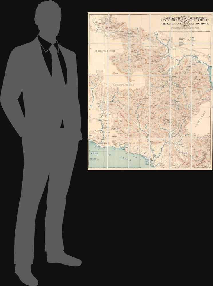
Map of Part of the Morobe District, New Guinea Mandated Territory, and of the Gulf and Central Divisions, Papua.
1935 (dated) 39.25 x 31.75 in (99.695 x 80.645 cm) 1 : 253440
1935 (dated) 39.25 x 31.75 in (99.695 x 80.645 cm) 1 : 253440
Description
FOR THE ORIGINAL ANTIQUE MAP, WITH HISTORICAL ANALYSIS, CLICK HERE.
Digital Map Information
Geographicus maintains an archive of high-resolution rare map scans. We scan our maps at 300 DPI or higher, with newer images being 600 DPI, (either TIFF or JPEG, depending on when the scan was done) which is most cases in suitable for enlargement and printing.
Delivery
Once you purchase our digital scan service, you will receive a download link via email - usually within seconds. Digital orders are delivered as ZIP files, an industry standard file compression protocol that any computer should be able to unpack. Some of our files are very large, and can take some time to download. Most files are saved into your computer's 'Downloads' folder. All delivery is electronic. No physical product is shipped.
Credit and Scope of Use
You can use your digial image any way you want! Our digital images are unrestricted by copyright and can be used, modified, and published freely. The textual description that accompanies the original antique map is not included in the sale of digital images and remains protected by copyright. That said, we put significant care and effort into scanning and editing these maps, and we’d appreciate a credit when possible. Should you wish to credit us, please use the following credit line:
Courtesy of Geographicus Rare Antique Maps (http://www.geographicus.com).
How Large Can I Print?
In general, at 300 DPI, you should at least be able to double the size of the actual image, more so with our 600 DPI images. So, if the original was 10 x 12 inches, you can print at 20 x 24 inches, without quality loss. If your display requirements can accommodate some loss in image quality, you can make it even larger. That being said, no quality of scan will allow you to blow up at 10 x 12 inch map to wall size without significant quality loss. For more information, it is best consult a printer or reprographics specialist.
Refunds
If the high resolution image you ordered is unavailable, we will fully refund your purchase. Otherwise, digital images scans are a service, not a tangible product, and cannot be returned or refunded once the download link is used.
Cartographer S
James Nason-Jones (June 26, 1898 - November 6, 1972) was an English explorer, prospector, and geologist. Born in England, he may have fought with the Royal Flying Corps during World War I. Between 1927 and 1929 Nason-Jones was the leader of the Finsch Coast Geological Survey conducted by the Anglo-Persion Oil Company in New Guinea on behalf of the Australian Commonwealth Government. In the early 1930s Nason-Jones was back in New Guinea and conducted a survey of the gold regions of both Papua and the Mandated Territory from Port Moresby. While in New Guinea he began prospecting for himself, although we have been unable to determine his level of success. In 1934, during his 'work' in New Guinea, found the source of five major rivers in Papua and Papua New Guinea within fifteen miles of each other. In January 1938 he stated that he had mapped 15,000 square miles of Papua and Papua New Guinea while searching for gold and oil. More by this mapmaker...
Herbert Edward Cooper Robinson (November 18, 1856 - January 17, 1933) was a Sydney based Australian cartographer active in the late 19th and early 20th centuries. Cooper was born in Winchester, England and emigrated to Australia with his family, settling in Geelong, Victoria. At around 20 - 25 years of age, Robinson moved to Sydney to join the public service, where he mastered cartographic draftsmanship at the Lands Department. In 1882 he left the Lands Office to found a private firm with the Messrs. Higginbotham and Harris, under the imprint of 'Messrs. Higginbotham, Robinson, and Harris.' Within 2 years, both Higginbotham and Harris left the firm, driving it into bankruptcy and leaving Robinson on his own. In 1895, Robinson set up his own map publishing business at Wentworth Court, moving in 1906 to Phillip Street, and in 1913 to permanent location at 221-223 George Street, Sydney. In 1917, the firm formally incorporated as 'H. E. C. Robinson Ltd.' Although based in Sydney, the firm received multiple government contracts and opened annex firms in the Canberra. Robinson is best known for Australian city and regional guides, but he also published Sir Edgeworth David’s gigantic 1932 Geological Map of the Commonwealth of Australia and Donald Mackay's 1930+ aerial surveys of Australia. In addition to his printing work, in 1885, he became a founding member of the Geographical Society of Australasia. He became a fellow of the Royal Geographical Society in the late 1920s. Robinson had two children, Cecil Robinson and Eileen Robinson Brooks, both of whom emigrated to America. His daughter, Eileen, became a famous American stage actress. Learn More...
References
Australian War Memorial G8140 svar W354. OCLC 224772420.