Digital Image: 1880 Warren Map of Mount Desert Island for Boston and Maine Railroad
MountDesert-bostonmainerr-1880_d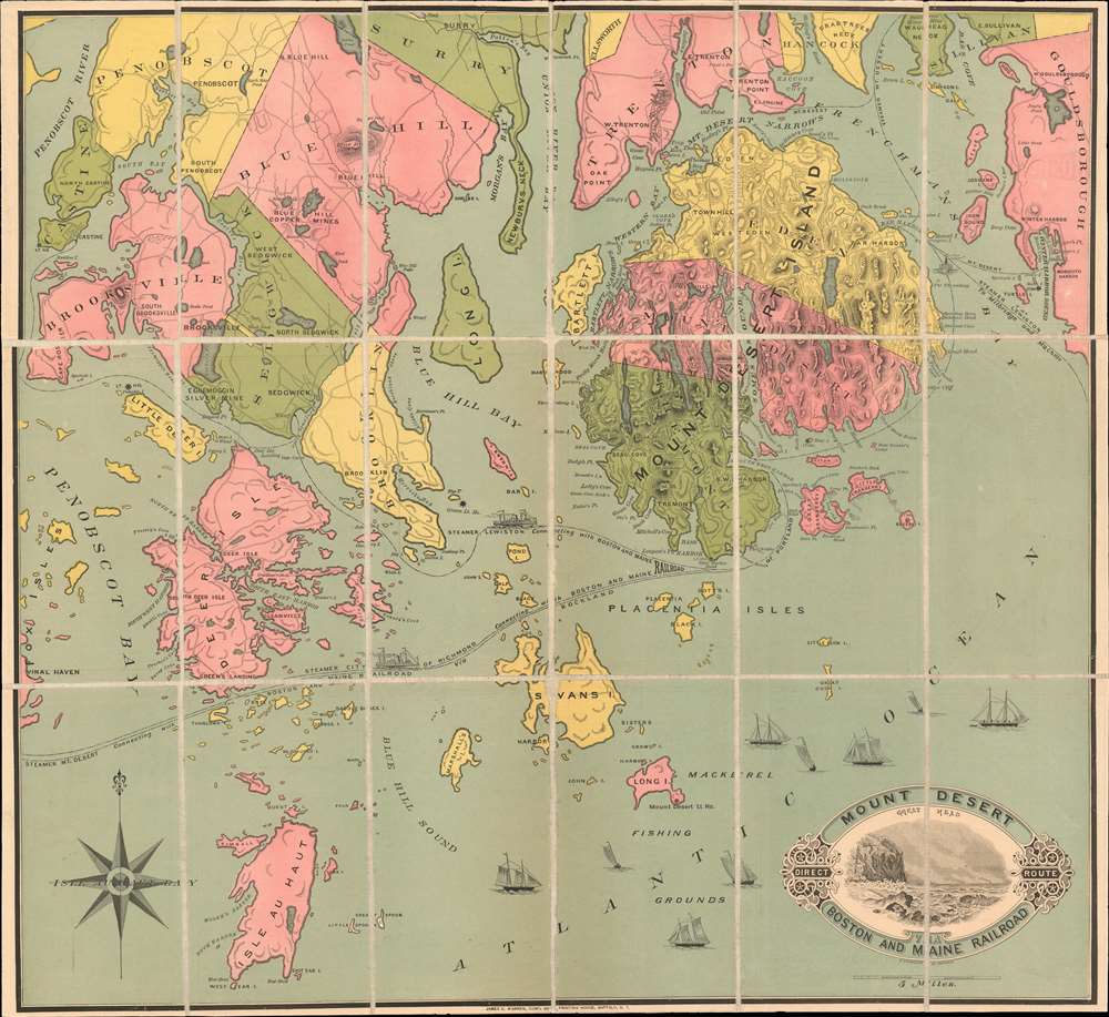

Title
Mount Desert Direct Route vis Boston and Maine Railroad
1880 (dated) 22 x 24 in (55.88 x 60.96 cm) 1 : 110000
1880 (dated) 22 x 24 in (55.88 x 60.96 cm) 1 : 110000
Description
FOR THE ORIGINAL ANTIQUE MAP, WITH HISTORICAL ANALYSIS, CLICK HERE.
Digital Map Information
Geographicus maintains an archive of high-resolution rare map scans. We scan our maps at 300 DPI or higher, with newer images being 600 DPI, (either TIFF or JPEG, depending on when the scan was done) which is most cases in suitable for enlargement and printing.
Delivery
Once you purchase our digital scan service, you will receive a download link via email - usually within seconds. Digital orders are delivered as ZIP files, an industry standard file compression protocol that any computer should be able to unpack. Some of our files are very large, and can take some time to download. Most files are saved into your computer's 'Downloads' folder. All delivery is electronic. No physical product is shipped.
Credit and Scope of Use
You can use your digial image any way you want! Our digital images are unrestricted by copyright and can be used, modified, and published freely. The textual description that accompanies the original antique map is not included in the sale of digital images and remains protected by copyright. That said, we put significant care and effort into scanning and editing these maps, and we’d appreciate a credit when possible. Should you wish to credit us, please use the following credit line:
Courtesy of Geographicus Rare Antique Maps (http://www.geographicus.com).
How Large Can I Print?
In general, at 300 DPI, you should at least be able to double the size of the actual image, more so with our 600 DPI images. So, if the original was 10 x 12 inches, you can print at 20 x 24 inches, without quality loss. If your display requirements can accommodate some loss in image quality, you can make it even larger. That being said, no quality of scan will allow you to blow up at 10 x 12 inch map to wall size without significant quality loss. For more information, it is best consult a printer or reprographics specialist.
Refunds
If the high resolution image you ordered is unavailable, we will fully refund your purchase. Otherwise, digital images scans are a service, not a tangible product, and cannot be returned or refunded once the download link is used.
Cartographer S
Henry Chandler (February 23, 1830 - December 21, 1896) was a Buffalo based engraver, lithographer, and artist active in the mid to late 19th century. Chandler was born in Springfield, Massachusetts, the descendent of William Chandler of Andover, one of the oldest families in the United States. Chandler was born wealthy, but his family wealth was lost in the Panic of 1837. After the loss, he relocated with his family to Seneca County, New York. He was here that he developed his artistic talent, supplementing teaching at the local public school (he was just 15) with sign painting. Chandler relocated to Buffalo, New York in 1850, when he was 20, taking work as a typesetter with the Commercial Advertiser and Journal, a local paper. There, it is claimed he invented wax process engraving - an exceptionally economical printmaking technique that would become popular in the latter 19th century. In 1856 Chandler and his brother Frank Chandler, jointly founded their own engraving and printing enterprise. The business proved successful. They received considerable business from the railway industry, which required copious cost-effective printing, including maps, timetables, and advertising flyers. In 1862, the Chandler brothers partnered with Elam Richardson Jewett (1810 - 1887) to form 'Jewett and Chandler' with the goal of perusing larger government printing contracts. They were successful in securing patent office contracts as well as mapping contracts. Their work drew the attention of the William P. Northrup (1850 - 1910) and James N. Matthews (1828 - 1888) of the Matthews-Northrup Company, which acquired Jewett and Chandler in 1874. Chandler died in 1896 in Buffalo, New York. More by this mapmaker...
James Dunlap Warren (January 19, 1823 - December 17, 1886) was a printer, publisher, engraver, lithographer, businessman, and Republican politician based in Buffalo, New York, in the late 19th century. Warren was born in Bennington, Wyoming County, New York and from age 2 grew up in Clarence, Erie County, New York. He was elected in 1854 to represent Clarence the Erie County Board of Supervisors when he was 31. In 1861, Warren along with Joseph Cander and Rufus Wheeler, operating as 'Rufus Wheeler and Company', acquired the Commercial Advertiser and Journal newspaper from Elam Richardson Jewett (1810 - 1887). In 1862, James N. Matthews (later of Matthews-Northrup; 1828 - 1888), acquired Cander's shares, renaming the holding company 'Wheeler Matthews and Warren'. Wheeler retired in 1865, and the firm was again renamed 'Mathews and Warren.' Nonetheless, by 1877, Warren bought out his partners and became the sole owner. Warren also had a separate printing concern, the 'James D. Warren Printing House' which operated from about 1860 to his death, in 1886, from a bladder infection. At the time, he was one of the wealthiest men in Buffalo. The firm and the newspaper were passed to Warren's sons, William C. Warren (August 4, 1859 - 19??) and Orsamus George Warren (July 21, 1846 - May 6, 1892), who continued to operate as 'James D Warren's Sons Co.' Learn More...
References
OCLC 879769642.