Digital Image: 1911 Bates, Rand, and Jaques Map of Mount Desert Island, Maine
MountDesertIsland-randjaques-1911_d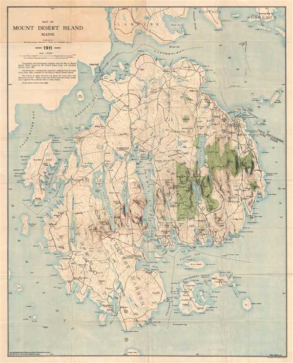

Title
Map of Mount Desert Island Maine.
1911 (dated) 30.5 x 24.5 in (77.47 x 62.23 cm) 1 : 40000
1911 (dated) 30.5 x 24.5 in (77.47 x 62.23 cm) 1 : 40000
Description
FOR THE ORIGINAL ANTIQUE MAP, WITH HISTORICAL ANALYSIS, CLICK HERE.
Digital Map Information
Geographicus maintains an archive of high-resolution rare map scans. We scan our maps at 300 DPI or higher, with newer images being 600 DPI, (either TIFF or JPEG, depending on when the scan was done) which is most cases in suitable for enlargement and printing.
Delivery
Once you purchase our digital scan service, you will receive a download link via email - usually within seconds. Digital orders are delivered as ZIP files, an industry standard file compression protocol that any computer should be able to unpack. Some of our files are very large, and can take some time to download. Most files are saved into your computer's 'Downloads' folder. All delivery is electronic. No physical product is shipped.
Credit and Scope of Use
You can use your digial image any way you want! Our digital images are unrestricted by copyright and can be used, modified, and published freely. The textual description that accompanies the original antique map is not included in the sale of digital images and remains protected by copyright. That said, we put significant care and effort into scanning and editing these maps, and we’d appreciate a credit when possible. Should you wish to credit us, please use the following credit line:
Courtesy of Geographicus Rare Antique Maps (http://www.geographicus.com).
How Large Can I Print?
In general, at 300 DPI, you should at least be able to double the size of the actual image, more so with our 600 DPI images. So, if the original was 10 x 12 inches, you can print at 20 x 24 inches, without quality loss. If your display requirements can accommodate some loss in image quality, you can make it even larger. That being said, no quality of scan will allow you to blow up at 10 x 12 inch map to wall size without significant quality loss. For more information, it is best consult a printer or reprographics specialist.
Refunds
If the high resolution image you ordered is unavailable, we will fully refund your purchase. Otherwise, digital images scans are a service, not a tangible product, and cannot be returned or refunded once the download link is used.
Cartographer S
Waldron Bates (November 24, 1856 - February 9, 1909) was an American lawyer, author, cartographer, and avid outdoorsman. Born in Boston, Massachusetts, Bates attended Harvard and graduated in 1879. He then attended Boston University, from which he received a law degree in 1882. In 1892, Bates joined the Bar Harbor Village Improvement Association, and was named its Path Committee Chairman in 1900, a position he held until his death in 1909, and served as the Association's president from 1904-05. Bates, Edward Rand, and Herbert Jaques published the 'Map of Mount Desert Island' and the 'Path Map of the Eastern Part of Mount Desert Island' in 1896. He was well known around Bar Harbor and Mount Desert Island as a pathmaker. He would plan and build trails leading to geologically interesting rock formations and related sites, and also instituted a uniform method of signage for these trails. On February 9, 1909, Bates tragically passed away when he tried to board a train leaving the railroad station in Monroe, Virginia. According to newspaper accounts, Bates was trying to board a Pullman car, when he lost his footing, slipped, and fell under the departing train. He never married. More by this mapmaker...
Edward Lothrop Rand (August 22, 1859 - October 9, 1924) was an American botanist, lawyer, and cartographer. Born in Dedham, Massachusetts, Rand was born Edward Sprague Rand IV but later changed his name to Edward Lothrop Rand on July 2, 1878, following a scandal involving his father over-mortgaging the family home, evading arrest, and fleeing to Brazil. He attended Harvard University and graduated in 1881 and graduated from Harvard Law School in 1884 and went on to practice law in Boston, but his true passion in life was botany. Rand was famous on Mount Desert Island as one of the members of the Champlain Society and as the first Chairman of the Path Committee on Mount Desert Island. He co-author Flora of Mount Desert Island, Maine with J.H. Redfield and created map of Mount Desert Island with Waldron Bates and Herbert Jaques. Rand married Annie Matilda Crozier on June 29, 1893 in Boston. Learn More...
Herbert Jaques (January 23, 1857 - December 21, 1916) was an American draftsman and cartographer. Born in Framingham, Massachusetts, Jaques studied at MIT. After graduating, he found a job as a draftsman in the offices of Henry Hobson Richardson. Jaques joined forces with another draftsman employed by Richardson, Robert Day Andrews, to create the firm Andrews and Jaques. In 1889, Augustus Neal Rantoul joined the firm, which was renamed Andrews, Jaques, and Rantoul. Andrews, Jaques, and Rantoul designed private residences, but their best known work are public and commercial buildings they designed for clients throughout the United States. Jaques married Harriet Sayles Francis on April 26, 1883. Learn More...
References
OCLC 842839916.