This copy is copyright protected.
Copyright © 2025 Geographicus Rare Antique Maps
Digital Image: 1823 Darton and Gardner Comparative Chart of World Mountains and Rivers
MountainsandRivers-darton-1823_d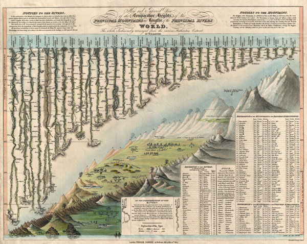

FOR THE ORIGINAL ANTIQUE MAP, WITH HISTORICAL ANALYSIS, CLICK HERE.
Digital Map Information
Geographicus maintains an archive of high-resolution rare map scans. We scan our maps at 300 DPI or higher, with newer images being 600 DPI, (either TIFF or JPEG, depending on when the scan was done) which is most cases in suitable for enlargement and printing.
Delivery
Once you purchase our digital scan service, you will receive a download link via email - usually within seconds. Digital orders are delivered as ZIP files, an industry standard file compression protocol that any computer should be able to unpack. Some of our files are very large, and can take some time to download. Most files are saved into your computer's 'Downloads' folder. All delivery is electronic. No physical product is shipped.
Credit and Scope of Use
You can use your digial image any way you want! Our digital images are unrestricted by copyright and can be used, modified, and published freely. The textual description that accompanies the original antique map is not included in the sale of digital images and remains protected by copyright. That said, we put significant care and effort into scanning and editing these maps, and we’d appreciate a credit when possible. Should you wish to credit us, please use the following credit line:
Courtesy of Geographicus Rare Antique Maps (http://www.geographicus.com).
How Large Can I Print?
In general, at 300 DPI, you should at least be able to double the size of the actual image, more so with our 600 DPI images. So, if the original was 10 x 12 inches, you can print at 20 x 24 inches, without quality loss. If your display requirements can accommodate some loss in image quality, you can make it even larger. That being said, no quality of scan will allow you to blow up at 10 x 12 inch map to wall size without significant quality loss. For more information, it is best consult a printer or reprographics specialist.
Refunds
If the high resolution image you ordered is unavailable, we will fully refund your purchase. Otherwise, digital images scans are a service, not a tangible product, and cannot be returned or refunded once the download link is used.
William Darton (February 2, 1781 - July 28, 1854) was an English publisher and engraver active in Tottenham London during the early part of the 19th century. Darton was the eldest son of William Darton Sr., himself a printer and publisher who co-owned the firm of Harvey and Darton. Darton, a Quaker, was educated at the Friends School in Clerkenwell, London and the Ackworth School in Yorkshire. Afterwards Darton apprenticed to his father where he mastered the part of printing and engraving. Around 1804 Darton opened his own shop, the "Repertory of Genius", specializing in maps, prints, children's books, educational publications, and other "works of merit" at 50 Holborn Hill, London. Cartographically Darton's most significant contribution is his 1823 publication, along with engraver W. R Gardner, of the first composite comparative mountains and rivers chart. Darton also published various maps for the 1802 Atlas to Walker's Geography and his own 1813 Union Atlas. Darton retired in 1851 leaving his business to his son, John Maw Darton, who partnered with Samuel Clark and published as "Darton and Clark". More by this mapmaker...
William R. Gardner (fl. c. 1810 - c. 1850) was and English engraver active in London during the first half of the 19th century. His offices were at 867 Strand Street, London. Gardner worked with many of the most prominent London publishers of his day including Charles Smith and William Darton. His most significant contribution to the world of cartography is his 1823 publication, along with publisher William Darton, of the first composite comparative mountains and rivers chart. Learn More...
Copyright © 2025 Geographicus Rare Antique Maps | Geographicus Rare Antique Maps
This copy is copyright protected.
Copyright © 2025 Geographicus Rare Antique Maps