This copy is copyright protected.
Copyright © 2025 Geographicus Rare Antique Maps
Digital Image: 1881 Stoner View of Nantucket Town, Massachusetts
NantucketView-stoner-1881_d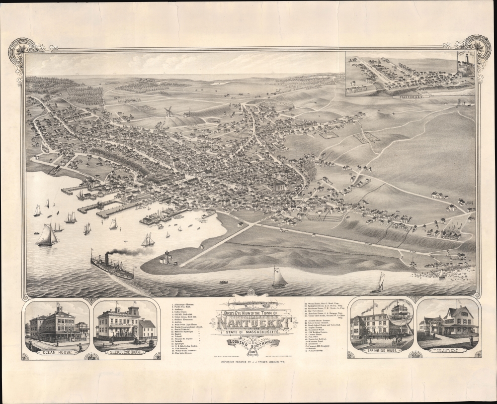


FOR THE ORIGINAL ANTIQUE MAP, WITH HISTORICAL ANALYSIS, CLICK HERE.
Digital Map Information
Geographicus maintains an archive of high-resolution rare map scans. We scan our maps at 300 DPI or higher, with newer images being 600 DPI, (either TIFF or JPEG, depending on when the scan was done) which is most cases in suitable for enlargement and printing.
Delivery
Once you purchase our digital scan service, you will receive a download link via email - usually within seconds. Digital orders are delivered as ZIP files, an industry standard file compression protocol that any computer should be able to unpack. Some of our files are very large, and can take some time to download. Most files are saved into your computer's 'Downloads' folder. All delivery is electronic. No physical product is shipped.
Credit and Scope of Use
You can use your digial image any way you want! Our digital images are unrestricted by copyright and can be used, modified, and published freely. The textual description that accompanies the original antique map is not included in the sale of digital images and remains protected by copyright. That said, we put significant care and effort into scanning and editing these maps, and we’d appreciate a credit when possible. Should you wish to credit us, please use the following credit line:
Courtesy of Geographicus Rare Antique Maps (http://www.geographicus.com).
How Large Can I Print?
In general, at 300 DPI, you should at least be able to double the size of the actual image, more so with our 600 DPI images. So, if the original was 10 x 12 inches, you can print at 20 x 24 inches, without quality loss. If your display requirements can accommodate some loss in image quality, you can make it even larger. That being said, no quality of scan will allow you to blow up at 10 x 12 inch map to wall size without significant quality loss. For more information, it is best consult a printer or reprographics specialist.
Refunds
If the high resolution image you ordered is unavailable, we will fully refund your purchase. Otherwise, digital images scans are a service, not a tangible product, and cannot be returned or refunded once the download link is used.
Joseph John Stoner (December 21, 1829 - May 1917) was a Madison, Wisconsin based publisher of bird's-eye city views active in the late 19th and early 20th centuries. Stoner was born in Highspire, Pennsylvania and apprenticed as a carver of ornamental chairs before turning to publishing. He partnered with the bookseller Ephraim T. Kellogg of Madison, Wisconsin, for whom he was a traveling agent. His career in views began around 1867 when he met and befriended the bird's-eye view artist Albert Ruger, who was sketching Madison that year. Ruger and Stoner partnered and began publishing city views under the imprint 'Ruger & Stoner.' The partners traveled extensively through the Midwest publishing some 11 city views under their joint imprint - although there may be as many as 62 others unattributed. The partnership partially dissolved in 1872 although they continued to work together on a contractual basis. Stoner subsequently traveled even more extensively, hiring young artists to sketch city views in such wide ranging destinations as Texas, Maine, and Oregon, among others. He produced a total of some 314 views with various artists including: Albert Ruger, Herman Brosius, Thaddeus M. Fowler, Augustus Koch, Albert F. Poole, Henry Wellge, Joseph Warner, and Camille N. Drie (Dry). Stoner died in Berkeley, California in 1917. More by this mapmaker...
Beck and Pauli (fl. c. 1878 – 1889) was a Milwaukee, Wisconsin based lithography firm founded in 1878 by Clemens J. Pauli and Adam Beck. The firm published hundreds of lithograph city views for many of the most prominent viewmakers of the period, including Lucien Rinaldo Burleigh, J. J. Stoner, Henry Wellge, Pauli himself, and others. The company was most active in the mid-1880 until about 1889, when the partners went separate ways and closed the company. Learn More...
Copyright © 2025 Geographicus Rare Antique Maps | Geographicus Rare Antique Maps
This copy is copyright protected.
Copyright © 2025 Geographicus Rare Antique Maps